

After a weak frontal passage overnight Friday, the general consensus was that the Seattle area would experience clearing skies by Saturday afternoon with perhaps an isolated shower or two.
Unfortunately the weather had other ideas.

A little after 8:30 AM, the main frontal band was already well off to the southeast and skies were clearing…except in central Puget Sound.
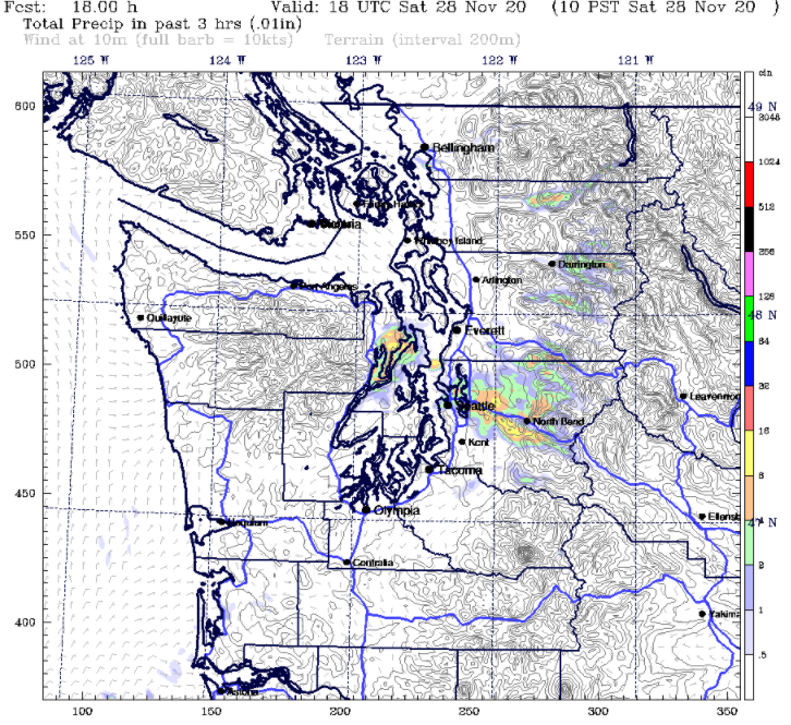
A radar loop shows that precipitation was widespread around 10-11 AM (1800-1900 UTC) and lingered in central Puget Sound until about 1 PM (2100 UTC).

Clearly, a convergence zone can be seen in the above radar loop, although it looks a little strange compared with a typical convergence zone, which usually has a banded appearance.
The above loop also shows some unusual motions. While the convergence zone as a whole was located in the usual spot (Snohomish / north King counties) and had a gradual southerly movement, the motion of the individual rain showers was in more of a south-to-north direction, even as the leading edge of the precipitation moved north-to-south.
Was this really a convergence zone?
As the name implies, a convergence zone requires convergence. On Saturday morning, surface observations did indicate some weak convergence–weak northerly winds in the North Sound and weak southerly winds in the South Sound.

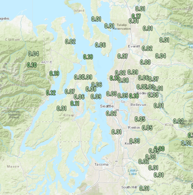
Weak is the key word here. There really wasn’t much wind at all, generally 5 mph or less. And while precipitation totals (below) around a tenth of an inch at most, measurable precipitation was fairly widespread.
Maybe there was a weak frontal boundary?

No sign of any temperature gradients in the sound. Mid-40s everywhere.
So there isn’t anything exceptional to report here. It looks like a weak convergence zone. Convergence zones are a fairly common occurrence after frontal passages. But what was unusual about this case is that the models didn’t really see it coming, or at least didn’t anticipate how widespread the precipitation would be. Why was that the case?
Let’s check the larger scale to see if there are any clues. The 4/3 km UW-WRF shows that high pressure was already centered offshore by 10 AM Saturday.

While high pressure tends to signal a transition to drier conditions, it does not immediately erode all of the lower-level moisture that is present following an overnight rain. In fact, even closer to the surface high on the coast it was nearly saturated from the surface up to 2 km, as seen in the sounding (weather balloon) launched from Quillayute below.

If you are not familiar with how to read the above “skew-T” diagram, the main takeaway is that the temperature and dew point lines are close together from the surface up to about 750 hPa, meaning the air was nearly saturated. So any type of rising motion could potentially lead to precipitation. And since we did have weak convergence in Puget Sound (based on the surface observations shown above), the ingredients were in place to get some rain showers.
Did the models forecast a convergence zone?
Model predictions were all over the place, but there were at least some hints of rain showers associated with a convergence zone. The 4/3 km WRF showed a bit of a convergence zone, but too far south.
The HRRR had nothing except a few showers around Hood Canal.

The ECMWF also had a weak convergence zone, but weak and too far north.

Overall, there was enough model evidence for NWS Seattle office to correctly predict a weak convergence zone in their Friday night forecast.

Not bad, but we’re still left with the fact that nobody expected widespread rain in north King/south Snohomish counties for much of Saturday morning.
What about the unusual nature of the showers in the radar loop?
Perhaps the most interesting aspect of this event was the cellular, convective appearance of the rain showers. In my opinion, the behavior of these showers offers the most compelling clue for why the models underestimated this event.

Rather than a banded appearance, radar showed numerous showers with small cores of moderate rain. The convective nature of these showers suggests that there was some instability present in the atmosphere that was released with help from the weak convergence (and subsequent rising motion) in the Central Sound.
The storm motions, as seen in radar radial velocity imagery, show an interesting pattern:

The KATX radar is located on Camano Island. Red colors represent storm motion away from the radar (north to south). White/green colors represent storm motion toward the radar. The northern part of the precipitation is initially moving to the south, while a few showers to the south are nearly stationary. As time progresses (especially after 1800 UTC or 10 AM), the initial area of showers moves south (watch the red area dropping south), which triggers additional showers on the leading edge of the boundary. These new showers (white/green colors) are moving from south to north, and even appear to lift over the boundary (red colors) that continues to progress south.
This boundary made it all the way down to Sea-Tac airport, where the surface winds shifted from southerly to northerly just before 1 PM.
The precipitation/velocity pattern is reminiscent of a weak, downsized version of a linear convective squall line, similar to the example shown below (more commonly seen east of the Rockies).

What can we conclude from all of this?
- Saturday morning’s convergence zone outperformed all model forecasts, and the timing (when a dry weekend day was predicted) made things worse from a forecasting perspective.
- As the convergence zone developed in Snohomish County, it began to drift southward and trigger additional shower development on the southern flank.
- There was likely some weak instability that was not resolved by the models, which allowed the convergence zone to intensify as showers rapidly developed on its leading, southern edge.
- There was minimal large-scale forcing, so once the convergence zone formed it was able to self-propagate to the south as it continued to trigger new showers.
- This weak convergence zone does not deserve a long blog post, but yet, here we are!
Hopefully there will be more exciting weather to talk about in our next post, but things look rather quiet until the second or third week of December.

“This weak convergence zone does not deserve a long blog post, but yet, here we are! ” 🤣 I know and I was here for it.
LikeLike
You read the whole thing! Gold star!
LikeLike
A couple of weeks ago, Port Townsend got a weak convergence zone coming off of Vancouver Island to the northwest. It put a damper on a sunny forecast, and I didn’t see any mention of it in the NWS forecast discussion. Sadly, we didn’t even get a blog post out of it, so maybe this long comment can help to compensate!
LikeLike
Vancouver Island convergence zones are fun! I’ll do a post about it the next time there is a good one.
LikeLike
I was driving through the quilcene area around 8AM on my way to go hiking and it was pouring rain. Luckily it was only drizzle and fog on the hike but the sun never came out. The excitement of outdoor adventures in the NW in november.
LikeLike