

September 22 is the autumnal equinox and unlike last year, the transition to autumn-like weather is occurring right on schedule. Sea-Tac airport recorded a low in the 40s on Thursday morning for the first time since June 19 and most of the PNW has seen at least some rainfall over the past few weeks.
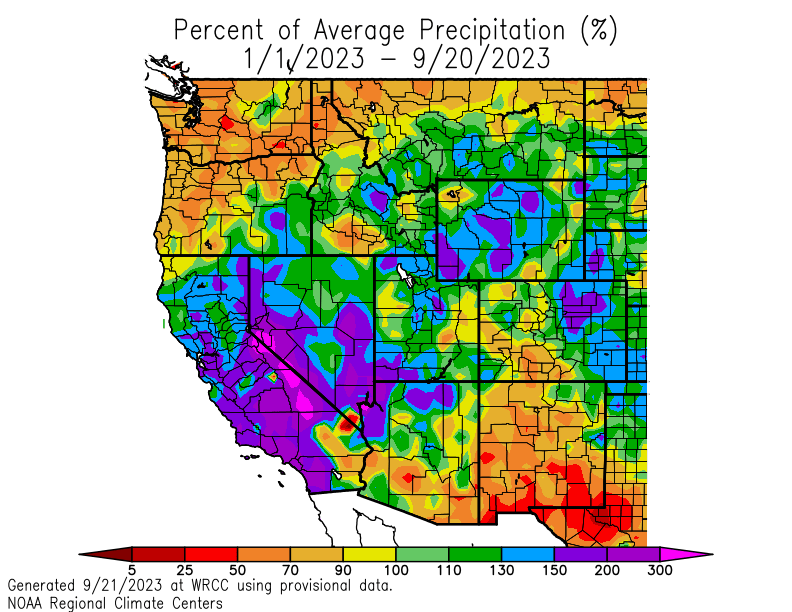
Precipitation is desperately needed, particularly in the western half of Washington and Oregon. Rainfall going back to the start of 2023 has been well below normal, with deficits as much as 15 inches in mountainous areas and on the western side of the Olympic Peninsula. Sea-Tac airport has recorded only 15 inches of rain this year which is just shy of 8 inches below normal.
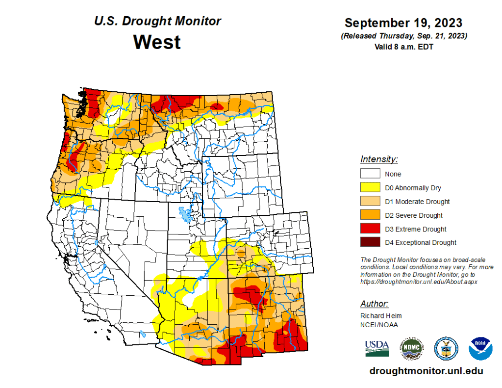
Not surprisingly, drought conditions have been spreading and worsening over the past few months. Around a third of Washington and Oregon are now in “severe” or “extreme” drought with mountain areas experiencing the worst conditions.
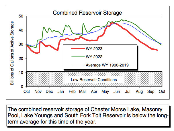
The dry conditions have triggered voluntary water reductions in Seattle, as reservoir levels are running well below normal. Note that Seattle is in no danger of running out of water this year, but another drier-than-normal winter could put further strain on water resources and reduce streamflows in 2024.
A rainy week ahead
Fortunately, a significant early season wet period is expected beginning Saturday and continuing for about a week. The initial frontal system on Saturday will be relatively unimpressive. Beginning Sunday evening, the following series of 3-4 weather systems will look like the typical storms that we see in the depths of winter, with each likely to bring moderate rain to areas west of the Cascades.
The most impressive part about this storm cycle will be the deep area of low pressure that is expected to form offshore of the PNW this weekend, deepen to the mid-970s hPa, and persist through next week before decaying near the northern tip of Vancouver Island. This low would be impressive at any time of year, but it is especially anomalous for September.
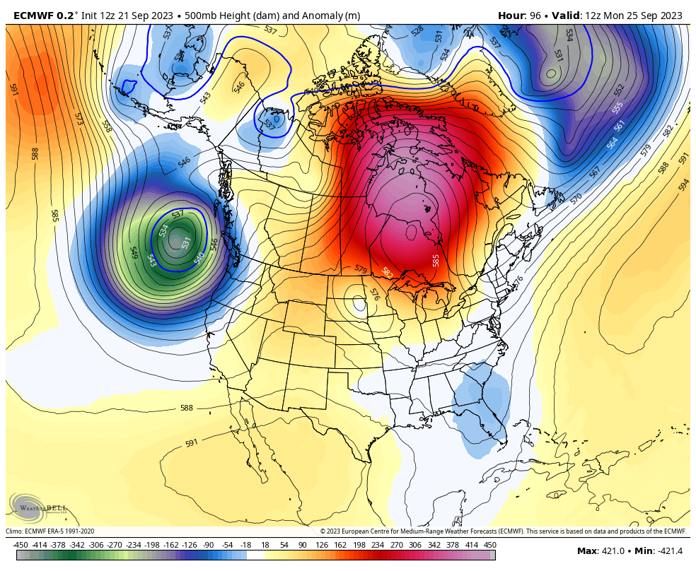
The primary cold front associated with this low pressure system is expected have a fairly strong atmospheric river ahead of it. The integrated vapor transport (IVT) corridor associated with the atmospheric river will reach the WA/OR coast on Monday morning.
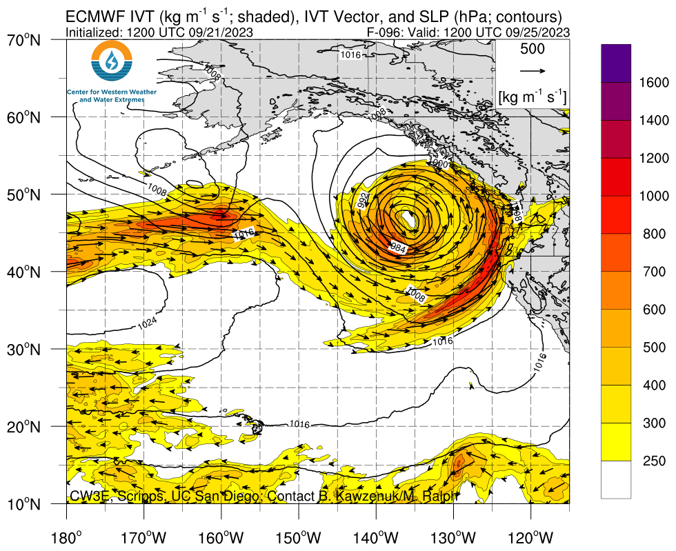
This front is expected to be a slow mover and decay as it pushes inland, so the highest rainfall totals on Sunday night-Monday will be along the coast.
The forecast becomes more uncertain beyond Monday, but right now it looks like two secondary postfrontal waves will follow on Tuesday and Wednesday with some ensemble members additional light rain continuing into the following weekend.
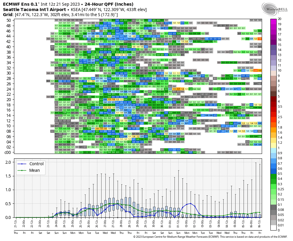
The ECMWF ensemble 24h precipitation forecast for Seattle shows the significant uncertainty remaining in the forecast. Tuesday night into Wednesday looks like the wettest period for Seattle, but each ensemble member tells a different story. Coastal areas will be much wetter than the interior on Monday.
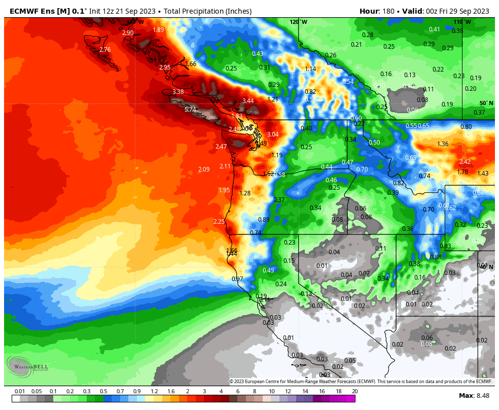
Total precipitation through Thursday evening (ensemble mean) shows that the highest totals will be from the Cascades westward.
All of this rainfall will be highly beneficial, putting an end to our stubborn wildfire season, increasing river streamflow, and soaking trees and plants. While winds are not expected to reach windstorm criteria, the first moderately breezy period of the fall usually causes a disproportionate number of downed trees and branches.
As for drought conditions, we will likely see a little improvement in the next update, but seasonal totals will remain well below normal.

Despite the relatively impressive precip forecast thru the end of the month, there is still an at least 50/50 chance that the 2022-2023 water year will displace that of 1993-1994 as the driest such on record at BLI. As of this writing my CoCoRahs gauge has picked up just over 12″ since 1/1/23. Without substantially above normal precip for the rest of the calendar year, 2023 stands a decent chance of being the driest calendar year on record at BLI.
LikeLike
The morning minimum temp of 42.7F at my location in Bellingham was the coolest since 5/10 and it looks like it’s going to be the last dry, crisp, fall morning for awhile…
LikeLike
My CoCoRahs gauge picked up 0.19″ in Bellingham yesterday.
LikeLike
It’s been considerably drier and windier than forecast around Bellingham today. I’ve measured <0.2" of precip and a 41mph gust so far
LikeLike
It’s now certain that the 2022-2023 water year will go down as the driest on record at BLI. The site would need to receive nearly 1.9″ of precip by the end of the month for it not to. This will be the first time that BLI has ever received less than 24″ of precip during any water year. Also, if precip for the rest of the calendar year is exactly average this will be the 2nd driest calendar year in BLI history. In fact, if BLI receives less than ~87% of normal precip for the rest of the calendar year this will be the driest calendar year in its history. The CPC 3-month outlook issued 9/21 calls for a 40-50% chance of below normal precip for the rest of the year…
LikeLike
Even though we had a recent wet forecast for Western Washington, Bellingham will end up at less than 60% of normal for September. This will mark the 11th month in row with below normal precip. I took another look at the last 3 years of precip for BLI (starting January 1, 2021). Out of the 33 months, 4 were normal, 6 were above normal, and 23 were below normal. Approximately, 16 of the 23 below normal months were considerably below normal. A significant portion of the precip during this period were the 11+ inches in October and November 2021, when we had the damaging floods from a series of pineapple express/atmospheric river events within in a very short period.
I also took another look at the current Drought Monitor for Whatcom County, 80% of which is now classified as Extreme Drought. What is interesting (and what should be concerning for residents of Whatcom County) is the Extreme Drought includes areas bordering most of Bellingham Bay. About the only western portion of Whatcom County that is in Severe rather than Extreme Drought is a narrow strip on the water north of the airport.
I would be more concerned that we have had a somewhat prolonged period of low precipitation rather than in just 2023. According to the Drought Monitor website, 2023 is the 7th driest year to date over the past 129 years, so we have not broken a record for this year. However, the current dryness follows a period of below average precip. I’m not sure how beneficial the floods in the end of 2021 were beneficial in terms of replenishing ground water.
https://www.weather.gov/wrh/timeseries?site=AV482&hours=72
LikeLike