

After an active start to November, the PNW has experienced several weeks of quiescent weather with few notable events to report. While convenient for holiday travel, it marks the second straight year that November precipitation will end up below average in many areas west of the Cascades.
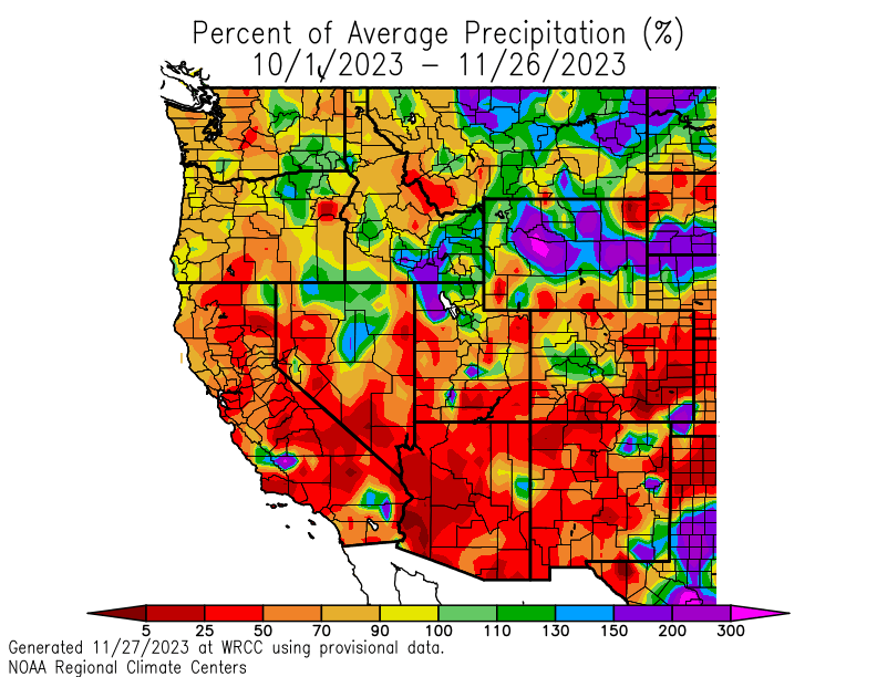
Looking at the water year to date (since October 1), the southwestern US has seen the worst precipitation deficits but most of the western half of Washington and Oregon are running between 70 and 90 percent of normal precipitation.
It’s easy to get concerned about these early deficits, but I have some optimism to offer. If wet season was a game of football, we’re currently at the end of the first quarter. Our hypothetical football game is a one score game, meaning most areas can get back to even in just one storm cycle. And mother nature is about to punt the ball right back to us in the form of an impressive stormy period to begin December.
Active Pacific Jet Stream
One of the first signs of a wet period in our region is an active zonal jet steam over the Pacific Ocean, with “zonal” meaning a jet that is orientated west to east. On weather maps this often looks like a big finger pointed right at the PNW.
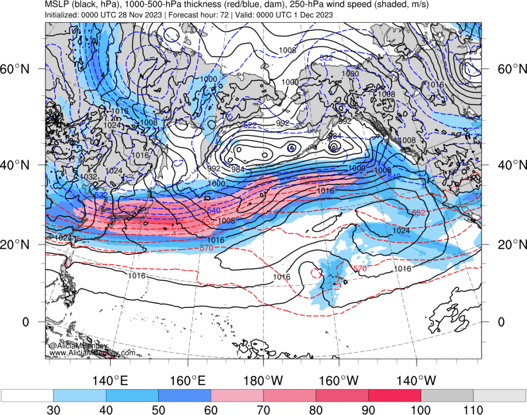
In an active zonal pattern, storm systems tend to approach from the west and move through quickly with a cadence of about one storm every other day. It looks like that will be the case this weekend, with storms impacting the PNW on Friday, Sunday, and Tuesday. A fourth storm remains a possibility later next week.
Some good news for mountain snowpack
Many skiers and snowboarders are wondering when our local ski resorts will be able to open. The good news is that the first storm on Friday-Saturday will be our best snowmaker of the year so far. The snow level will be below the passes for the entire event and the storm should produce 1-2 inches of liquid equivalent on the western side of the Cascades.
It’s a sight for sore eyes to see a snow map with a foot or more of snow in the mountains.
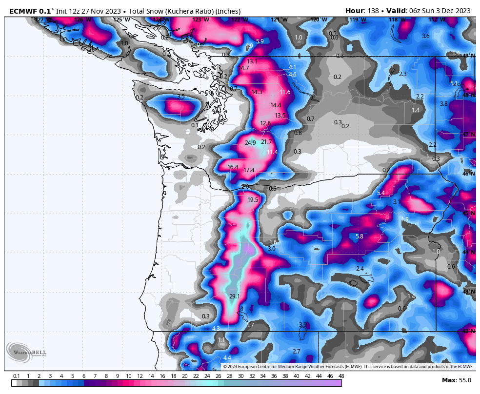
Unfortunately, storms 2 and 3 on Sunday and Tuesday both look like atmospheric rivers that will tap into subtropical moisture. I have some hope that Sunday’s system will produce some additional snowfall before changing to rain, at least in the passes. Easterly winds will try to keep the snow levels down until the frontal passage later Sunday night. Snow levels may also stay fairly low in the north Cascades and British Columbia.
The third storm that is slated for next Tuesday looks like a full blown pineapple express with a southerly orientation and potentially several inches of rain with snow levels above everything except the volcanoes.
However — I’ll end with a bit of good news — beyond Tuesday it again looks to turn colder and there could potentially be another snow producing storm later next week. It’s too early to tell, but I remain optimistic that most of the ski areas should be able to open some terrain by the 2nd weekend in December.
Several inches of rain in the lowlands
The ECWMF ensemble mean precipitation forecast from now through next Wednesday suggests that 2-4 inches of rain are possible in the lowlands with 5 or more inches of liquid equivalent falling in the mountains.
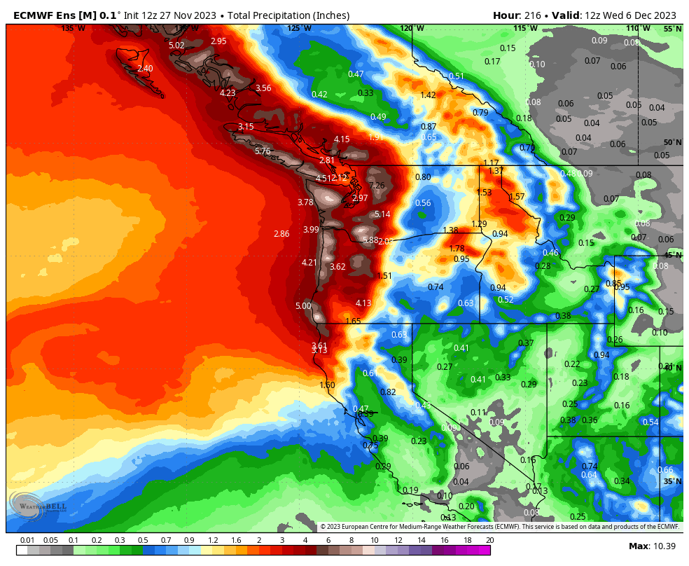
There could be some flooding issues early next week, but overall this will be a highly beneficial round of precipitation for the region.
If this wet period delivers as expected, the PNW should be fairly close to seasonal rainfall and snowfall averages in about 10 days from now.
