

It didn’t take long for the PNW to experience what will likely go down as one of the most eventful weather weeks of 2024. As of Monday evening, the NWS Seattle homepage is full of a long list of weather warnings and advisories. The blizzard warning for the mountains is the first one issued by NWS Seattle since 2012.
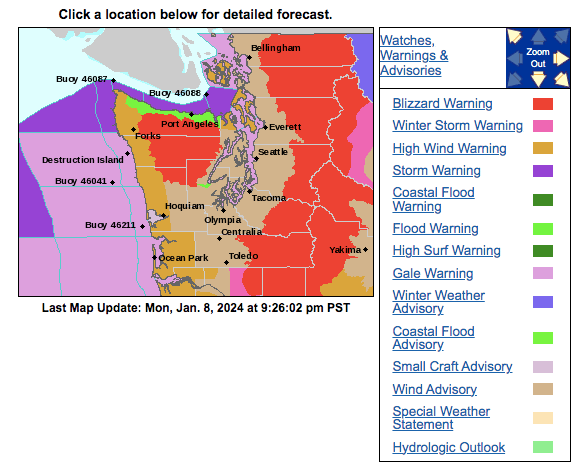
The culprit is a rapidly-deepening low pressure center that is currently making landfall near the northern tip of Vancouver Island with a central pressure in the upper-970s hPa.
This storm will be accompanied by unusually cold air in the postfrontal sector on Monday night into Tuesday, along with a “sting jet” consisting of strong westerly winds on the backside of the low pressure center.
This is not a storm to take lightly — travel in the mountains will be nearly impossible on Tuesday afternoon. Winds in the lowlands will be strong enough to cause isolated power outages.
In addition to all of that, snow levels are also expected to drop down to about 500 ft by early Wednesday, although precipitation amounts will be light for the most part. The I-5 corridor between Portland and Olympia has an elevated chance of seeing a few inches of accumulation in this timeframe.
Arctic air arrives late Thursday into Friday
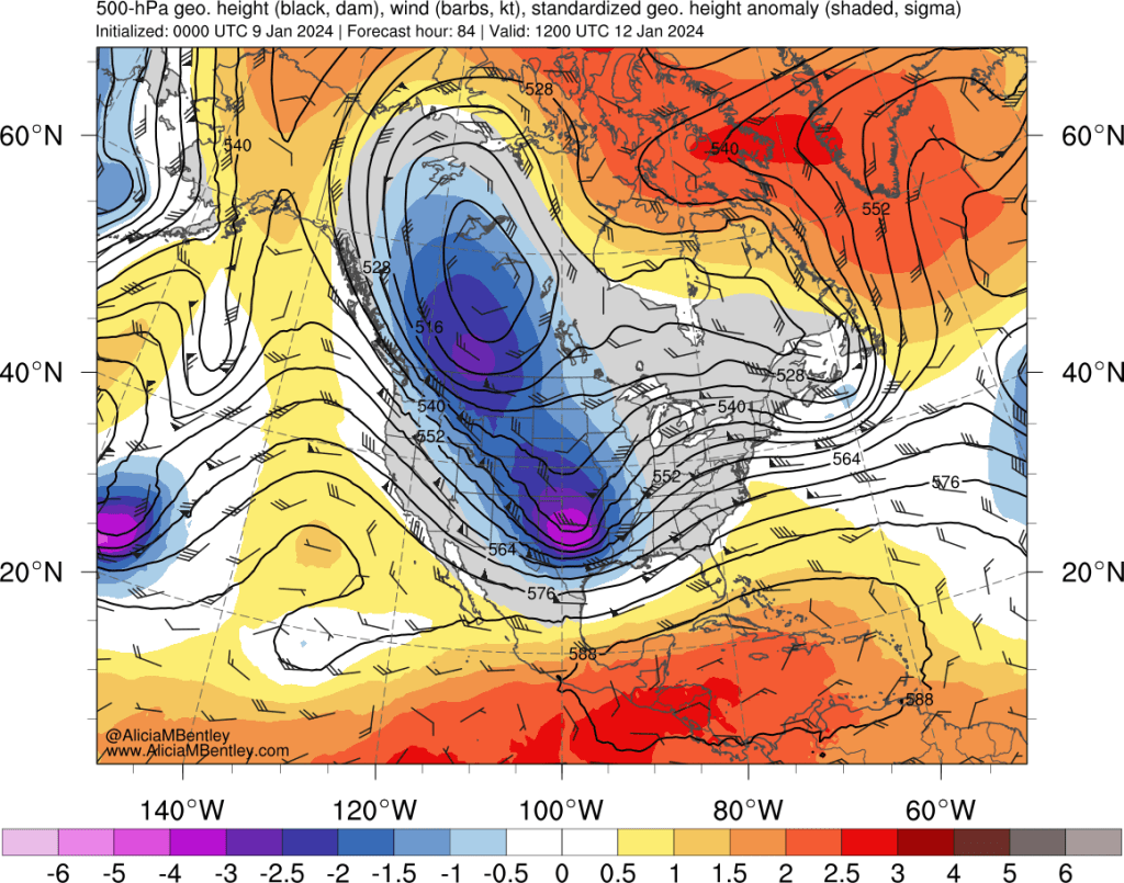
The much anticipated arctic front is expected to move from the Fraser gap southward into western Washington on Thursday evening. Frankly, weather models have been all over the place with the strength of this arctic airmass and even at a 3-4 day lead time they have still not settled on many important details. There are a number of reasons for the uncertainty, but it can be summed up as (1) it’s an extremely cold airmass; and (2) it’s a glancing blow.
Here are the GFS forecast synoptic maps for early Friday morning, first the 500 hPa height anomaly:
And the accompanying 850 hPa temperature anomaly:

One can observe that the 500 hPa trough is centered farther to our east than we would normally like to see for an arctic outbreak west of the Cascades, with the lowest heights over Alberta and northern Montana. The cold air at 850 hPa is extremely cold — 4 to 5 standard deviations below normal. By Saturday the trough will likely progress eastward, but arctic air will be firmly entrenched across much of Washington and northern Oregon.
Just to give you a sample of how cold it might be, here is a map of the forecast surface temperatures from the latest ECMWF run for Saturday morning:
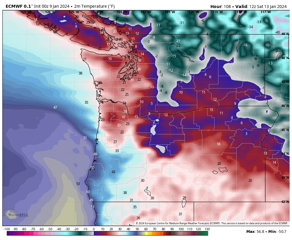
Widespread teens and low 20s are likely in western Washington, while temperatures will drop well below zero F in northern and northeastern Washington.
The big lingering question mark is how far the arctic air will penetrate into southern and southwestern Oregon. Which is important because of what will follow the cold air this weekend…
Snow and ice storm potential on Saturday
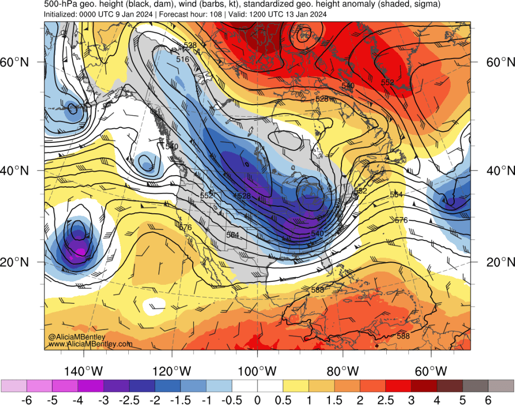
Extended cold and snowy periods in our region are always accompanied by a strong “blocking” ridge of high pressure over the northeast Pacific and Alaska. This will not be one of those type of events — the blocking is expected to break down almost immediately and a storm system will likely approach the PNW directly from the west from late Friday into Saturday. The small area of low pressure can readily be seen off the coast in the 500 hPa GFS forecast below for Saturday morning.
There is high confidence that a low pressure center will approach the PNW this weekend, but there is extremely low confidence surrounding the details of where the storm will actually go.
The GFS and most of its ensemble members have been increasingly confident the low pressure center will approach Cape Flattery, which would result in a messy overrunning event for NW Oregon and western Washington, including the Portland and Seattle metro areas. A snapshot of the precipitation type forecast on Saturday morning snows snow, sleet, freezing rain, and rain, depending on location. Under this scenario, the Seattle metro area would see a significant snow+freezing rain event, while Portland would see freezing rain changing to rain.
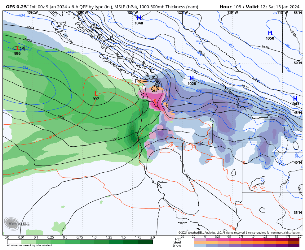
In contrast, the ECMWF and most of its ensemble members have been increasingly confident that the low pressure center will approach central or southern Oregon. Under that scenario, most of the precipitation would stay to the south of Seattle, while Portland would get hit with a major snow and freezing rain event.

I have no idea which model will be right or if the final result will be somewhat of a compromise between the two. Personally, I think the ECMWF scenario with a slight adjustment northward remains most likely at this time, but nobody really knows for sure.
The good news for snow lovers is that most areas will see snowflakes at some point this week as the arctic front passage on Thursday into Friday will likely be accompanied by some snow showers as well. And our mountain snowpack will be much closer to normal by next week.

Waiting for it to get above freezing in Bellingham. It has been below freezing for about 5 days. We set record low temperatures of 9, 3, and 7 on January 11, 12, and 13. This is pretty dramatic considering that many of the cold records go back to the 1950’s. This is the most intense cold snap we have experienced since moving to Bellingham 8 years ago. With the strong winds, our gas boiler was running at full tilt for a couple of days and was having a bit of trouble keeping up. When the winds moderated, things greatly improved. But on top of that, on Saturday, PSE experienced a complete loss of its major gas storage facility in Jackson Prairie in Lewis County. It is the largest gas storage facility in the PNW This caused PSE and our gas supplier Cascade Natural Gas to ask for gas and electricity conservation at the worst possible time. Luckily, PSE was able to put it back on line within a few hours. But this looks like a close call, as PSE natural gas is used for both heating and electricity generation. Here’s hoping the transition from the cold does not bring significant freezing rain. The current NWS forecast is not predicting much of that. As stated before, these cold events are very persistent and can bring freezing rain during the transition.
During some of the nights, my Davis weather station stopped transmitting. It depends on solar and backup battery, which temporarily stopped putting out enough power during the coldest periods. I have not heard much about disruption of the polar vortex and Rossby Waves. Would be interested in Joe’s take on this. Looks like the midsection of the US will get the brunt of this. If we experienced only a glancing blow, I am grateful it was not more.
LikeLike