

As we approach the halfway point of mountain snow season, snowpack remains in poor condition across much of the PNW.
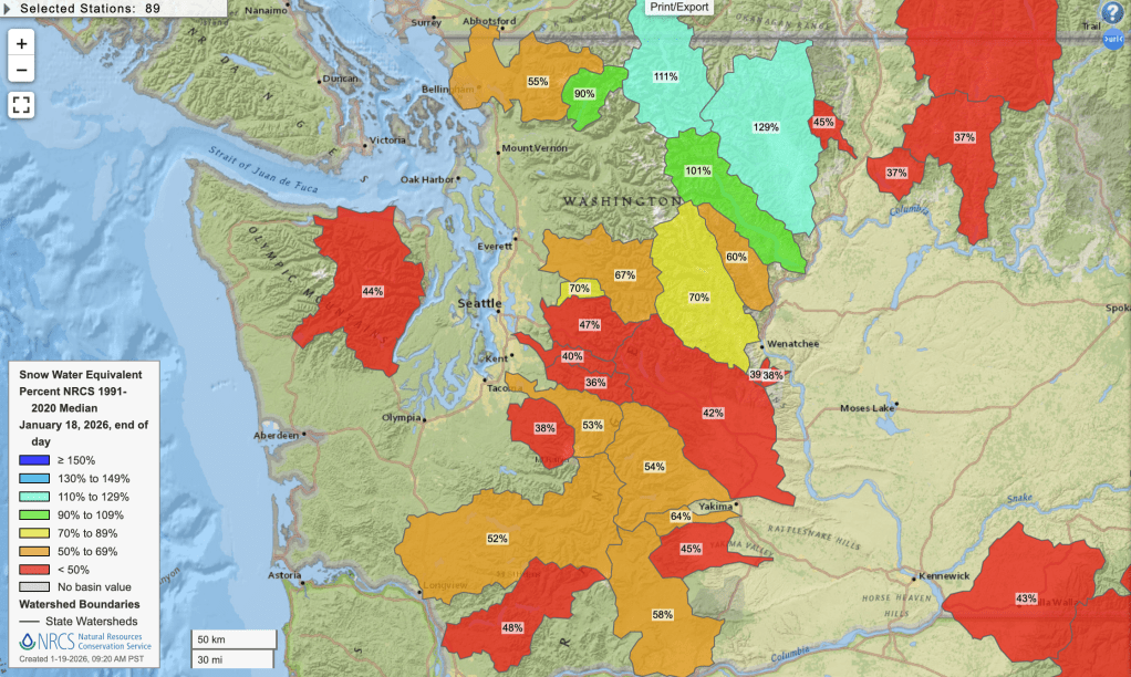
The state of the snowpack as measured by SNOTEL stations is often displayed as a ‘percent of normal’ relative to the 1991-2020 average. By that metric, portions of the North Cascades are running above normal, which the rest of the state is averaging around half of normal snowpack to date.
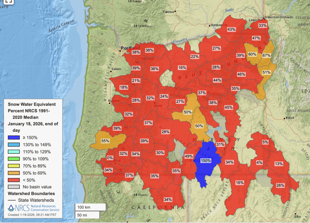
Oregon is far worse off, with most basins experiencing less than half of normal snowpack.
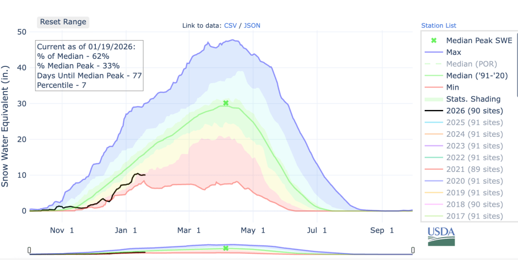
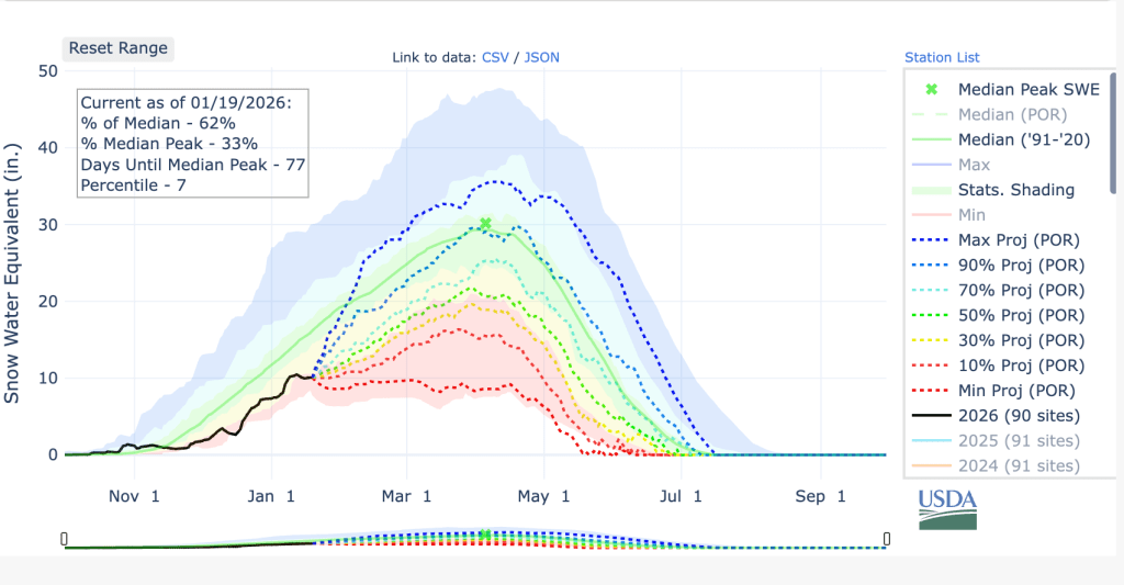
The National Water and Climate Center also has some nice graphics that average all of the stations together. Here’s the plot for Washington. As a whole, the state is at 62% of median snowpack to date, but that number is only the 7th percentile value for the date. That makes 2026 the third worst snowpack since 1985 as of January 19.
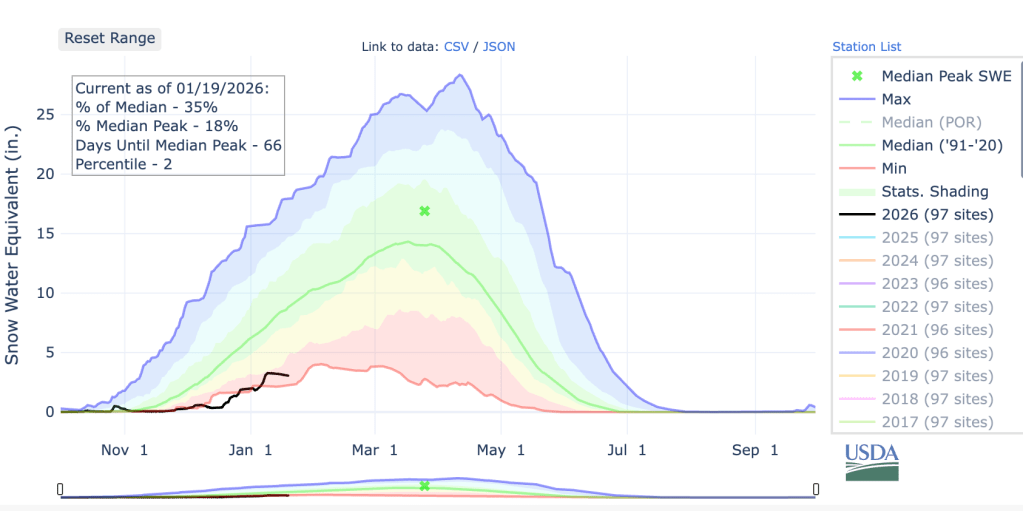
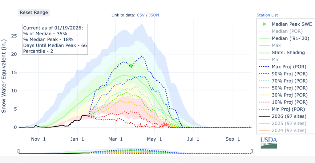
Oregon is at just 35% of median snowpack and ahead of just a single year, 1981. It is worth noting that 1981 is the first year in the database and is missing a number of observation sites, so I suspect that 2026 is in last place in Oregon.
Is there still time to get to normal?
Almost certainly not, the odds of finishing with a below-average snowpack are around 90%.
The projection for Washington for the rest of the snowpack season shows that 90th percentile is required from now until early April to reach a normal year. Projecting normal snowfall the rest of the winter (the green dotted 50% line in the plot blow) would leave Washington at about 70% of normal snowpack for the season. However — a 70% of normal snowfall is barely above the 10th percentile of historical years, represented by the red-yellow shaded boundary in the plot.
Oregon’s projection plot looks slightly worse, with a normal remainder of the year (green dotted line) projecting out around the 15th percentile of historic years.
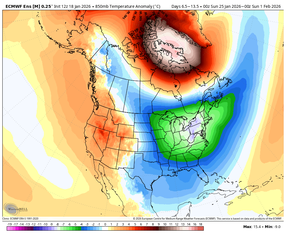
No sign of appreciable snowfall in the next two weeks
If we want any chance at recovering to a decent snowpack, we need the weather to turn around quickly. There is no sign of that happening in the next two weeks. Some precipitation will finally return by the end of the week, but temperatures will once again be well above normal.
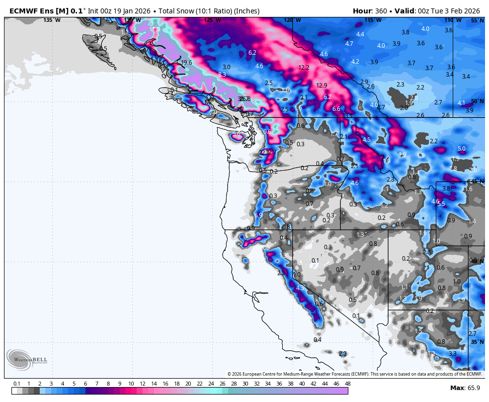
As as result, the EPS ensemble mean projected snowfall for the next 15 days shows that any decent snowfall is expected to be limited to the higher elevations of the north Cascades and Olympics.
La Niña on the way out
The above snowfall statistics are especially bad in light of the La Niña conditions that have been in place this winter. La Niña winters commonly deliver cool temperatures and above-normal snowfall in February and March, but recent sea surface temperature (SST) anomaly analysis show temperatures approaching normal in the equatorial Pacific.
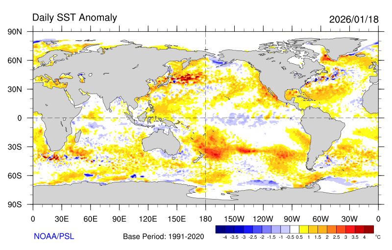
A flip to an El Niño is currently the most likely scenario for 2026-27. The next El Niño will smash global temperature records.

Quite the La Nina year. Great job by completely missing the boat NOAA. 🤣😂
LikeLike
This has been striking, particularly the anomalous conditions for a La Nina period. Would be interested in explanations for this.
LikeLike
Thanks for the information, Joe. Indeed, and I believe Jim mentioned to Cliff that, yes, precipitation has been above normal in many areas, but the lower elevation snow pack east of the Cascades is below normal. In considering the importance of the lower elevation snow for water rationing in the Yakima River Basin – it used to be (before I got out of the business) – that the Yakima Burec tried to hold off releasing water from the Basin’s 5 reservoirs until the middle of June, hoping that runoff from the lower elevation snowpack would meet the needs of irrigation requirements until that time.
The 5 basin reservoirs used to hold approximately 1 million acre feet of water. Not all of it was able to be drained for irrigation needs, but the storage in the reservoirs served to meet the needs of the Basin’s water users for the rest of the year after the middle of June. (With no rationing being needed for the junior water districts if they were full at that time.) User requirements at that time was approximately 1.8 million acre feet for the year for irrigation needs to avoid rationing to the junior water districts. Thus, you can see that – even if we have had above normal rainfall to date , and the reservoirs are filling- it greatly depends on how the precipitation falls. Rain, obviously, will run off after the ground is saturated. It may fill the reservoirs, but unless there’s a good snowpack below about 4000 feet to run off before the middle of June, trouble could occur later in the year. It will be interesting to see how this turns out, but I believe you have pointed out how close we may be to not have sufficient water to meet all the user’s requirements this coming growing season.
Thanks again!
LikeLike
Well…let’s just say, if the forecasted El Nino is even close to as accurate as the forecasted La Nina, I would expect completely the opposite to happen. 🤣
LikeLike