

It was only a matter of time. With a number of moderately-sized wildfires present across the region and no widespread rain in sight, major population centers west of the Cascades have been reliant on onshore flow to keep smoke intrusions to a minimum.
The overnight marine push signaled a change in the weather pattern that will end the run of largely clean air across western Washington and Oregon (excluding local spots close to fires that have already been experiencing “smoke season” for weeks).
The upper-air pattern as of Friday afternoon shows broad troughing over the PNW and an area of low pressure offshore of southern California. At first glance, this pattern does not look favorable for a smoke intrusion, although stronger winds associated with last night’s marine push have helped fan the flames of existing fires.
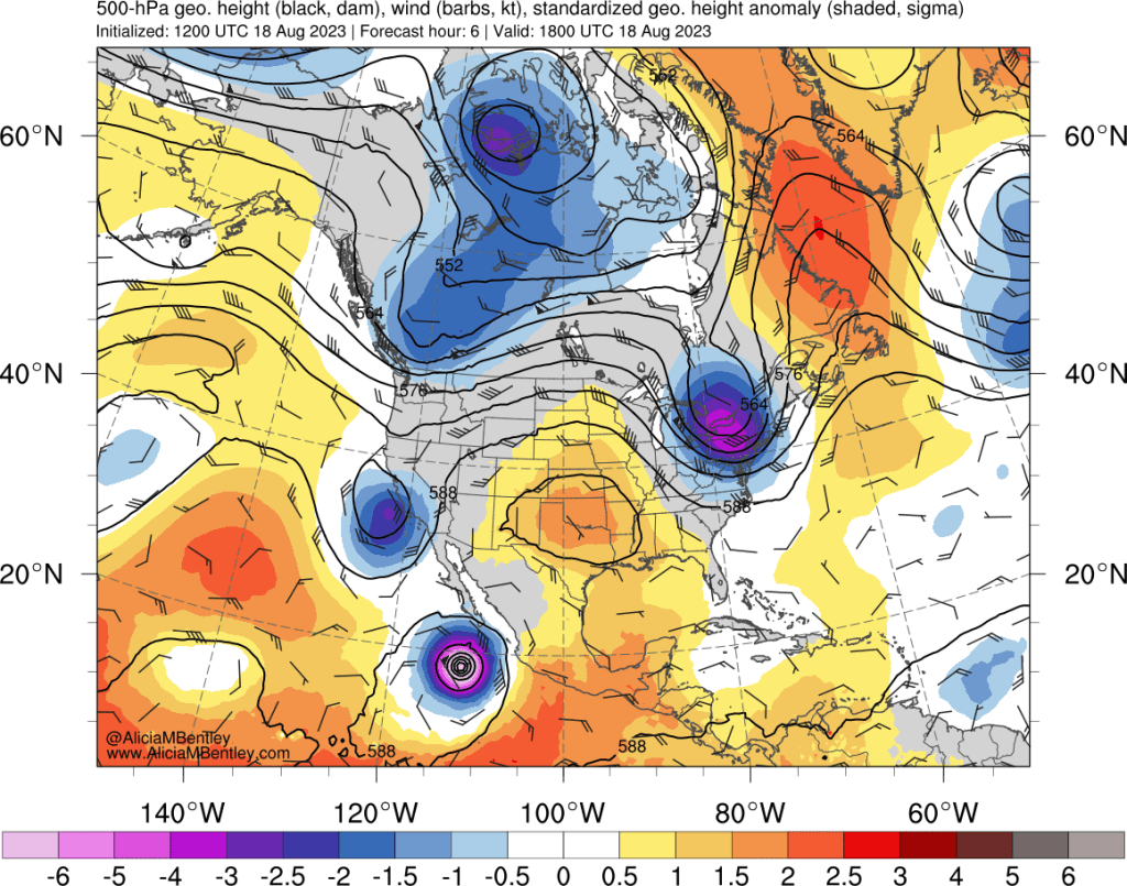
By Saturday afternoon, the trough over the PNW is expected to progress westward, leaving the PNW in a weak flow regime. Meanwhile, hurricane Hilary will began transitioning into a potent extratropical cyclone that will cause serious and potentially unprecedented flooding issues in southern California.
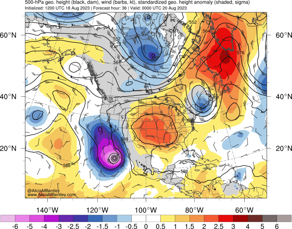
Within the quiet zone of the PNW, low- and mid-level flow will turn northeasterly just long enough to pull smoke down from southern British Columbia and into the PNW. Here’s the HRRR’s depiction of the evolution from late Friday evening through Saturday night.
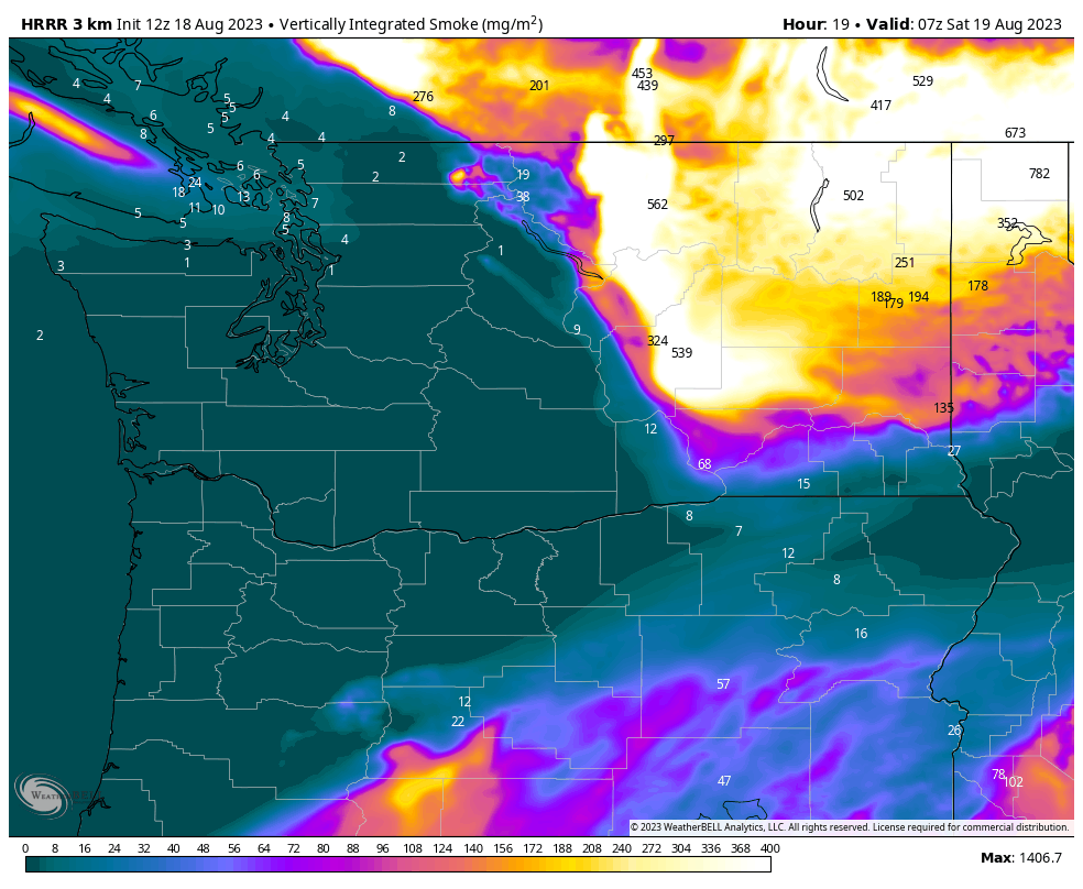
Unfortunately, this smoke will be in the lower levels of the atmosphere, so air quality will be impacted immediately upon arrival, by Saturday afternoon.
How long will the smoke be around?
The forecast beyond this weekend doesn’t look much better. The PNW is expected to remain under weak steering flow throughout next week. A few rain showers are possible as well. As of right now, any precipitation originating from the remnants of Hurricane Hilary is not expected to get any closer than Idaho and far eastern Oregon.
On Monday, an area of low pressure will approach the region and bring some temporary relief, especially to coastal areas. However, the low is expected to park in place for a few days, pulling smoke into its circulation and spreading it offshore across the coastal waters of the Pacific and eventually back around onto land.
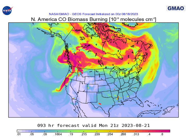
NASA’s Global Model and Assimilation Office (GMAO) runs the GEOS-Chem chemistry model on top of the GFS, allowing us to get a rough idea of what the smoke situation might look like next week. I’ve found that the CO BB (Carbon Monoxide Biomass Burning) product is a decent proxy for vertically integrated smoke.
By Monday, the smoke situation looks to improve west of the Cascades as another marine push moves in. However, low pressure centered around Vancouver Island is also expected to pull more smoke from BC westward over the Pacific.
By Tuesday, the smoke continues to travel counter-clockwise around the low pressure system, approaching the coast from the west:
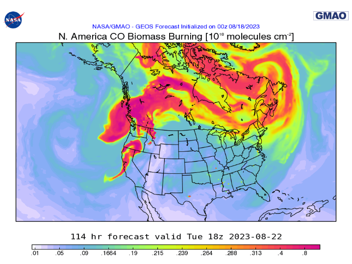
Next Wednesday looks the worst of all, with smoke fully entrenched just about everywhere.
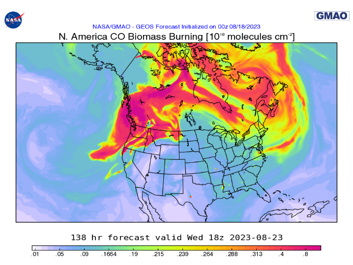
These longer-range forecasts should be considered very rough approximations, but it’s hard to see the smoke going away with weak steering currents expected to remain in place through the end of August.
In past years, we’ve seen that smoke is extremely difficult to clear out once it gets entrenched under the marine inversion on the west side of the Cascades.

Ugh! We knew it was coming especially with this hot dry weather stoking the fires. Glad I enjoyed the outdoors while the air was still clean. Hopefully we get rain… sometime 🙏🏻
LikeLike
It was inevitable given how dry it’s been. BLI in particular has been in the grips of unprecedented drought for most of the year and has received <9" of precip since January 1 – the driest calendar year to date on record by a wide margin (and the driest water ytd as well).
LikeLike
It’s crazy that the wettest day of the year so far at KBLI was in July.
LikeLike
It’s kind of flabbergasting when you put it like that! Hard to imagine that there are many (if any) other such occurrences in the POR.
LikeLike
Yes, it occurred on July 24, but until you mentioned it, I did not realize it was the wettest day of the year. Between July 24 and July 27, the BLI precipitation gauge was out of commission, so I am not sure where the NWS is getting its current .73″ estimate, which I think that might be a bit high. I am about a mile from KBLI and my gauge showed .60″ on that date. My gauge usually tracks fairly close to BLI (except when it snows). Given the unusual current projected path of TC Hilary, the ultimate impact of it on the PNW would seem to be very difficult to assess.
BLI is still very, very dry and we are now well under 50% of normal for the calendar year. Even with the one day of significant rain in July, the month as a whole was still below normal. I believe the last above-normal month for BLI was June 2022.
LikeLike
Apparently NWS Seattle determined that the 0.73″ reported on 7/24 wasn’t accurate as it’s been replaced by a big “M”. My backyard weather station is located SE of BLI’s ASOS by just about 2mi on the nose and my CoCoRahs gauge picked up 0.86″ that day. I typically measure more precip than BLI and the CoCoRahs total for the year currently stands at 11.34″. I also run VP2 tipping spoon and Rainwise rain gauges which have measured year to date precip totals of 11.89″ and 11.13″, respectively (the Rainwise gauge is almost always closer to the CoCoRahs than the Davis). In any case, there’s no reason to suspect that what BLI has reported is significantly more anomalous than locations within a mile or two of that site and it has most certainly been extraordinarily dry in Western Whatcom County for the past year or so.
LikeLike
Wonderful blog with excellent meteorological analysis. Thanks for sharing the truth while bloggers like Cliff Mass continue to share misinformation and downplay the upcoming smoke storm. His forecast was delayed and its still hilariously bad… he thinks its gone after Monday. Trying to pander to the anti-climate change cult. I do not care for any climate business, I just want accurate forecasts and thank you for providing one.
LikeLike
Hear, hear! Joe’s blog has raised the bar for PNW weather analysis and discussion into the stratosphere! Now we just need to browbeat him into posting more frequently 😉
LikeLiked by 1 person
A bit about Cliff Mass (from Wikipedia),
“Before joining the faculty of the University of Washington, Mass was a professor of meteorology at the University of Maryland from 1978 to 1981.[3] He leads the University of Washington Mesoscale Analysis and Forecasting Group and is the chief scientist of the Northwest Modeling Consortium. He has published over 120 articles in peer-reviewed scientific venues, and served on the board of over a dozen regional and national meteorological committees, conferences, and scientific journals.[7]
Do you have an evidence based example of the misinformation you think he’s been sharing?
LikeLike
Now that the smoke has cleared (at least temporarily), perhaps we should not put the host in the awkward position of having to moderate a Joe vs. Cliff preference debate.
https://www.weather.gov/wrh/timeseries?site=AV482
LikeLike
To be clear, I would defend Joe if someone on Cliff’s blog accused him, without evidence, of spreading misinformation.
LikeLike