

It’s been a while since the PNW had a high impact extreme weather event. Rainy season so far has been mundane, with near-normal precipitation and no cold air to speak of. Unfortunately, cold air will continue to be absent for the next week while it appears that major river flooding is possible in the Washington Cascades. Urban flooding will also be a concern in the lowlands, especially from Seattle southward.
Every atmospheric river event is a bit different, the main characteristics of the incoming one are:
- Long duration “family” of several consecutive atmospheric rivers (ARs)
- Pineapple express
- West-southwest orientation
- Centered roughly around the Columbia River (WA/OR border)
- Lack of snowpack increases runoff/flooding threat
Let me run through the details.
Long duration “family” of ARs
Atmospheric rivers tend to come in “families” when several consecutive storm systems form and propagate along a favorable jet stream. Sometimes these systems all make landfall in different locations, reducing the overall impact in any given location. Other times, like Thanksgiving dinner, you get the entire family showing up all in once place whether you like it or not.
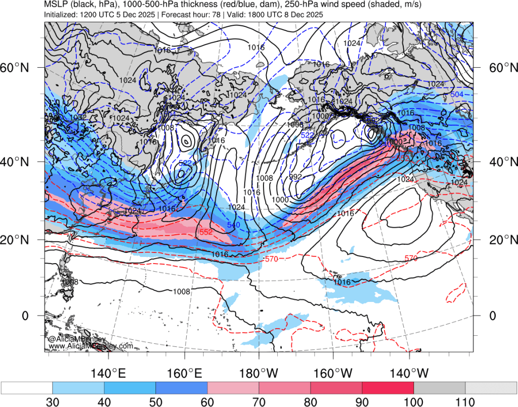
The key feature in the upper air (500 hPa) pattern (below) that will cause a family of atmospheric rivers to come knocking to the PNW broad but flat ridge centered just off the California coast by Sunday. This ridge will be in no rush to go anywhere, so every weather system for the next week will ride over that ridge and straight into the PNW.

As is apparent in the 500 hPa image above, there will be a strong jet stream directly between the trough over the Gulf of Alaska and the ridge to the south, providing plenty of energy to fuel a series of storm systems.
As a bit of an aside, the strong jet stream is likely fueled at least in part by anomalously strong convection in the equatorial western Pacific that has been ongoing for the last week or two. In more technical terms, the Madden-Julian Oscillation (MJO) has been in phases 6-7, which means the convection is centered around the Soloman Islands. Research shows that strong MJO in these phases is associated with an acceleration and extension of the subtropical jet stream, which eventually can evolve into extreme weather in North America.
Another feature that is readily apparent from the images above is the origin of the jet stream in the subtropical Pacific at around 20°N near the dateline. Not surprisingly, there will be a channel of subtropical moisture right along the trajectory of the jet, as illustrated by these plots of equivalent potential temperature (total sensible + latent heat content at 850 hPa) for Monday evening.

As I mentioned above, this whole pattern will basically be stuck in place for about 3 days. Here’s the same equivalent potential temperature plot 36 hours later, with the moisture stream still aimed directly at the Columbia River next Wednesday morning.

How many “members” will this AR family have?
In my opinion, there will be four distinct areas of low pressure that form and propagate along the quasi-stationary large-scale pattern.
The first is ongoing right now, on Friday Dec 5.
The second will be fairly weak and pass through on Sunday Dec 7.
Then the “main event” is a 1-2 punch of the third and fourth system, which are expected from Monday night through Thursday. Waves #3 and #4 will both be significant individual events, but the combination of the two is what could push this into major flooding territory.
The strength and timing of these events is important, because it impacts the category ranking that these atmospheric rivers are given, which is already making it into the news cycle. These categories are derived from an automated algorithm developed by the Center for Western Weather and Water Extremes (CW3E) based out of California. Part of the challenge here is whether the “1-2 punch” next week is classified as a single AR or as two separate ARs. Currently the GFS model classifies these as a single event (“B”), leading to a “Category 5” prediction.
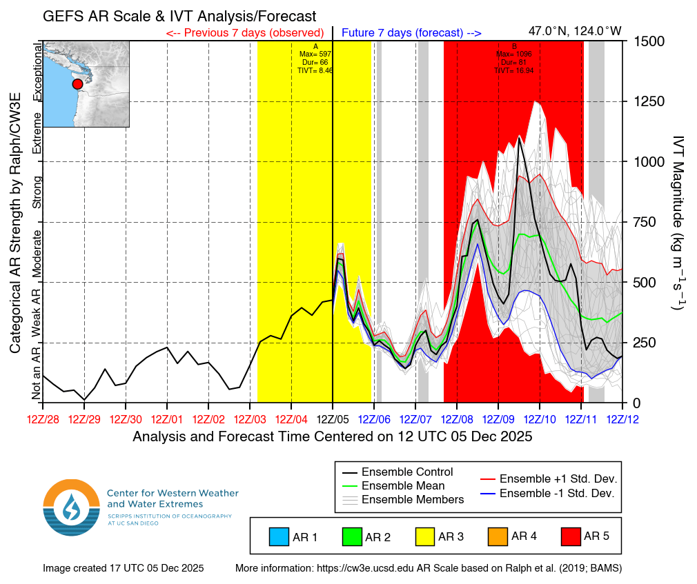
The ECMWF model shows two separate events next week (“B” and “C”), each of which are given a Category 3 rating.

In my opinion this is likely to be a high-end event worthy of a category 4-5 designation, but it’s important to keep in mind that these designations come from automated algorithms.
Rainfall and flooding
It’s too early to pinpoint the details of which area(s) will experience the worst flooding. AR events tend to target a specific river basin or two with the worst flooding, so a 20 or 30 mile deviation in the path could result in a different basin getting the worst of it.
The ensemble mean rainfall plots show widespread 10+ inch totals in the mountains through next Thursday, but once the exact track is nailed down I wouldn’t be surprised to see the unluckiest areas in the mountains hit 20 inches.

Even with appreciable rainshadowing, the Puget Sound lowlands will still see 3-5 inches of rain next week. Latest runs appear to show even higher totals in the Portland area.
Now is the time to make preparations for this event — clear out those clogged drains, gutters and downspouts now. Those in flood-prone areas should pay especially close attention to the forecasts this weekend.

A “category 4-5 AR” rain-on-snow event with 10-20+ inches of rainfall over normal mountain snowpack would likely increase the total amount of runoff as well as the runoff rate leading to even worse river flooding. Maybe other watersheds are somehow different but the occurrence of major flooding (23′ or more on the USGS gauge at Ferndale) on the Nooksack has historically been largely associated with exceptional rain-on-snow events.
LikeLike