

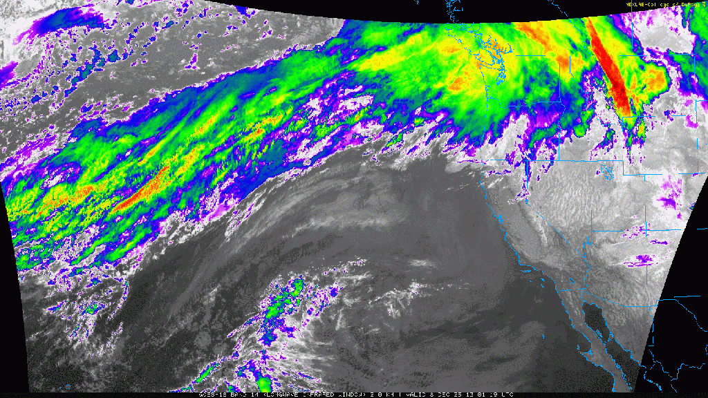
It’s hard to put into words how extraordinary the ongoing atmospheric river event has been for western Washington. A 72-hour IR satellite loop shows how a band of moisture originating in the subtropics remained in place for nearly four straight days. As of Thursday morning, precipitation is finally beginning to taper off.
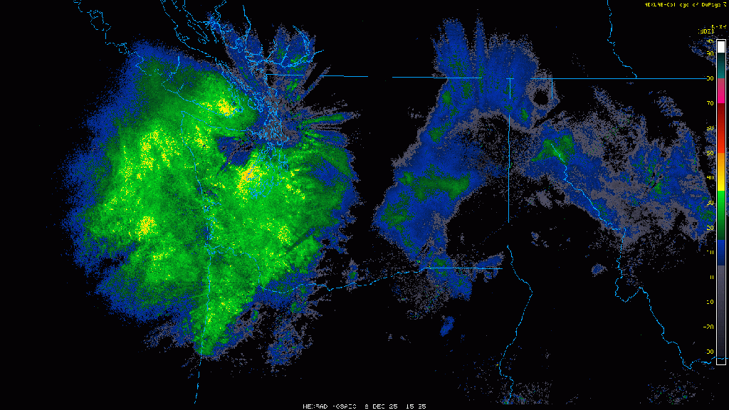
A radar composite over the same time period shows that besides a brief respite on Tuesday, precipitation on the windward slopes of the central Cascades was nearly continuous form Monday morning through Thursday morning.
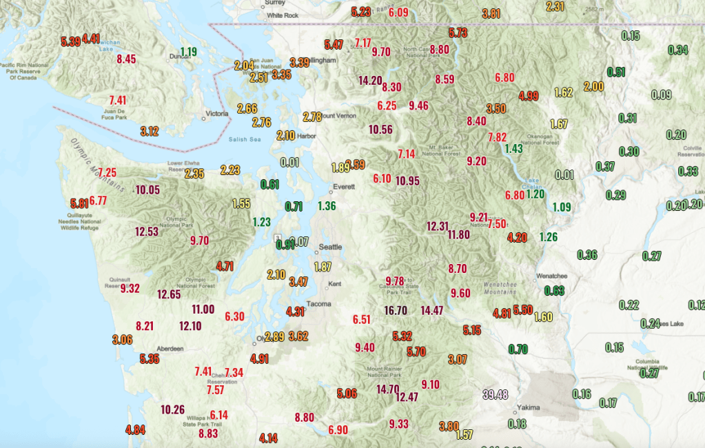
Rainfall totals over the same period have generally been in the 10-15 inch range on the windward slopes of the Cascades and Olympics.
Usually we would expect some of this rainfall to fall as snow in December, but snow levels have been above 7,000 ft almost everywhere except close to the Canadian border. There was also minimal existing snowpack to slow the runoff, so the response in river basins has been significant.
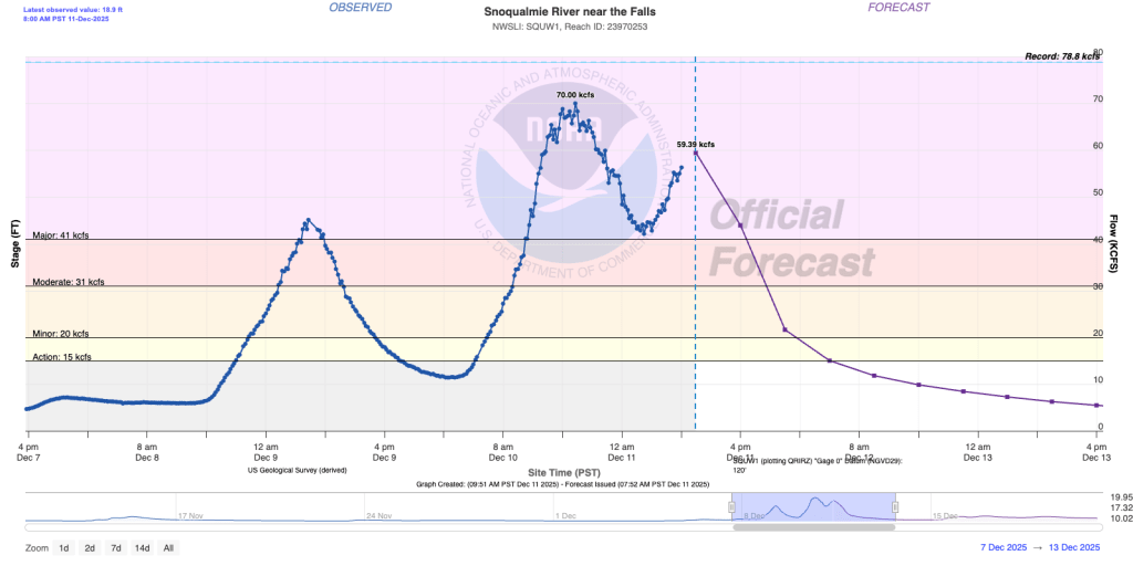
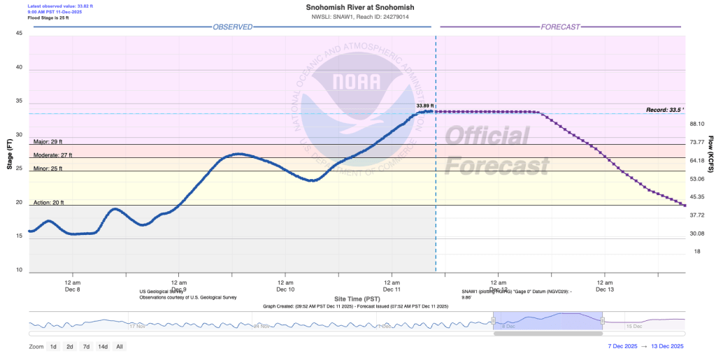
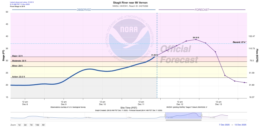
Three of the most-watched rivers have been the Snoqualmie, Snohomish, and Skagit. The Snoqualmie is seeing flooding comparable to significant events in 2009 and 2015.
The Snohomish will remain at record level (overtopping into a broad flood plain) for the next 36-48 hours.
The Skagit is of greatest concern because of the risk to people and property. As of Thursday morning, it is still expected to rise above the modern record.
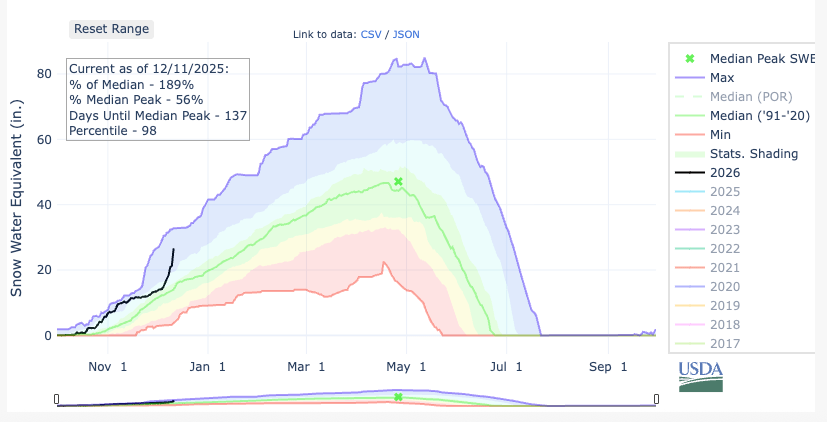
Almost no snow left in the mountains, with one exception
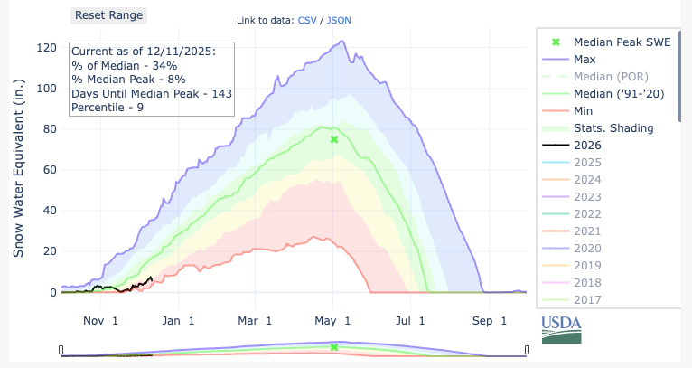
In many places, mountain snowpack has been essentially reset to zero by this event. The Waterhole SNOTEL (near Hurricane Ridge) is at a historic low.
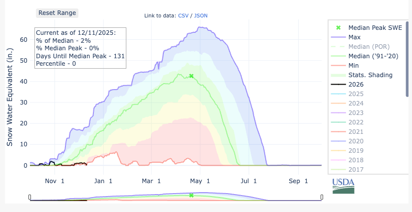
Paradise on Mt. Rainier is also in bad shape, 9th percentile relative to the historic record.
The one exception was near the Canadian border, where some cold air remained in place. Harts Pass in the North Cascades remained all snow for the entire event and is now in the 98th percentile relative to the historic record.
To me, the above plots perfectly encapsulate the impact of climate change on these atmospheric river storms. Temperatures and precipitation during major events are clearly increasing. In most areas, the result is a greater vulnerability to major flooding. In areas that manage to remain cold enough, snowfall can reach impressive levels.
It’s easy to imagine the same storm hitting 50-100 years ago, with less total precipitation but a much greater percentage captured as snowfall in the mountains.
When ocean temperatures along the entire fetch of the atmospheric river are 1-1.5 C above the 1990-2020 normal (and even more above the 20th century average), the result that we are seeing is not surprising at all.

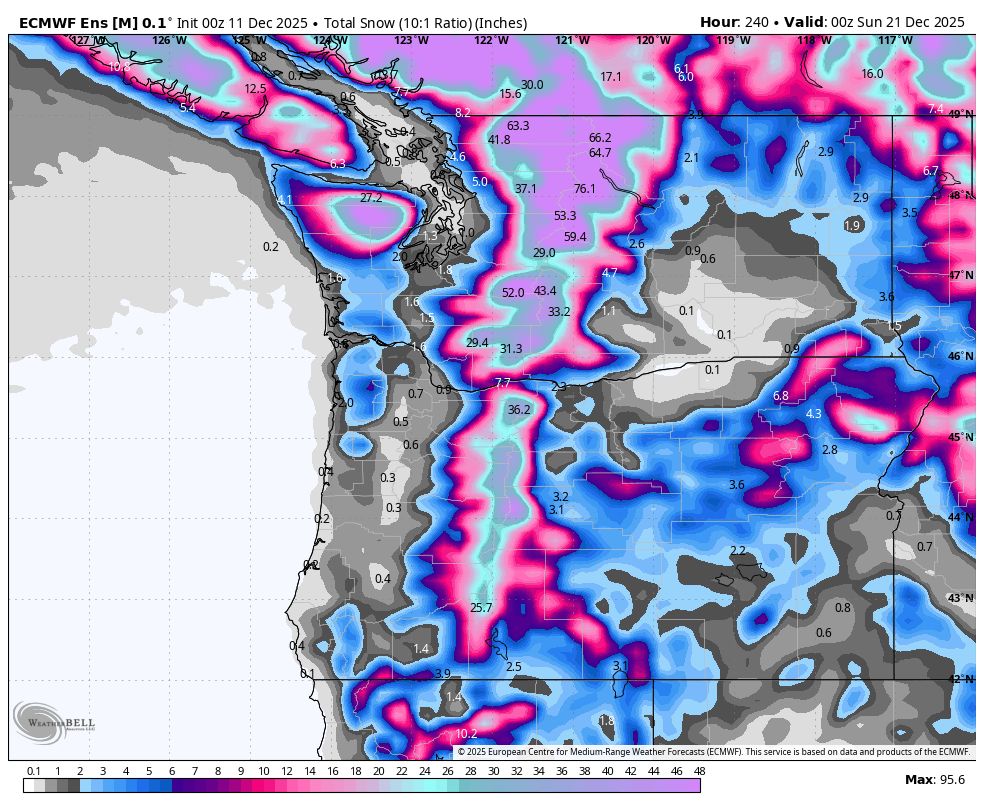
I’ll end on a bit of good news — snow levels are finally expected to come down next week with the active weather pattern continuing. So most ski areas will still be able to open prior to Christmas.

Thanks for this post, been very concerned especially about the folks living in the Skagit floodplain. The rainshadowing during this event is striking – 0.01 inches in Central Whidbey, just across the water from towns where record flooding is underway. Also, I think there may be an error – the rainfall total NW of Yakima probably not 39.48 inches. Really hoping that snow forecast for later this month pans out.
LikeLike
Oh yes I didn’t even see that total but definitely wrong. Usually the bad rain gauges read low rather than high (the 0.01 on Whidbey is likely wrong also).
LikeLike
Yes, seems wise to throw out the extremes on either end. Hopefully the rest of the month turns out to be less eventful, weather wise.
LikeLike
Hi Joe! Hey, if you’re interested in similar situations in the past, check out the Nov/Dec 1971 precipitation totals. In those days I would drive my VW bug over Snoqualmie Pass with a foot of snow on the road. The heaviest rainfalls were in Northwestern Oregon and southern WA, but I think it would be an interesting study. No significant real-time satellite information was available at that time, but what we did have was quite useful and allowed us to make decent forecasts.
And, if you’d REALLY like to look at a tremendous event, check back to the December 1964 storm that flooded just about ALL of Oregon and much of southern Washington and northern California. I got trapped in the northern Oregon Cascades for 3 days on that one while I was on leave from my base in southern California. Check the records for what Lake Shasta experienced from that storm, too.
Great to see you back on line!
Bud
LikeLike
Hey Bud! Hope all is well! Great anecdotes, I don’t know much about those storms, sounds pretty wild!
LikeLike