

Before I get into the details, here’s a summary of what to expect this winter in the PNW (December-February):
- Near-normal temperatures
- Above-normal precipitation
- Above-normal mountain snowfall
- Lowland snow in the Seattle area is more likely later in the winter (Jan-Feb) than early (Nov-Dec)
To set the stage for the forecast, I first want to quickly overview how seasonal forecasting differs from a standard weather forecast. Weather forecasts are derived from the current state of the atmosphere and provide precise, highly resolved details of the predicted weather for the next two weeks. Seasonal forecasts are derived from the average state of the atmosphere over a long period (usually 1-3 months). Most of the skill in seasonal forecasts is derived from anomalies in ocean temperatures. The state of the El Niño Southern Oscillation (ENSO) in particular is known to be highly correlated with winter temperature/precipitation anomalies in the PNW.

As the above diagram nicely shows, seasonal forecast skill is mediocre at best. The climate system is incredibly complicated and we have yet to figure out how to make consistently accurate seasonal forecasts. But that doesn’t mean we can’t try, especially in a year with a strong ENSO signal.
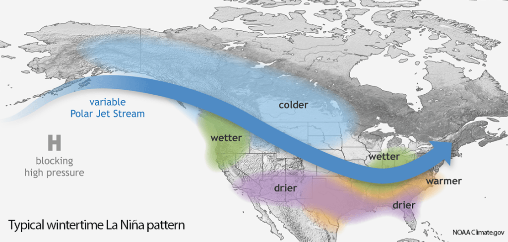
La Niña
As has been widely publicized, moderate La Niña conditions are now present in the equatorial Pacific.

Both statistical and dynamical model predictions strongly support continuing moderate La Niña conditions through the winter.

Historically, La Niña conditions are correlated with a persistent northwesterly jet stream bringing wetter and cooler than average conditions to the Pacific Northwest.
The historical relationship between ENSO and Seattle winter weather can easily be seen in scatterplots. These plots show the winter average multivariate ENSO index plotted against Dec-Jan-Feb observations at Sea-Tac. The year plotted is the year at the end of the winter season (Feb). While I’m showing plots for Sea-Tac, I also generated the same plots for Hoquiam, Everett, and Spokane and found similar trends.
All of the moderate to strong La Niña winters were characterized by near- or below-normal temperatures in Seattle. Only the weak La Niña winter of 2005-06 was above normal.

Winter (Dec-Jan-Feb) precipitation in Seattle is not as well correlated with the ENSO index. I was a bit surprised by this result given the PNW’s reputation for rain in La Niña winters. It turns out that La Niña rainy seasons are wetter than average, but the pattern does not seem to apply for the winter months.

How about lowland snow in Seattle? There is little difference between La Niña and neutral winters. Strong El Niño winters are bad news for lowland snow.

The combination of cool and wet conditions is a real winner for mountain snowfall. In the last 40 years, the four greatest snowfall seasons at Paradise (5,400 ft elevation on Mt. Rainier) occurred in La Niña winters. Lower-elevation mountain locations such as Snoqualmie Pass (3000 ft) tend to have a similar relationship.

To summarize, cooler and wetter conditions tend to be more common in La Niña years, but there is considerable variance in the data that is not explained by ENSO.
A unique aspect of fall 2020: the Pacific warm blob
La Niña is characterized by cooler-than-normal sea surface temperatures (SSTs) in the equatorial Pacific. The SSTs closer to home, in the Northeast Pacific, are not associated with ENSO. Looking at the November 1 global SST map below, a large ‘blob’ of 2-4 C above normal SSTs are present offshore. This ‘warm blob’ has previously made appearances in neutral and El Niño years (most famously from 2014-16, when state climatologist Nick Bond coined the name ‘blob’), but not in a recent La Niña year.

In fact, many of the recent La Niña years looked quite different. Here’s fall of 2017 (note slightly different color scale):

Fall 2010 (prior the winter labeled ‘2011’ in the scatterplots) was quite cold in the NE Pacific:

As was fall 2007:

Fall 1998 was closer to normal, prior to the record-breaking La Niña snowfall year at Mt. Baker:

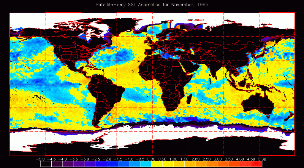
Fall 1995:
Fall 1988:

Eric Blake (NHC Sr. Hurricane Scientist) showed a direct comparison of 1985 vs 2020 SSTs, a great visual showing why we need to be careful when using La Niña analogs in an era of rapid climate change.
Another strike against comparing to the 1980s is that the 2020 Arctic sea ice extent is currently at a record low, ~40% below the 1980s average.
So what does this all mean for my winter forecast?
The combination of warm SSTs offshore and record low arctic sea ice suggests that winter temperatures will not be as cold as we would otherwise expect in a La Niña year. I am especially concerned that the warm SSTs offshore will limit lowland snow events in western Washington. However, lowland snow is nearly impossible to predict in a seasonal forecast and the warm SST blob may erode by mid-winter if an active storm track materializes as expected.
What do the models predict?
Several forecasting agencies also run low resolution seasonal forecast models out to 6 months in advance. These products have questionable skill–most famously they failed to predict the cold/snow of February 2019 beyond 2 weeks in advance. But when averaged over an entire season, a dynamical model should, in theory, be able to tell us whether the somewhat unusual SST pattern of fall 2020 will lead to a La Niña response in seasonal temperature and precipitation anomalies.
First, the NOAA CFSv2, which predicts below normal temperatures, especially in western Washington.

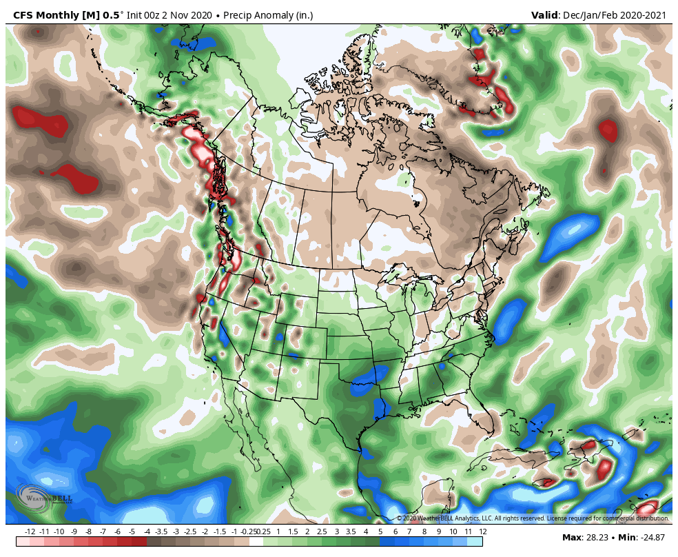
The CFSv2 precipitation output is a little harder to interpret generally shows drier than normal conditions:
According to the CFSv2, the cold+dry pattern is a consequence of a trough of epic proportions along the west coast of North America in January-February.
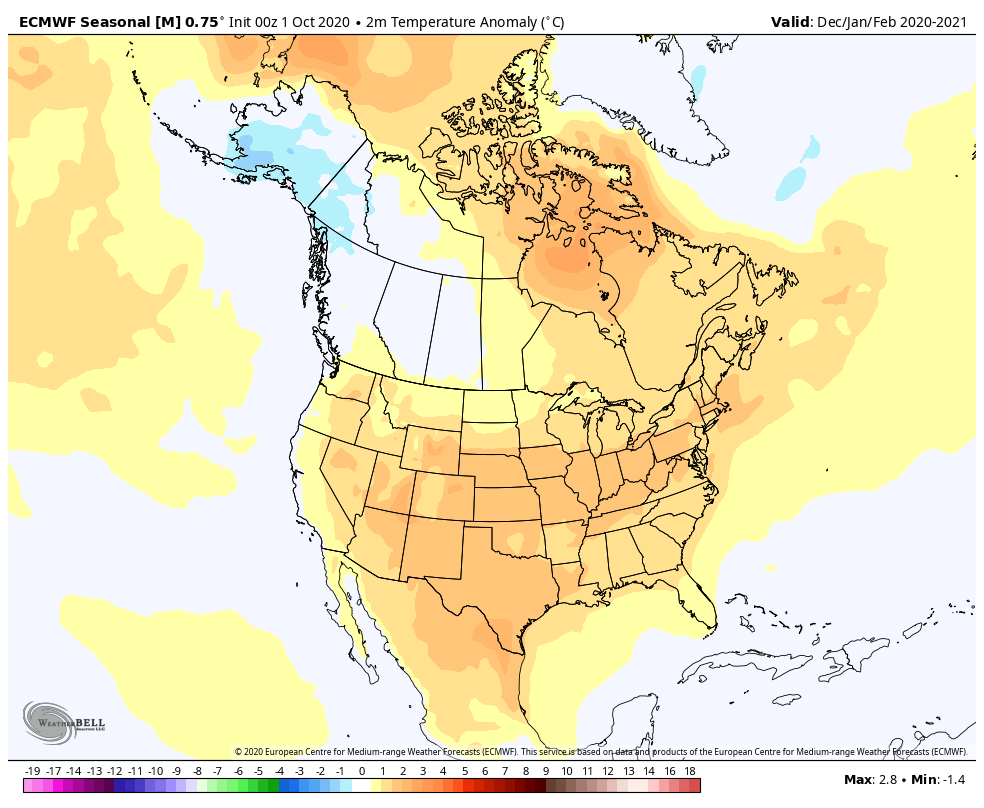
The ECMWF could not be any more different than the CFSv2. Above-normal temperatures nearly everywhere, including most of the PNW:
How about precipitation? Bring on the rain (and mountain snow):

If I had to choose between these two model forecasts, I would pick the ECMWF, which shows the expected La Niña precipitation response along with temperature anomalies that are consistent with the insanely warm northern hemisphere SSTs.
What is the official NOAA forecast?
NOAA’s probabilistic winter outlook is largely based on the expectation that La Niña conditions will dominate the mid-latitude weather pattern.
NOAA predicts higher odds of below-normal temperatures in the PNW, especially closer to the Canadian border:

As well as somewhat favorable odds for above-normal precipitation:

NOAA also predicts how drought conditions will evolve through the winter. Above-normal precipitation should yield improvement to drought conditions in the PNW. Unfortunately, the drought in California is expected to continue or worsen.

Summary
Putting it all together, my 2020-21 winter forecast for the PNW is fairly consistent with past La Niña winters, with a few exceptions.
Even with the unusual warm blob in the NE Pacific, it is expected that the mid-latitude jet stream will still respond to moderate La Niña conditions in the equatorial Pacific. There are currently ~85% odds that the ENSO index will remain firmly in La Niña territory through the winter. With La Niña continuing to strengthen it is possible that the ENSO index could further drop into the strong (-1.5) category.
I expect that the warm SST blob will be present at least through the first part of the winter, which will keep the overall winter temperatures near normal, especially west of the Cascades. Otherwise, a typical La Niña wet pattern with above-normal snowpack in the mountains seems like a good bet. Good news for skiers and drought relief in eastern WA/OR.
Predicting lowland snow around Seattle is generally beyond the capability of seasonal forecasts, but with obvious evidence of climate change in the global SST and sea ice anomalies, the odds of a marginal storm delivering 34 degree rain are becoming increasingly likely. Perhaps the randomness of the weather will deliver for snow fans.
Even though La Niña improves the odds of an accurate winter forecast, the science of seasonal weather forecasting remains inexact at best. So it will be fun to watch how the forecast evolves as we get closer to winter.
