

November is climatologically the wettest month of the year in the PNW and that has certainly been the case so far this month. Tuesday’s powerful cyclone, pictured below, capped off a impressive week with convective squall lines in the Seattle area, strong winds, high surf/beach erosion on the Pacific coast, and an early snowpack buildup that was enough to get Crystal Mountain open for skiing.
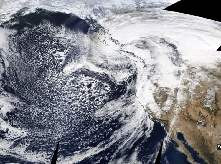
With minimum sea-level pressure near 962 hPa, the cyclone was not nearly as deep as category 4 Hurricane Iota in the Caribbean Sea (~920 hPa), but the scale of the cyclone (~1000 km) is an order of magnitude greater than a ~100 km hurricane.

However, the devastating timing of two consecutive major hurricane landfalls in Nicaragua has resulted in a humanitarian crisis requiring significant relief efforts. One way to help is to donate to a relief fund such as one set up by the Hispanic Federation.
Focusing back on the PNW, rainfall totals for November to date have been impressive, with most of the November precipitation falling within the past week (with the exception of a big storm on November 3).
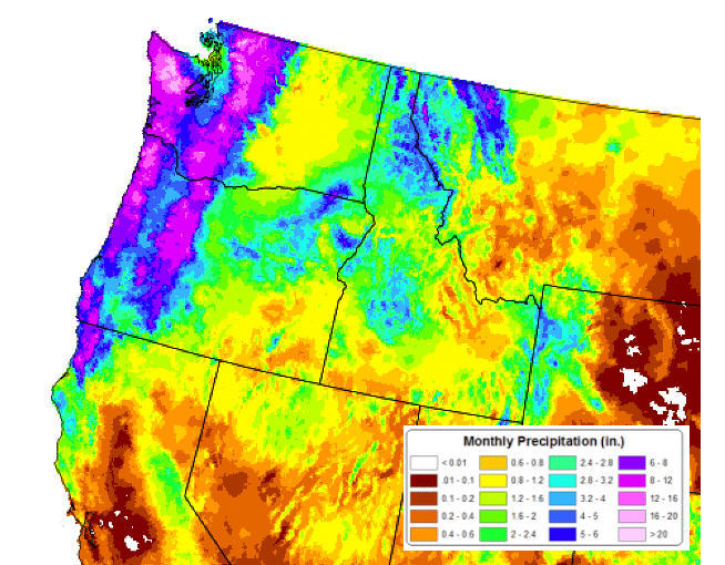
Precipitation anomalies within the past month are near to slightly above normal through the first 17 days of November. Pendleton, OR is already up to 2.28″ of rain in November, 150% of the average for the entire month. And regular readers of this blog already know that mountain snowfall is running well above normal.
So, that fairly long-winded introduction gets us to the main point of this post: will the stormy conditions persist for the next month (or longer)?
La Niña update
Last week the NOAA climate prediction center released an update on La Niña:
The latest forecasts from several models suggest the possibility of a strong La Niña (Niño-3.4 index values at -1.5°C) during the peak November-January season. The forecaster consensus supports that view in light of significant atmosphere-ocean coupling already in place. In summary, La Niña is likely to continue through the Northern Hemisphere winter 2020-21 (~95% chance for January-March)…
NOAA Climate Prediction Center, 12 November 2020
The strengthening of La Niña can be seen in the sea surface temperature (SST) anomaly plot below–particularly in the Nino 3.4 region which is the most commonly used metric (the center of the equatorial East Pacific).

The forecast of not just La Niña conditions but strong La Niña conditions gives high confidence that our November weather is likely a sign of things to come for the winter.
The rest of November
Both the ECWMF ensemble (EPS) and GFS ensemble (GEFS) agree that a largely zonal pattern can be expected for the rest of the month. The GEFS is shown below. Temperatures will likely be near-normal with this pattern.

Precipitation is generally expected to be fairly close to normal in the PNW with above-normal conditions favored in coastal BC and below-normal precipitation in California. Normal precipitation at the wettest time of the year means lots of rain in the PNW!

December 2020
Models are in fairly good agreement that December will be another stormy month. The ECMWF weeklies show more of the same for December, with anomalous troughing over Alaska/western Canada and zonal flow over the NE Pacific. This pattern usually brings near-normal temperatures.

Not surprisingly, above normal precipitation is expected with this pattern. Unfortunately, the model does not expect the wet conditions to extend down to central and southern California.

The GFS and CFSv2 show a similar pattern, although the CFSv2 is notably colder with a more prominent trough along the west coast of North America. The CFSv2 solution would suggest greater odds of lowland snow west of the Cascades, while the other models would more likely keep snow confined to the mountains.
The rest of the winter
Beyond December the seasonal climate models show less agreement, but if a strong La Niña is present it becomes increasingly likely that colder than normal temperatures will be present in addition to continued stormy weather. In other words, it’s very likely to be a great ski season.
