

Western Washington snow fans haven’t had much to cheer for yet this year, but weather models have hinted at at least a slight potential for snowflake or two on Monday Dec 21. On Saturday afternoon, NWS Seattle issued the following statement about the potential.
The NWS graphic suggests that snow will generally be confined to the mountains and foothills, with two possible exceptions:
1) The Pt. Angeles / Sequim area
2) The “convergence zone” area in northern King / southern Snohomish County.
What does the large scale forecast look like?
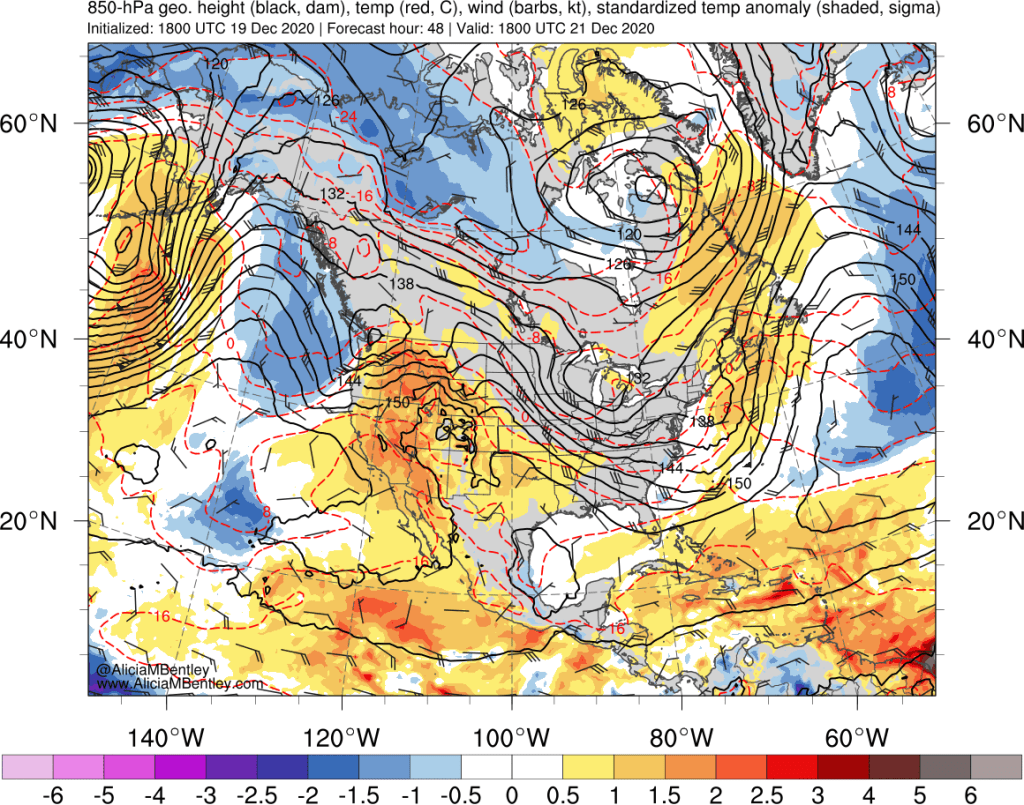
Unfortunately for snow fans, this is not a classic setup for a significant accumulating snow event. Our main cold air source is through the Fraser River gap in southern BC, so there needs to be arctic air around to be pulled through the gap by an approaching low pressure system. The 850 hPa temperature anomaly plot for Monday shows near-normal temperatures in the lower levels of the atmosphere, with slightly cold maritime air approaching from the ocean.
Another way to visualize the air source is to run back trajectories with NOAA’s HYSPLIT model. These trajectories end near the surface at Paine Field on Monday evening.

As you can see, the cold air comes from Siberia, passing over the entire North Pacific on its way to Seattle. This is a perfect setup to get lots of snow in the mountains, but the lower-level air tends to pick up too much heat from the Pacific Ocean on its journey to Washington State to keep temperatures below freezing right at sea level.
Another way to visualize the setup is using upper-level (500 hPa) geopotential height maps. Air flows roughly parallel to the height contours.

Clearly there will be a nice storm on Monday, as a potent trough can be seen directly over Washington. But when we compare the above map to an ideal snow setup (February 10, 2019), there are major differences.
Not only was arctic air already in place on Feb 9-11, 2019, but there was a continuing supply from the north. Most of the back-trajectories came from interior British Columbia and Alaska.
Ok, so it’s far from a perfect setup, but could we still get some snowflakes anyway?
Clearly the upcoming storm is going to struggle to deliver snowfall, but there are a few reasons to keep the dream of lowland (or at least foothill) snow alive.
First, Monday is the winter solstice. So the sun angle is the lowest of any day in the entire year. Less sun = less opportunity for the low-level air mass to be further warmed. And the main snow potential is after sunset on Monday evening.
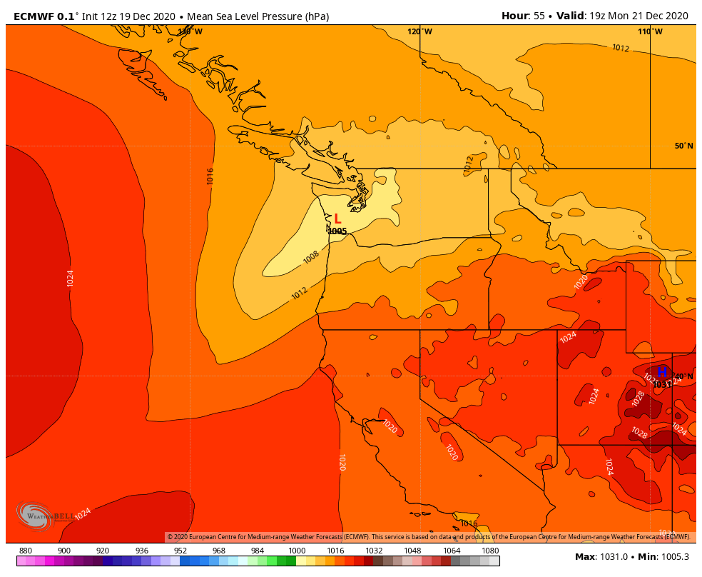
Second, a weak surface low might form and track across south-central Washington. Low pressure to the south of Puget Sound will help to draw colder air down from the north. This scenario was best depicted in the 12 UTC ECMWF deterministic run on Saturday.
Ensemble low positions show quite a bit of uncertainty with respect to the low track. Some of the members have the low right where it needs to be (tracking over southern Washington). Some have the low too far north. And another cluster has a low forming way to the south, which wouldn’t be good for snow either.

Again, with marginal temperatures, even a perfect low track might not be enough, but at least it offers the best chance of getting snowflakes down to the surface.
If we look at the ECMWF hourly precipitation type and low track forecast at 7 PM Monday evening, we see this ‘goldilocks’ scenario in action. Not only does the low track nicely across central Washington, but thanks to the upper-level support from that strong trough, a nice band of precipitation is present behind the low.

This would be a great scenario for snow in the Cascade foothills, places like Snoqualmie Ridge, North Bend, and Lake Stevens. Sea level will probably stay a bit too warm, but certainly the higher ridges would have better odds of seeing an hour or two of snow as the precipitation moves away, especially if the precipitation is on the moderate to heavy side.
Ultimately the high precipitation rates, which can dynamically lower the snow level, are the reason the models are showing more snow than we would expect with marginal cold air in place. The 6-hour totals from the ECMWF for 2 pm – 8 pm Monday evening are very, very impressive.

Over an inch of liquid equivalent in 6 hours! Is that realistic? Hmm…
What do the model snowfall forecasts look like?
Lets start with the perfect scenario from the 18 UTC ECMWF. The potential exists for a couple inches of snow, especially east of Seattle. Anywhere near sea level and near the water gets a few flakes but little accumulation (remember, these maps do not account for snow that melts when it hits the surface, which will happen initially).

Whatcom County and the Port Angeles area have the potential for higher amounts, but I wouldn’t read too much into that big number in PA (see below).
Is there ensemble support for these totals? Sort of. For Paine Field (below) less than half of the ECMWF ensemble members have more than a dusting of snow. Sea-Tac is similar–and remember, Sea-Tac is in a more favorable location for snow at 400 ft elevation than most of the city of Seattle.

The GFS ensemble suggests lower chances of snow than the ECMWF–Paine Field again pictured below:

What about that juicy snowfall forecast for Pt. Angeles?

The ECMWF is all over the place. But the ensemble mean is only 4 inches, and even that is likely optimistic.
Putting all of this together, what is the most likely scenario?
Snow is looking like a good possibility for the foothills to the east of Seattle and on the north slopes of the Olympic Mountains, especially above 500 ft elevation. Areas closer to Puget Sound in the 250-500 ft elevation range have a chance for a few snowflakes and potentially some accumulation on grassy areas–IF the more favorable model scenario plays out. The GFS also hints at a convergence zone, which could locally enhance totals if it forms. If you live near water or below 250 ft elevation, you might get lucky and see the first snowflakes of the year, but I wouldn’t expect more than that.
However, with the ongoing spread in the ensembles, there is still a good chance that the forecast will change. And you can bet that the Seattle weather community — professionals and enthusiasts — will be keeping everyone updated.
