

Seattle’s February snow pack is long gone, but there is still plenty of snow to be found in the mountains. They got a help from the storm track last month, which was well positioned to blanket Washington and northeastern Oregon with precipitation.
To get an idea of the shape of the storm track I’m showing the mean 500 mb geopotential heights and anomalies from the NCEP/NCAR reanalysis for February 2021. If you haven’t looked at a plot like this before, image storms being “steered” along the colored contours. These plots highlight a highly angled storm track which channeled one winter storm after another over the northwest. For comparison, the January plot would have favored tracking Pacific storms northward towards Canada.

The geopotential height anomaly plot details how unusually tilted this storm track orientation was. The yellow areas over the Pacific indicate higher than normal heights, while the blue area over North America indicate lower than normal heights. While February is frequently a stormy month, we had more favorable conditions than usual for storms to pile snow on the Pacific Northwest.

The results of this storm track are reflected in the snow water equivalent (SWE) snapshot from early March. SWE is well above average over Washington, northeastern Oregon, and northern Idaho. It is closer to median over the rest of the northwest, with the driest basins found in southern Oregon and Idaho.

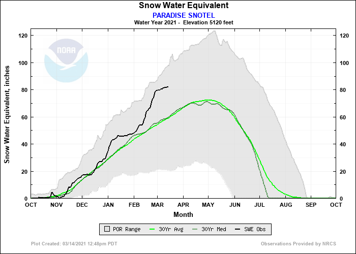
We’ll take a look at a daily SWE plot next that shows how consistently stormy things were in the mountains throughout February, using the Paradise SNOTEL site as an example. SWE increases dramatically at the start of the month with a steep trend that persists until the last few days. In all, nearly 40% of the SWE total measured March 15 at Paradise accumulated between February 1 and March 1. This February surge is visible in SNOTEL data throughout the Cascades (for example, you can also investigate Stevens Pass or Mt. Hood), though higher elevation areas in the North Cascades received notable snow in January as well.
Since late February there has been a distinct plateau in SWE, albeit at amounts that are much higher than the median (Paradise is at 138% of median). Even if snow building is unimpressive over the rest of the spring, it looks like the Cascades (along with a few other ranges) will enter the summer with plenty of moisture in reserve.
There are some indicators that more snow may be on the way. The short term outlook from the Climate Prediction Center shows wetter conditions may be coming over the next week for the northwest. Temperatures are likely to be average for the Washington Cascades, but a possibility of colder and wetter weather for Oregon could help snow pack in the southern and central parts of the state catch up.


Indeed, there’s snow in the weekend forecast for Washington and Oregon passes, albeit with smaller accumulation amounts predicted than we saw for most of February’s events. It looks like winter is winding down.
