

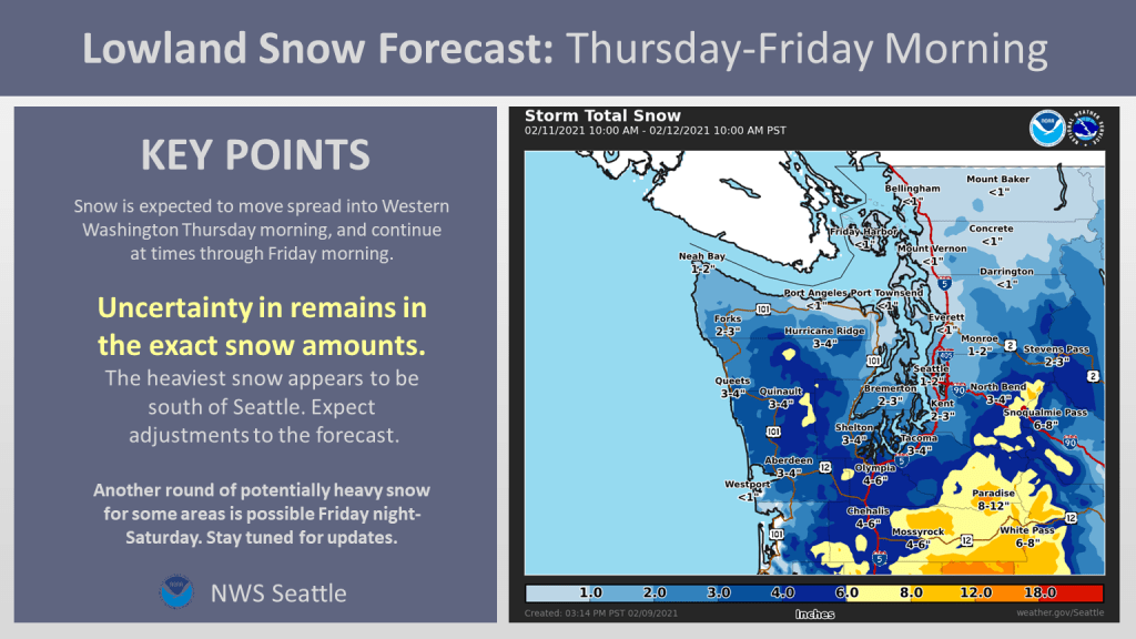
This is the real deal, a significant 1-2 punch snowstorm is headed for the Seattle metro area beginning Thursday and continuing into Saturday night.
Significant snowstorms are extremely rare in Seattle because it is nearly impossible for a storm system to combine cold, arctic air from east of the Cascades with warm, moist maritime air from the Pacific Ocean. This setup has both.
Arctic air (850 hPa temperatures below -15 Celsius) is currently covering nearly all of southern Canada and the northern US.
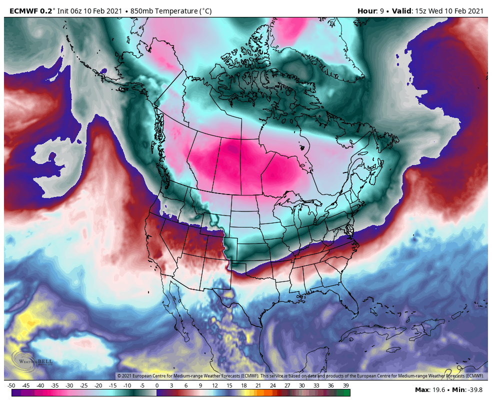
Cold, arctic air is dense and has high surface pressure. By Thursday morning the sea level pressure will be 1050-1060 hPa across interior BC and Washington.

Meanwhile, a ~1004 hPa low pressure system will head for the northern Oregon coast on Thursday. The strong pressure gradient through the Cascade and Fraser gaps will pull a continuous supply of cold air into the region, while the low pressure system and associated fronts will supply the moisture and lift needed for precipitation.
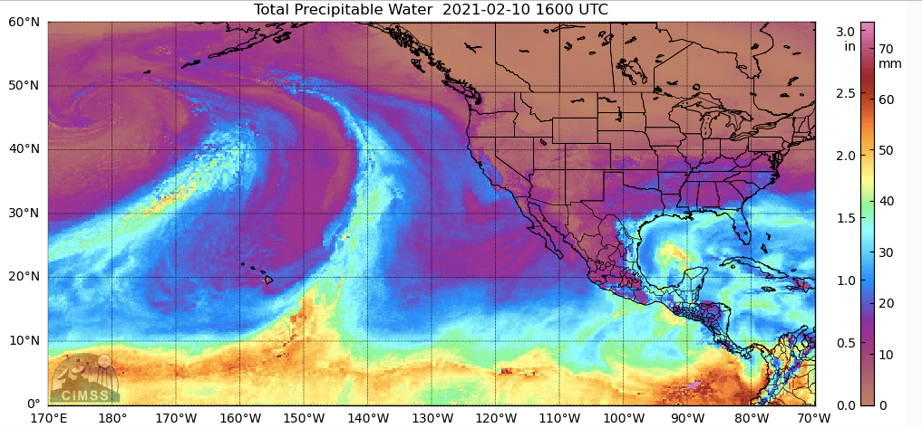
Speaking of moisture, the latest satellite-based precipitable water image shows two impressive corridors of subtropical moisture in the eastern Pacific associated with the two areas of low pressure that our headed our way
So this is going to be an exciting couple of days. Lets take a look at some of the details and remaining uncertainties in the forecast.
When will the snow start?
South of Seattle the snow might get going as early as Thursday afternoon/evening in association with the first area of low pressure. However, the models are still not in very good agreement about where the northern extent of the snowfall will be on Thursday into Friday morning.
The official forecast from NWS Seattle is a good blend of the various model guidance, with 1-2″ of snow possible in Seattle by Friday morning.
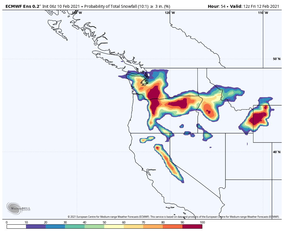
The European model shows how the odds of 3″+ of snow by Friday morning decrease the farther north you go.
It is also possible that the snow will hold off entirely until Friday afternoon in the Seattle area if the first low ends up coming in near the southern end of model guidance.
When will the heaviest snow hit?
Friday afternoon to the south of Seattle and Friday evening in the Seattle area. The moderate to heavy snow will continue into Saturday morning.
Here’s an example of 3-hour snowfall rates from the ECMWF from 10 pm Friday – 1 AM Saturday near the peak of the storm.
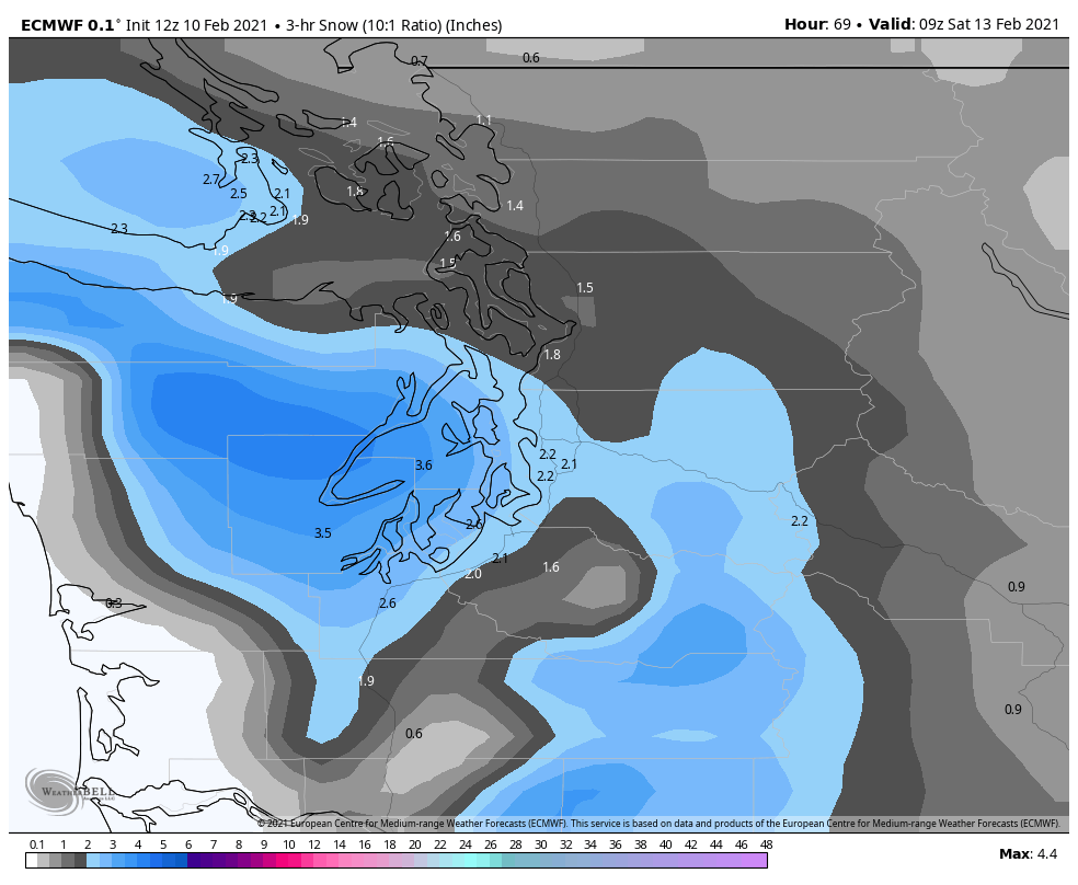
Nearly 1″ per hour snow rates at this time. Wow! Plus it will be happening at night so there will be no help from the sun to melt the snow off of road surfaces.
What is the range of forecast snowfall totals?
Uncertainty remains quite high. Storm total snowfall in Seattle could be anywhere from ~5 to 15 inches, which is why the Seattle NWS office and other media outlets have been reluctant to raise the alarm about a historic event.
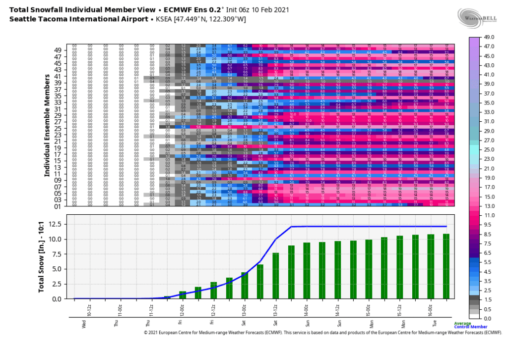
Both the ECMWF and GFS deterministic runs are showing big numbers as of midday Wednesday. Here’s the ECMWF total as of Saturday evening, with a 10:1 snow:liquid ratio. The final ratio might end up being closer to 12:1 or 15:1 so you can see how impressive the snowfall amounts could be.

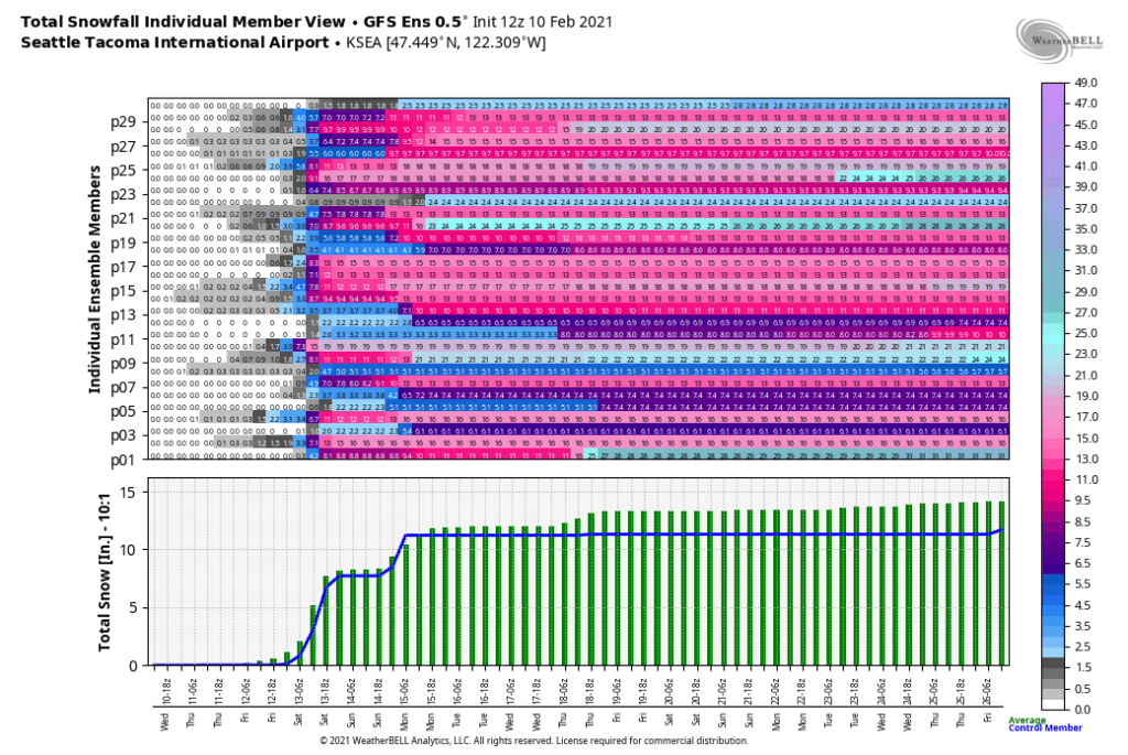
The GFS is a bit farther south with the heaviest snow, but Seattle still is in line for 8″+ under this scenario (10:1 ratio). Plus, the colder temperatures in the GFS means the snow:liquid ratio would be closer to 15:1, meaning Seattle would still probably approach a foot of snow.

Additionally, the colder GFS hints at even more snow on Monday, while the warmer ECMWF suggests it will be raining in the lowlands by Sunday.
What about the ensemble spread? The ECMWF ensemble mean is a bit lower than the deterministic run, with around 8-10″ by Saturday evening.
Both the GFS deterministic and ensemble mean are around 8″ for Seattle (10:1 ratio), plus additional snow on Sunday night into Monday.
Even the low end of the ensemble envelope suggests 4-6″ of snow in Seattle. So there’s no avoiding a high impact event.
Looking at the spatial distribution (ECMWF and GFS odds of 6″+ by Saturday night) confirms that regions south of Seattle have the best chances for big snowfall numbers.
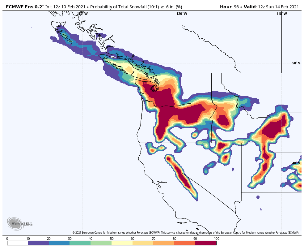
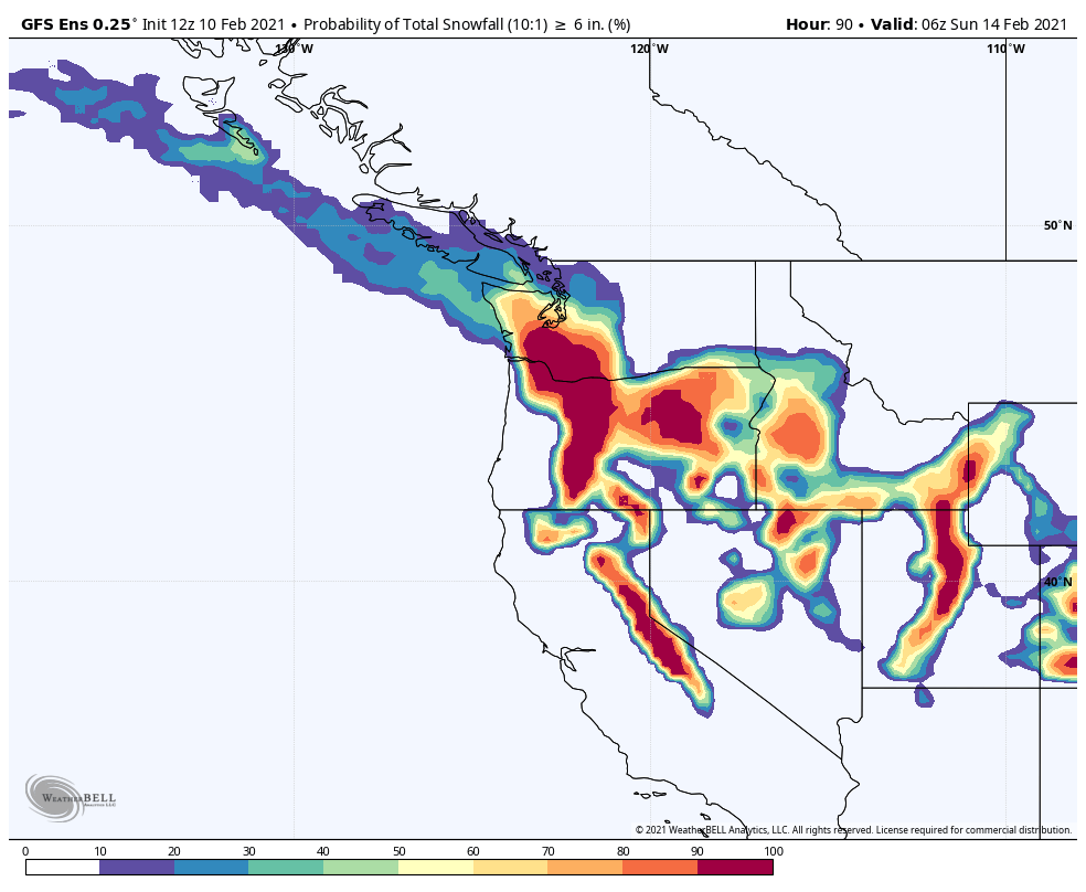
Locations north of Seattle along the northern edge of the heavier snow bands have the greatest uncertainty in snowfall totals. The models are unlikely to resolve that uncertainty before the storm hits and we will have to ‘nowcast’ in real time to know more.
Will this storm make history?
The threshold for a record-breaking snowfall is quite high thanks to a number of big snow events from the 1950s-1970s. The all-time snowfall record appears safe. However, it has been nearly 50 years since Sea-Tac airport recorded more than 8″ of snow in a day, which is possible if the heavier snow holds off until Saturday morning. A 9.8″+ snowfall in two days (Fri-Sat) to make the top-10 list is possible, especially since Sea-Tac airport is south of downtown Seattle where the snow totals will be a bit higher.
Note that Sea-Tac did not report snowfall observations from the mid 1990s-early 2000s, so one big storm from December 1996 is missing in the official records.
What could go wrong?
Disappointment is a big part of snowstorm forecasts in Seattle, and there are a couple of potential ‘bust’ scenarios for this one. Although, as noted above, even in the worst case scenario it appears that 4-6″ of snow is likely by Saturday evening.
1. Storm #1 misses Seattle to the south
The GFS has been consistently farther south than other models with the first storm on Thursday into Friday. While a couple inches less of snow will not matter much in the big picture, it would still reduce the odds of the final storm total ending up in the historic 12″+ range.
2. Dry air/downsloping from the Cascades
The GFS has consistently shown a stronger intrusion of dry, arctic air than other models (which is associated with the more southerly track of storm #1). Midday Friday the GFS is showing 25-30% relative humidity in the Seattle area. The European model has 60-70% relative humidity at the same time.

If the air is too dry, it will take time to moisten up, although areas south of Seattle and the Kitsap Peninsula would be less affected.
3. The snow changes over to sleet or rain on Saturday.
All of the models have moderate to heavy snow in the Seattle by Friday evening. But with the heavier precipitation comes warmer air from the south. The ECMWF does show some sleet/freezing rain mixing in with the snow by Saturday morning to the south of Seattle, especially in the foothills where downsloping will add a bit of warming.

For now it looks like the Seattle-Tacoma-Olympia area will stay all snow until the majority of the precipitation has cleared. But if the low pressure system comes in a bit farther north than expected there could be more issues.
Final thoughts
This storm has a good chance of being the top weather event of 2021 in the Seattle area. The heavy snowfall rates on Friday evening into Saturday are rare in the lowlands west of the Cascades and amazing to experience in person. I encourage snow fans to get preparations done today and tomorrow morning and try not to worry about the forecasts, which will surely evolve a bit as we approach Friday. Even 6″ of snow is a big storm, so don’t get too disappointed if we miss out on a foot of snow.
And most importantly–make sure to thank our professional meteorologists, who have a long couple of days ahead of them and a very difficult forecast to make.

What are the chances that Sunday will be included in this storm? I’m supposed to be driving from Seattle to Tri-Cities on Sunday morning.
LikeLike