

Time to stock up on bananas and hunker down, the snowiest period since February 2019 is headed for the Pacific Northwest. While there is still some uncertainty about specifics, there is high confidence that the western WA lowlands, particularly the Seattle-Tacoma-Olympia corridor, will experience a period of snowfall at the end of the week.
In fact, there are three potential snowy periods between Wednesday afternoon and Sunday morning. So even if one system doesn’t work out there is still the potential for a couple inches of measurable snow over a large area.
Quick summary
- Lowland snow is possible in western Washington and northwest Oregon beginning late Wednesday and continuing through Sunday.
- Several inches of snow ( at least 2-4″) are likely across much of the region.
- More significant snowfall totals (6-12″) remain a possibility.
- There is a threat of freezing rain in the Portland and Columbia Gorge area on Saturday.
The big picture
Lowland snow in the coastal PNW requires a delicate balance between cold, Arctic air and moisture from storm systems approaching from the Pacific. The setup on Thursday evening shows how the storm will come together.
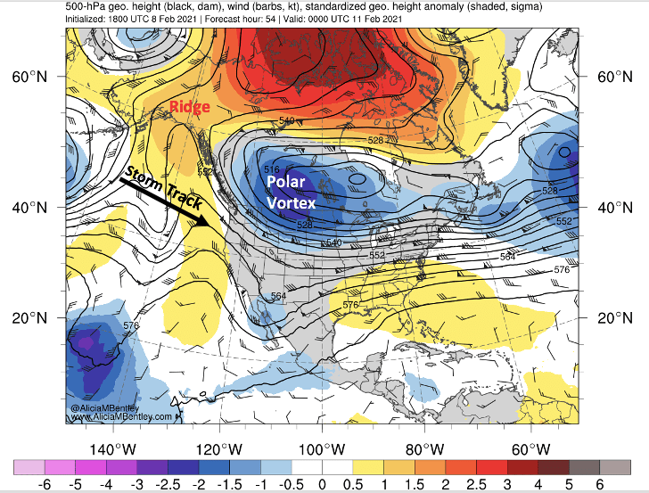
There is no shortage of cold air available from a piece of the polar vortex to our northeast. The ridge over the NE Pacific is another common feature of snow events in the PNW–however, this ridge is weaker we would usually expect, which will allow a pair of low pressure systems to track underneath the ridge, approaching the coast from the west-northwest.
The more southerly track of the low pressure system (rather than tracking over the ridge and dropping down from the NNW) allows both storms to tap into a subtropical moisture source. Two corridors of elevated precipitable water can be seen in the EMMWF forecast below, which will provide plenty of moisture for snow.

Often this storm track would be a recipe for rain, but thanks to the strength and extent of the Arctic air mass, it should remain cold enough for snow through the end of the weekend. In fact, if you believe the American GFS model, there will be too much cold/dry Arctic air, keeping most of the snow to the south of Washington State. Past experience suggests that the GFS model overdoes cold air intrusions, so I will focus on the ECMWF forecasts which appear to be more realistic.
Wednesday-Thursday morning — snowflakes along an Arctic front
The first opportunity for widespread snowflakes is on Wednesday into Thursday, as cold air pouring through the Fraser gap will generate a bit of frontal lift.
Arctic fronts are always tricky to predict so it’s hard to estimate snowfall from this setup. Historically, the Port Angeles/Sequim area usually gets the most snow from this setup with a brief burst of snow possible elsewhere.
However, as Anthony Edwards astutely noted in his thread, southerly winds will increase ahead of Thursday’s approaching low pressure system. So there is the potential for the front to stall over the region. The ECMWF deterministic run appears to show this scenario, with snow continuing into Thursday across the southern half of Puget Sound.

Thursday-Friday — low pressure system #1
After the initial snowfall on Wednesday, which is likely to be spotty in nature, a low pressure system will bring a swath of accumulating snow starting Thursday morning.
This first low pressure system can be seen approaching in the above forecast from the ECMWF. By Thursday evening, the low center is expected to be offshore of Oregon.

As you can see, there is still some spread in the ECMWF ensemble members. A track closer to the WA-OR border would be more favorable for snow in the Seattle area while a more southerly track would favor the Portland area.
Ensemble mean snowfall is in the 2-4″ range from this system, with the best chance between Portland and Seattle in the I-5 corridor. Lighter amounts are possible in eastern Washington.
Saturday — low pressure system #2
A second low pressure system will move in right on the heels of the first one. Since this storm is farther in the future there is a little more uncertainty. However, most of the Euro ensemble members have a low pressure system somewhere off the coast of Washington state on Saturday.

This storm has a lot of moisture associated with it and has the potential to bring snowfall to a larger area that the first storm.

The above image is just one model snapshot of the storm, from the latest 12 UTC ECMWF deterministic run, but the extent of the snowfall band is impressive. The model also hints at an added forecast challenge–warm air overrunning may bring freezing rain (pink color) to the Willamette Valley and Columbia Gorge in Oregon, as well as the Portland metro area.
Because the precipitation is expected to be widespread, there is some room for error in the track and higher confidence for snow than we would usually have with such a large model spread in the low pressure positions. It appears that a broad area will see at least a couple inches of snow from this storm and potentially more.
Adding it all up
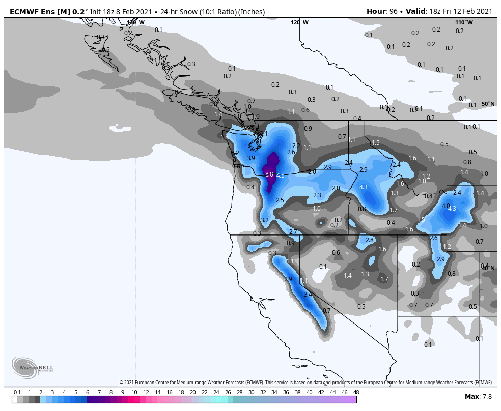
With so many different scenarios, it is challenging to predict specific numbers. But we can take a look at the ECMWF ensemble snowfall totals to make an estimate.
For Seattle (Sea-Tac), the latest ECMWF ensemble mean shows 8″ of snow (at a 10:1 ratio) by Sunday.

However, there is considerable variability in the ensemble members. Around 80% of members have at least 3″ of snow, 60% have at least 6 inches, and a couple outliers have over a foot of snow.
Given the cold temperatures, the snow:liquid ratio is likely to be greater than 10:1 for much of the snowfall. So I’m quite confident that Seattle will see at least 4-6″ of snow by Sunday and potentially more. The cold temperatures will also allow snow to accumulate on road surfaces and cause significant travel impacts.
In Portland (KPDX), lesser amounts are predicted by the ECMWF ensemble, with a greater likelihood of the snow mixing with rain or changing entirely to rain by Saturday. That said, a few outliers show a scenario where more southerly low tracks would result in more significant accumulations in Portland.

To the north, the ECMWF ensemble is also predicting a little less snow in Bellingham than Seattle, as the cold, dry Fraser outflow will reduce the amount of snow on the northern extent of the system. However, there are still a number of ensemble members in the 8-12″+ range, and the snow:liquid ratio should be even greater in Bellingham than Seattle, potentially 15:1 or more at times.

Will it be an ‘epic snowpocalypse’?
Probably not, but it isn’t outside of the realm of possibilities. The ECMWF ensemble shows a 10-20% probability of more than a foot of snow in the Seattle area, with slightly higher odds in the Olympia/Centralia area.

Getting a foot of snow would require a direct hit from both of the low pressure centers, in addition to some help from 15:1 snow:liquid ratios. Can’t rule it out quite yet…
What if the ‘no snow’ GFS model is right?
We’ll all be making banana bread with our extra bananas while enjoying some chilly sunshine this weekend.

I love your blog posts — so informative. One correction I would suggest though:
Seattleites, historically, stock up on bread, not bananas! So buy your bread now before the shelves are empty!😂
LikeLike