

The parade of cold season frontal cyclones ended several months ago, but one last reminder of winter will greet the PNW on Thursday morning.
A loop of precipitable water posted by the NWS shows the cyclonic (counter-clockwise) rotation of a low pressure system off the coast of British Columbia on Wednesday morning with a ribbon of moisture extending back to the subtropics.
The model forecast integrated vapor transport (IVT) shows a cold front and associated atmospheric river making landfall on early Thursday morning. The flow has a south-southwest orientation so the Olympic Mountains rain shadow will set up to the north of the Seattle metropolis.
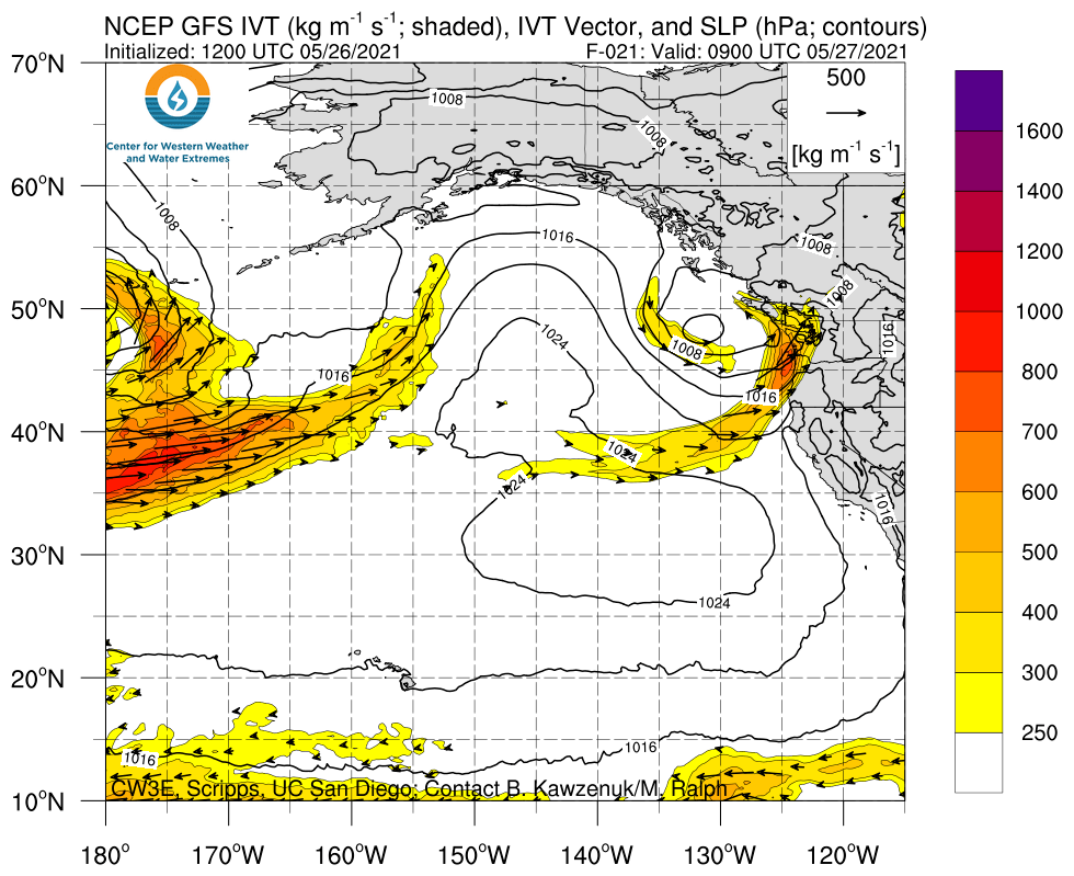
The IVT values are in the “moderate” range (500-750 kg/m/s) which is northing exceptional in the stormy season for this part of the world. In November we would barely notice this storm, but in late May it will bring a welcome soaking ahead of an upcoming warm/dry spell. Since the front will pass through quickly, rainfall totals will generally be in the quarter to half inch range in the lowlands with more in the mountains.
Thunderstorms Thursday afternoon?
Behind the front, skies will partially clear by late Thursday morning. Given the favorable timing, there is an opportunity for the atmosphere to destabilize thanks to the high sun angle and relatively colder air moving in aloft behind the front. The UW-WRF shows an upper-level trough swinging through on Thursday afternoon with chilly 500 hPa below -20 C.

The 4/3 km WRF simulated radar reflectivity shows an active afternoon and early evening with several periods of showers and thunderstorms. The image below is just one screen capture showing widespread activity by 1 PM Thursday. The storms are likely to consolidate into a convergence zone in Snohomish County by late evening.

I like seeing the axis of the trough (along with the coldest air at upper levels) passing through at the time of peak daytime heating (afternoon-evening). Hopefully that will favor some impressive convective development.
Mountain snow
It’s not too late for a little mountain snow–with cold air aloft the snow levels will fall to 5,000 ft or so. Keep an eye on the webcams at Crystal Mountain and Paradise on Mt. Rainier on Thursday afternoon.

The marine layer gets “sucked” out of Puget Sound
One interesting effect of the approaching storm was an increase in southerly flow on Wednesday morning across Puget Sound as a result of the increasing south-north pressure gradient.
I recommend watching this loop a couple dozen times and focusing your eyes on different parts of the image. You can see the low-level clouds eroding on the eastern side of the Cascades, gap flows through the Cascade passes, flow deflection around the southern side of the Olympic Mountains, and wind shear as the high level clouds approach directly from the west.
Most of these effects occur on a daily to weekly basis, but it is rare for the clouds to act as such perfect flow tracers.
The almost magical “sucking” of the marine clouds out of Puget Sound also brought an end to a “May gloom” period of 9 straight days of mostly cloudy skies and below-normal high temperatures.

A warming trend for Memorial Day weekend
The cold air behind Thursday’s front will not stick around. Instead, a ridge will build along the Pacific coast just in time for Memorial Day weekend and the beginning of meteorological summer (June 1).

Lowland temperatures should reach the upper-70s to low-80s by Memorial Day!
