

The upcoming weekend and early next week promise to bring another period of active weather to the Pacific Northwest. The culprit is a broad trough of low pressure that will deepen and park itself off the west coast as we move into the weekend.
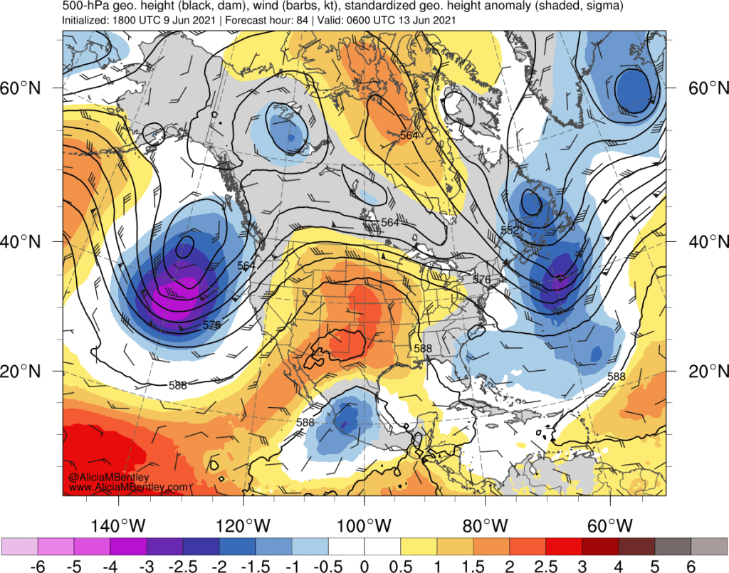
This trough is deeper than the one that brought clouds and rain to the PNW last weekend and is associated with an unusually strong jet stream for late June. But what is really impressive about this upcoming series of storms is how much moisture they are expected to pull in from the subtropics.
Here’s the forecast precipitable water (i.e. total water vapor content of the atmosphere) for Saturday evening, the same timestamp as the image above.
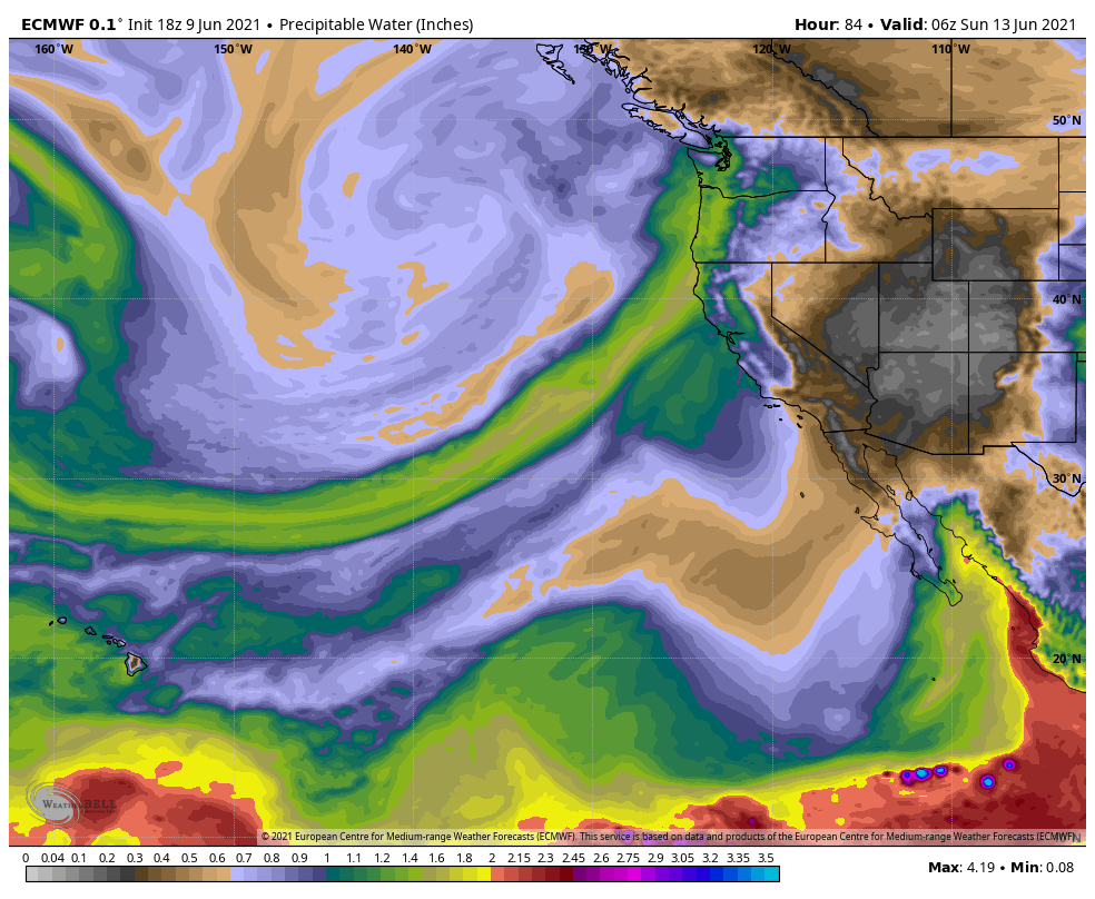
This is a classic atmospheric river setup that we often see in winter, with added warmth and moisture thanks to the calendar reading June instead of November.
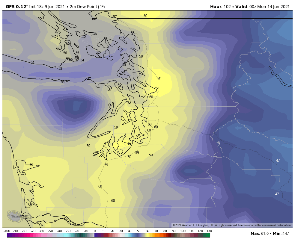
The forecast dew points are unusually high for this part of the world, particularly on Sunday afternoon and evening as the strongest of the disturbances pushes through. The GFS is predicting surface dew points around 60 across the western WA lowlands.
The ECMWF is more extreme, with forecast dew points reaching 65 around 8 PM Sunday evening.
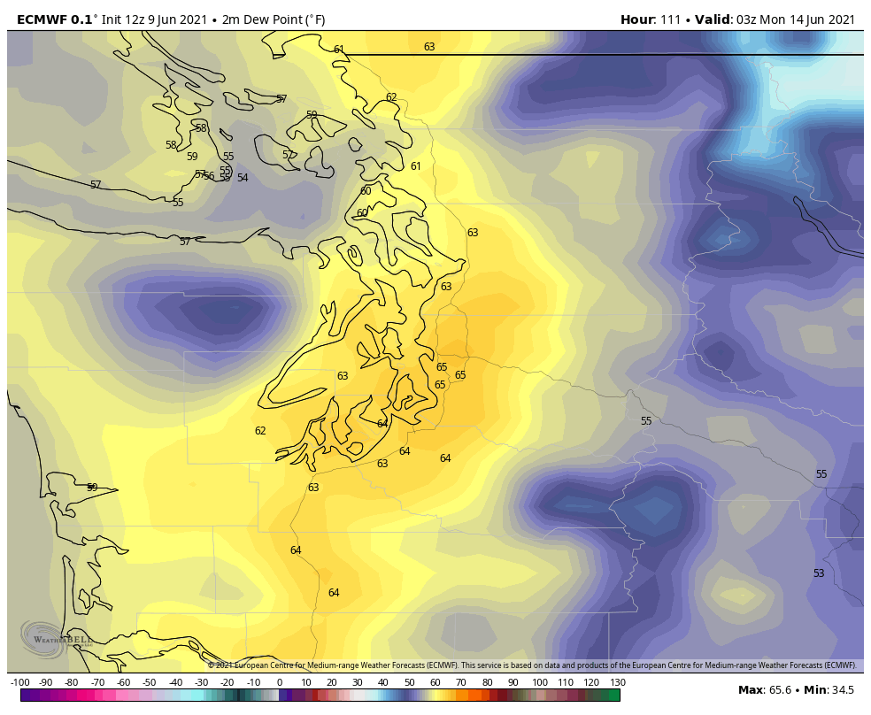
A dew point of 65 is pushing record territory in this part of the world (see below), so I tend to be a bit skeptical of this ECMWF run. Plus, weather models are notoriously bad at predicting surface dew point. So we need to look at this forecast in the context of historical events to determine if mid-60s dew points are really possible on Sunday.
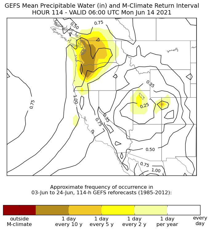
Moisture approaches once-in-a-decade levels
Whenever extreme weather is predicted I often turn to the amazing ensemble situational awareness tool produced by the NWS. The tool works by comparing the GFS ensemble forecast to an archive of past forecasts for the two weeks on either side of the forecast date. The precipitable water forecast for Sunday evening is near or at the maximum in the ~ 20 year dataset.
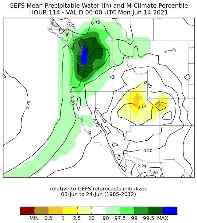
It’s a little bit easier to think of this event in terms of a “return interval” which is estimated to be one day in every 10 years for this level of forecast precipitable water in June.
Dew point climatology at Sea-Tac airport
If we accept that atmospheric moisture on Sunday will be near a 10-year max for June, what dew point might that translate to? To answer this question I downloaded all of the hourly dew point data at Sea-Tac airport going back to 2007. The resulting plot shows the 14-day rolling average and daily maximum dew points for KSEA.
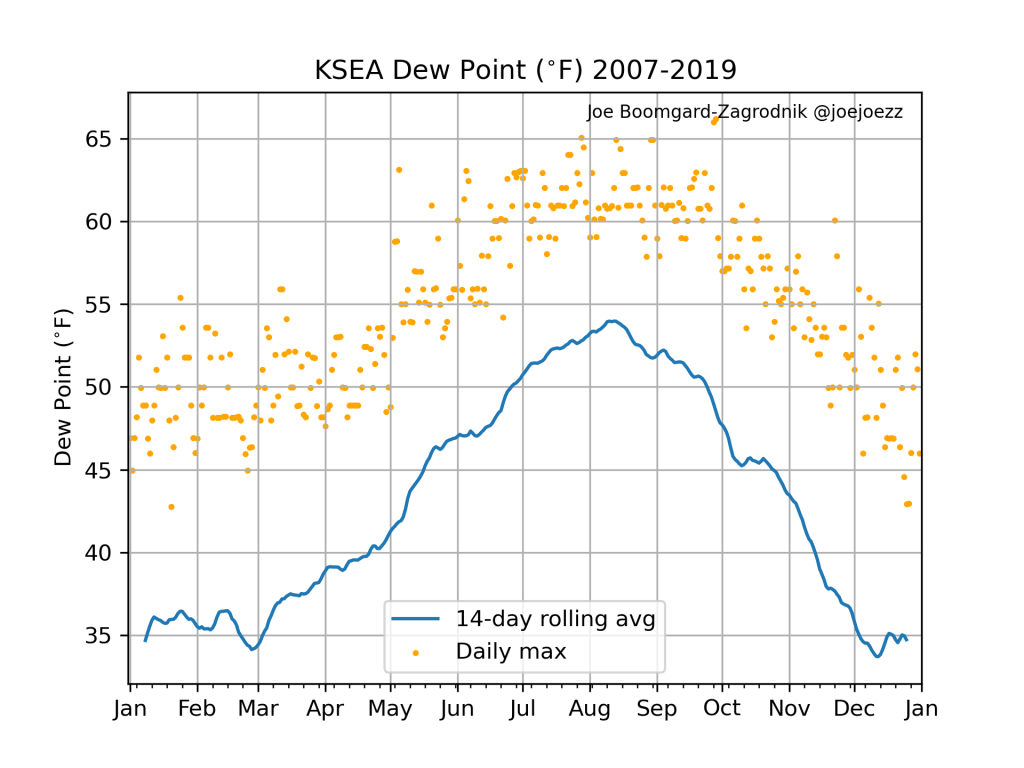
Interestingly, the record max dew point over this period was 66 F on September 27-28, 2010. June has seen a few instances the dew point reaching 63 F, most recently in 2016.
It could be worse
Despite its rainy winters, Seattle isn’t known for oppressive humidity. The relatively cool sea surface temperatures of the northeast Pacific tend to keep moisture levels lower than most of the continental US east of the Rockies. As a result, the populace has a low tolerance for muggy weather. When I googled “dew point comfort scale” it returned this approximate chart from WSEE out of Erie, Pennsylvania:
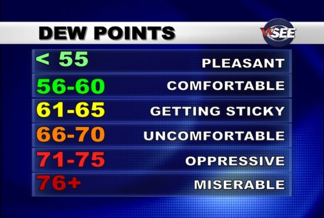
In the PNW, complaints of uncomfortable humidity tend to start when the dew point reaches the upper-50s. The dew point in Seattle reaches the 61-65 “getting sticky” category for just 39 hours per year on average. And the top 3 categories in the above chart have never been reached in Seattle (since 2007), except for the 3 hours it reached 66 F in September 2010.
In comparison, the AVERAGE hourly dew point in Miami, FL is 67 F, for the entire year. So if Sunday feels humid to you in the PNW, I recommend never moving to Florida, or anywhere in the Southeast US for that matter.
What about the rainfall forecast for this weekend?
With a moist airmass in place and some forcing from the trough offshore, a rainy weekend is on the way. Fortunately, the rainfall will be showery in nature so there will be plenty of dry periods.
Through Tuesday afternoon the deterministic ECMWF shows around an inch of precipitation in the western WA/OR lowlands with up to 2 inches in the mountains. Impressive numbers for mid-June.
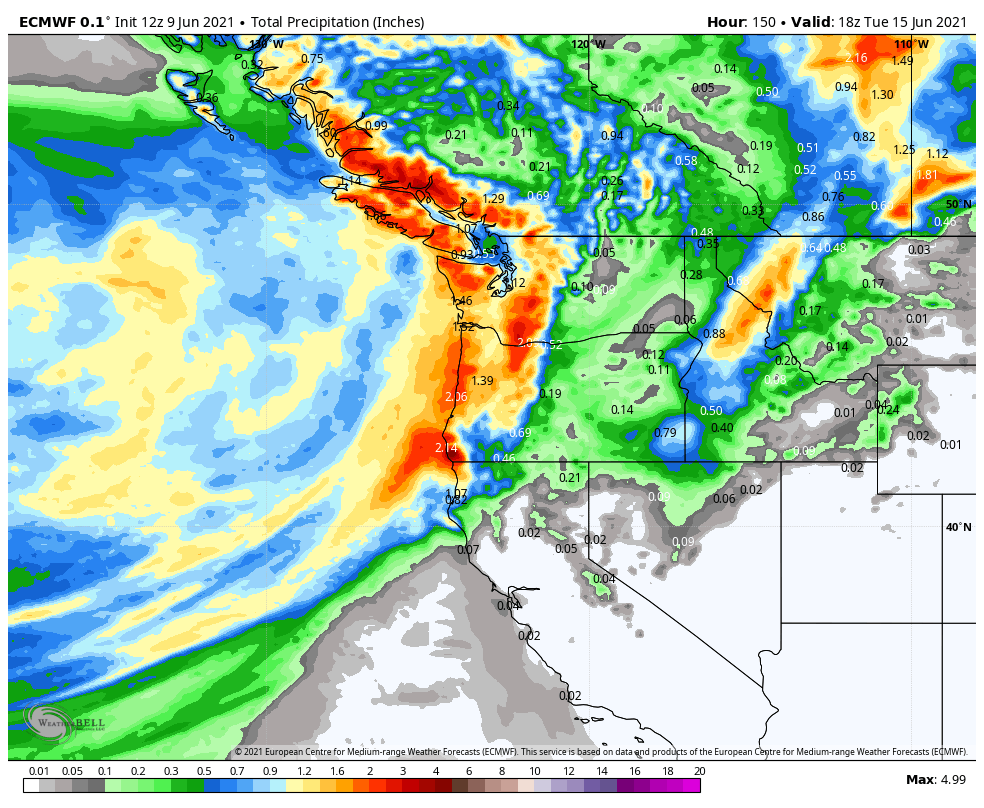
Unfortunately it doesn’t look like much rainfall will reach California or eastern WA/OR where drought has become a major concern.
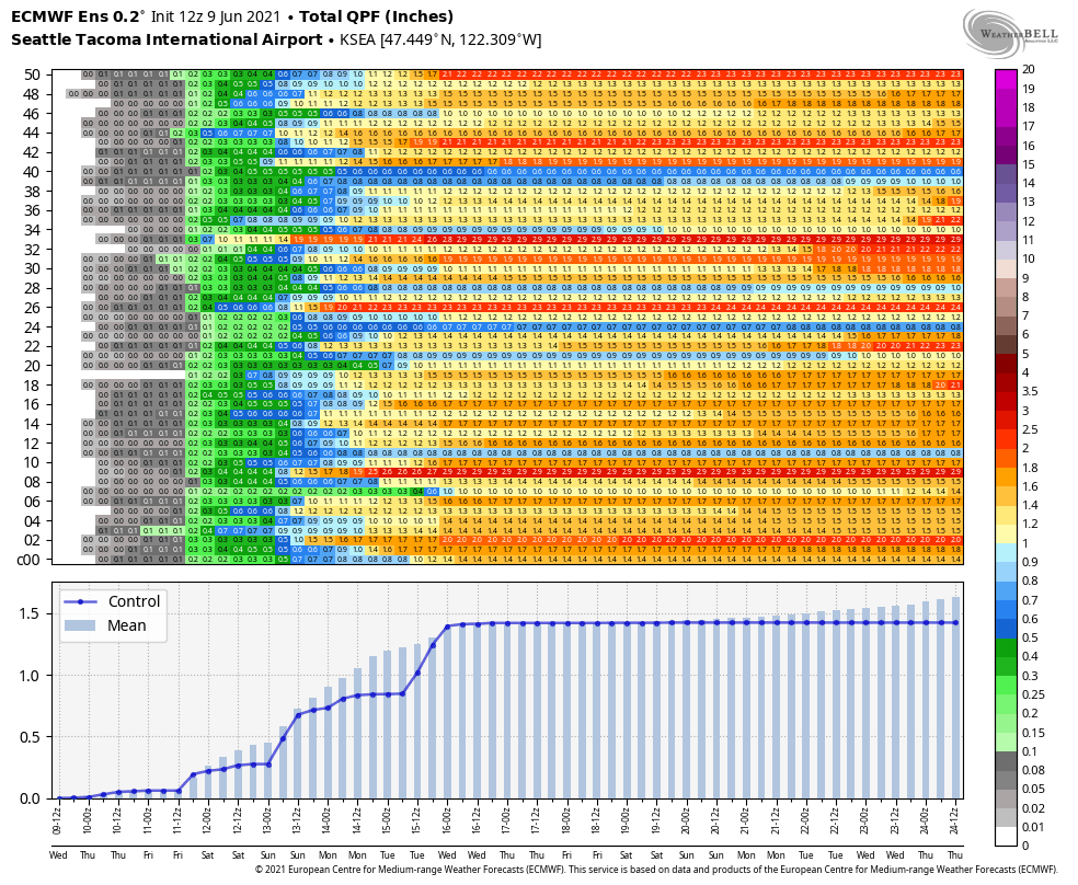
The ECMWF ensemble for KSEA shows high confidence in >1 inch totals by early next week.
As for thunderstorms, temperatures aloft look to be quite warm through Monday so I do not expect much thunder/lightning. When the trough finally moves inland next Tuesday there might be a better chance for some storms.

I like the looks of this picture you’ve drawn, especially the aside where you say there’ll be sunshine between the clouds… I wish the local weather mavens (Seattle Times, Weather app on iPhone) would acknowledge this reality, and tell us in is not gray and wet for the day in their graphics, and show % blue! Thanks for your good work…
LikeLike