

As has been widely reported, a potent cold snap is descending on the PNW. As of this writing on Friday afternoon (Christmas Eve), cold, arctic air is already beginning to move into Whatcom County through the Fraser Valley. By Christmas (Saturday) evening into Sunday the cold air will spill across much of western Washington and eventually the entire PNW.
The 850 hPa temperature anomaly plot for Sunday shows the anomalously cold airmass sandwiched between three areas of anomalously warm air. A cold Christmas is more of the exception than the rule in North America this year.

Many of us in western Washington are curious to know more details about the timing of various weather events this weekend and early next week, so we’ll run through some of the details in this post.
Friday evening – Saturday (Christmas Day)
Radar imagery on Friday afternoon shows a well-defined low pressure center spinning off the coast of the Olympic Peninsula.
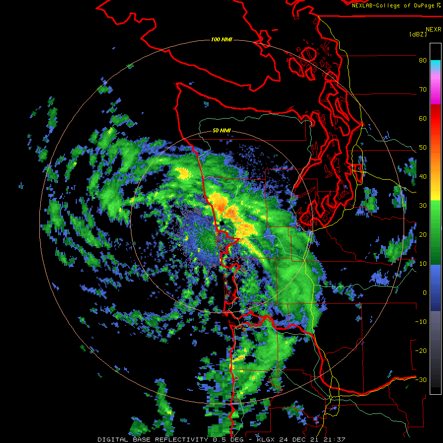
This low pressure area is not only helping to pull cold air into western Washington, but it is also generating precipitation that will increasingly be in the form of snow as the low makes landfall Friday night.
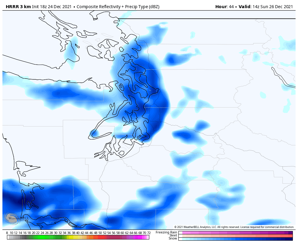
By Saturday morning (7 AM), the high-resolution HRRR model shows widespread snowfall across much of western Washington. However, the central Sound including Seattle will likely be “shadowed” by the Olympic Peninsula as a result of westerly winds at mid-levels.

24-hour snowfall totals from 4 PM Friday – 4 PM Saturday (via the ECMWF model) appear to be in the 2-4 inch range in most areas. The exception is the “snow shadowed” areas such as Seattle and the Kitsap Peninsula.
Temperatures at 4 PM on Saturday are expected to be above freezing in the lowlands, so some of the snow is likely to melt. Whatcom County will be a different story with temperatures in the 20s and strong winds. Travel will be difficult.
Saturday night – Sunday
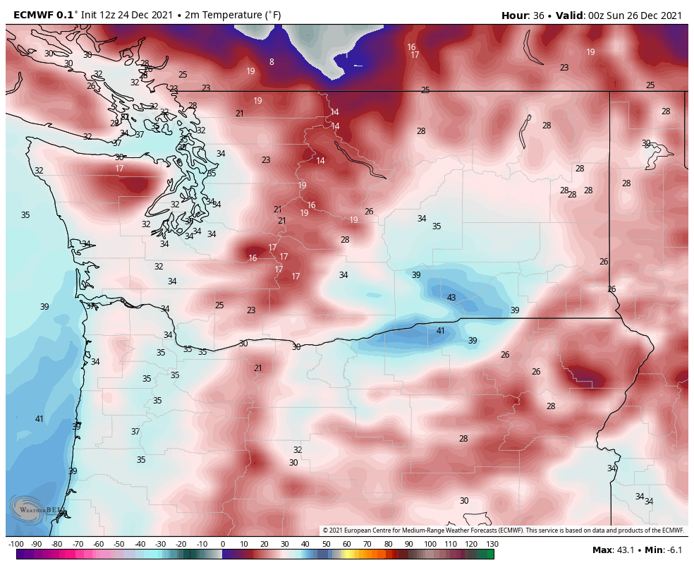
Colder temperatures will push farther south on Saturday night. By Sunday morning it will look and feel like winter across most of the PNW. At 10 AM Sunday, temperatures will be in the teens in Whatcom County and the upper-20s across the rest of western Washington.
Additionally, a band of snowfall is expected to develop across the central Sound on Sunday morning, which will be the best opportunity for accumulating snow in the Seattle area.
The HRRR shows fairly widespread snow on early Sunday morning with the band of snow generally moving in a north to south direction.
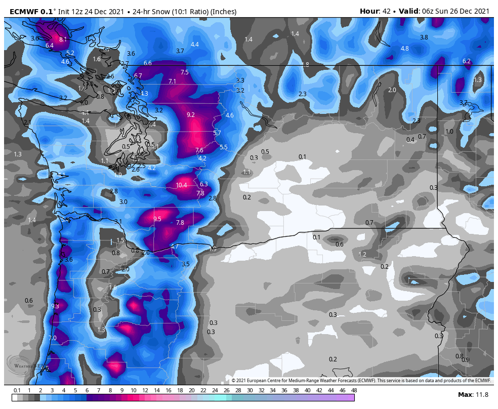
The ECMWF has been showing impressive snowfall totals of 3-6 inches over the 24 hour period ending 10 PM Sunday night.
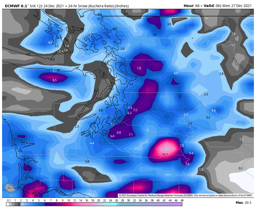
The GFS is in the 1-3 inch range in the central Sound.

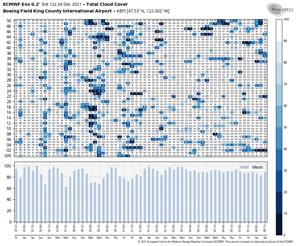
Ensembles are in fairly good agreement on this snow band forming. The ECMWF ensembles are mostly in the 3-5 inch range at Sea-Tac for the 24 hour period shown above. For Boeing Field (not pictured), the amounts are a little lower, 2-4 inches.

Given the banded nature of the snowfall, amounts will likely be highly variable with the greatest accumulation on hills and away from the water. The high-res maps have been showing that places known for missing out on snow such as the Ballard neighborhood and downtown Seattle will be on the lower end of the above ranges. The foothills will likely exceed the above ranges, potentially up to 8+ inches in spots
How cold will it get next week?
Models have backed off the more extreme temperature forecasts, but it will still be one of the coldest periods in the last several decades. The ensemble mean 850 hPa temperature (~5000 ft above sea level) is expected to bottom out around -11°C at Quillayute on Sunday night/Monday morning.

At one point some of the deterministic models were below -15°C, near all-time records, but -11°C is still cold enough to approach daily record minimums.
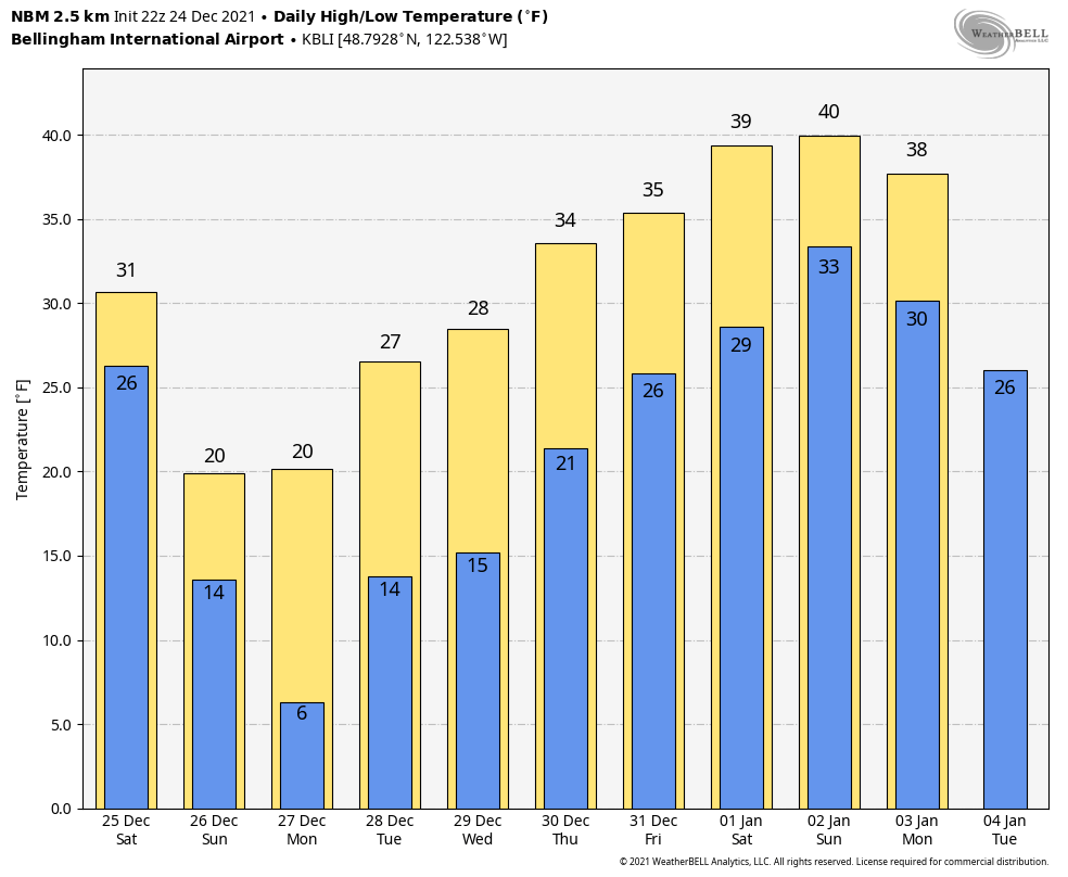
With fresh snow on the ground, Monday morning is likely to be the coldest of the period. The NOAA NBM statistical model shows a low of 17°F and a high of only 25°F for Sea-Tac on Monday. That would be the coldest at Sea-Tac since a low of 14°F in November 2010.
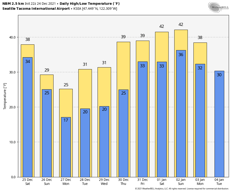
While it is likely to be cloudy on Sunday night, a few of the ECMWF ensemble members do show some clearing. So if there is a decent snowpack at the airport and clearing at night, there remains a possibility of reaching that 14°F number. The record low at Sea-Tac is 20°F on Monday. The last time Sea-Tac set a record low in Decemeber was 2013.
The NBM forecast for Bellingham airport is more impressive — a low of 6 °F on Monday morning.
When will the cold end?
As the NBM forecasts show above, temperatures are likely to warm by the start of 2022. However, models tend to be too aggressive in clearing out cold air and additional snow will be possible.
Furthermore, some models are showing a second shot of cold air during the first week of January. So the snow chances might continue for a while…

I think your forecasts are very interesting and informative. Unfortunately, I live in Spokane! Do you know if anyone is doing what you are doing for eastern Washington?
LikeLike
I’ll try to add more information about Eastern WA going forward! I was more in tune with the weather there when I was working at WSU.
LikeLike
Joe, your thoughtful and accurate forecasts are a delight to read & ponder. Another local & popular forecaster (via radio?) takes a more bombastic approach, with an unfortunate effect on the parents of our grandchildren. They’re frequently & unnecessarily all spun up. Sigh.
I’ll try to steer them your way.
LikeLike
Thanks Dennis!
LikeLike
At least as far as Bellingham is concerned, I think the NWS did a very good job in predicting the change in pattern and the resulting strong and cold Fraser River outflow. I think they have missed a bit on how cold it was going to get. It got down to 7F at our place, which is a few degrees colder than predicted. It is the coldest temperature we have had in the 6 years we have been in Bellingham. 7F is still is above the all-time low of -2F, but nonetheless was a record for the date. NWS was a bit low on the snow forecast for Saturday and Sunday. I estimated we got about 5-7″ of snow. They were also low on last night’s lighter snowfall, which I estimated at 2″. As Joe indicates and as my 70+ years of living in the Northwest confirms, the timing of the end of these patterns can be very hard to predict and typically they last longer than the ongoing forecasts project. It is a great illustration of “persistence” in the weather. The big worry connected with the transition out of this pattern is a period of freezing rain, which can cause a fair amount of damage and disruption. It seems we always hope for a vigorous storm out of the south to scour out the cold air and warm up the surfaces before the rain starts. But after a very long and intense cold spell, this frequently does not occur. One this finally departs, this weather will likely move the middle of the country.
For what it is worth, many weather stations in Alaska, including some in the interior, have been warmer than Whatcom County.
LikeLike
Yes, the Alaska ridge was more anomalous than the PNW trough for sure!
LikeLike
We had about 8″ to 10″ of light, fluffy snow last night. It was more than forecast, but certainly within the normal margin of error. We were well-prepared by NWS. Even though the northerly winds are persisting, it is currently at 28F at noon. Current forecast is for New Year’s Day to be the transition.
LikeLike
The transition was only a bit delayed here, but the weather gods blessed us with warming winds without freezing rain. There has been no precip since the transition started. Although NWS has a high wind warning continuing up to 4 am Monday morning, the forecasted wind strength is not highly unusual for this time of the year. Winds appear to have possibly peaked an hour or two ago in the low 50’s at the airport, but perhaps they will strengthen again. The barometer has not bottomed out yet. The PSE outage map only has a small number of outages in the Bellingham area at this time.
LikeLike