

The first half of December has brought chilly weather to the Seattle area, but temperatures have remained above freezing with a few close calls for snowflakes resulting in all rain.
Over the last week, the promise of colder weather and a white Christmas has been hinted at in the extended forecast, with considerable uncertainty. In the last day or two, the weather models have come into better agreement that a period of arctic air will move into the PNW around Christmas, with at least some snowflakes likely to fly. Let’s take a look at the latest projections.
Large scale pattern
The large scale pattern is about as good as it gets for cold weather in the PNW. The 5-day 500 hPa anomaly forecast below (Dec 24-29) shows a classic “Alaska block” pattern which tends to allow weather systems to approach the PNW straight from the north following the BC coast (parallel to the height contours on the map).

Any weather system that does approach during this time period will have a reservoir of anomalously cold air to tap into in western Canada.

A rough rule of thumb for Seattle is that snow is likely when the 850 hPa temperature is -6 °C or lower. By that threshold, snow will be possible in the Seattle area from roughly Christmas day through New Year’s day.
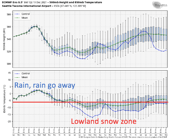
The best way to interpret the above map is to use the green line (ensemble mean), which represents the most likely forecast. The deterministic run, in blue, is too far outside the ensembles to be considered a realistic possibility.
Based on the ensemble mean, the forecast is not really that close to the -6°C threshold. The green line appears to dip down in the -8 to -9 °C range. So there is the potential for temperatures to be comfortably below freezing.
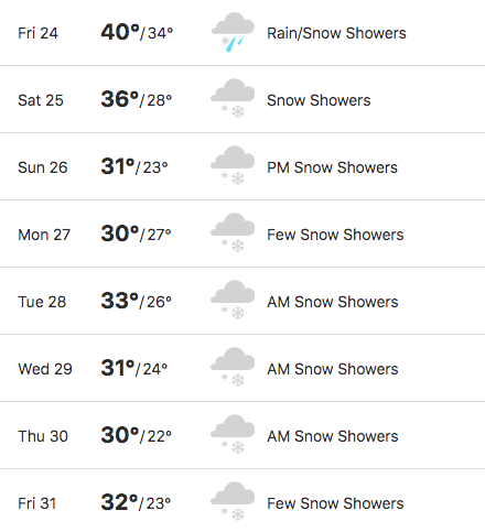
I wouldn’t be surprised to see Seattle reaching down into the low 20s°F at night if the current projections are correct, with teens in outlying areas and north of the city. The latest forecast from IBM/The Weather Channel, which is known to be one of the best out there, gives a rough idea of the likely temperatures in Seattle proper over this period.
Will there be any moisture?
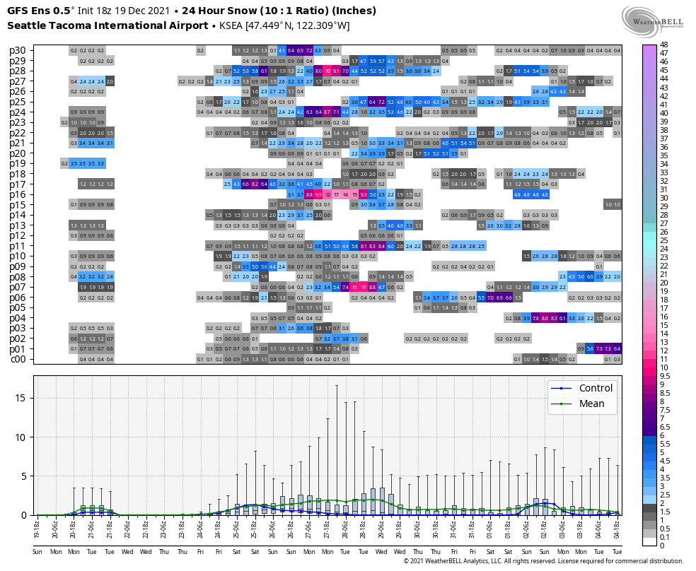
The short answer is yes, but the details are challenging to sort out. Here’s the latest ECMWF ensemble 24-hour snowfall accumulation forecast for Sea-Tac. I find this map, which shows snowfall over the previous 24 hours at each time step, to be a useful way to gauge forecast uncertainty.

After a slight chance of a dusting of snow on Monday morning 12/20 (likely rain at sea level), the more serious snow chances begin from the 24th-25th and continue through the 29th-30th. However, the ensemble members all have the snow starting and ending at different times, so it’s next-to-impossible to figure out where and when it’s going to snow.
The good news for snow lovers is that almost every ensemble member has at least some snow in the Dec 24th-29th time period, so we can say with fairly high confidence that Seattle will see at least some snow prior to the new year.
It’s also worth noting that there does not appear to be a strong signal for a major snow event (6-8″+), although a few ensemble members do hint at decent snowfall totals.
The GFS ensembles paint a similar picture of uncertainty.
Why the uncertainty? Unlike our rain systems, which tend to bring widespread precipitation, the dry arctic airmass results in smaller and less organized areas of precipitation. And these storm systems tend to be more sensitive to small changes in the track of the low pressure system.
At least as of today, December 19, it looks like the first primary snow threat will be with the initial surge of arctic air on Christmas Eve – Christmas, followed by a second threat on the 27th-28th as a low pressure system drops in from the northwest. Additional snowfall may fall beyond the 28th, but it is too far in the future to speculate at this time.
One way to gauge uncertainty is by examining the ensemble probability of snowfall exceeding 6 inches by the evening of December 30. Currently the ECMWF shows a 50% of 6+ inches of snow in Seattle, with higher chances to the north of the city.

The odds of 3+ inches of snow (not pictured) are around 90%. Numbers look similar for the GFS.
So, it’s a bit of a waiting game now until the models come into better agreement about snowfall. In the meantime, the region can begin preparing for what may end up being the coldest week of the winter (although we still have 2+ months to go…).

One comment