

Weather models have been hinting at a lowland snow event for the last few days and we finally have some clarity on what is likely to happen on Monday morning. The short answer is that it’s about 50/50 right now for seeing snowflakes in Seattle proper, with minimal accumulation expected.
Models continue to show a brief period of light snow across much of the Puget Sound region late Sunday night into early Monday morning. If snow does occur, it does not look like a major travel disruptor, but it does bring the possibility of a dusting up to maybe an half-inch of snow before turning to rain by late morning.
Before going into the details, the main takeaway point is that we’re looking at a marginal event with the temperatures just barely cold enough for snow. The fortuitous timing of the storm’s arrival around the coldest time of day in the early morning hours is the main reason have hope of avoiding a 37 or 38°F rain event. Although the cold rain scenario does remain a possibility if the storm comes in a few hours later or just a tad warmer than current prediction.
The setup
At first glance, the setup for this event is not especially impressive. The 500 hPa heights and anomalies below shows that the main core of cold air will be in the upper Midwest. However, a few other features that often lead to lowland snow will be present. A ridge will be present in the Gulf of Alaska and a weak disturbance (marked by the red arrow) will slide southward along the downstream side of the ridge.

Temperatures in the lower atmosphere (850 hPa) will be slightly below normal. A large reservoir of warm air will be present just offshore. Some of that warmer air will advect into western Washington by Monday afternoon.
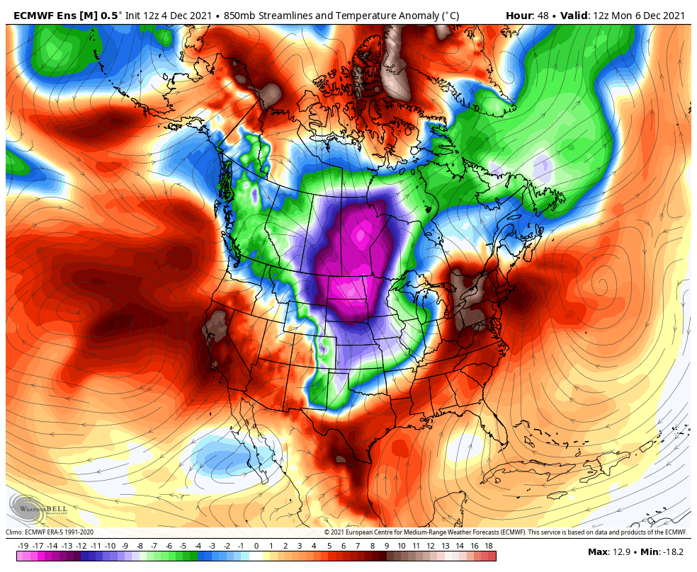
In absolute values, the 850 hPa temperature will be around -6 °C on Sunday evening, rising to somewhere in the -4 to -5 °C range by Monday morning and over 0°C by Monday afternoon. It’s very hard to get snow at sea level with the 850 hPa temperature above -5 °C in this part of the world, so this is going to be very, very close.
The other piece of the puzzle is a surface area of low pressure which is expected to be located somewhere off the coast of Vancouver Island on Monday morning. The track of surface lows tends to be key to getting snow around here. A few days ago, some of the models (e.g. the GFS) had the surface low making a near-ideal landfall near Astoria, OR. More recently, the models have show a weaker low (or even just a broader trough of low pressure) that dissipates offshore without ever making landfall.
The latest deterministic GFS shows that scenario, but it still shows some precipitation ahead of the low along a warm front, with temperatures cold enough for snow. The image below shows precipitation in the 1 AM – 4 AM time period on Monday morning.

The ECMWF has continually shown a weaker surface low with a more northerly track. That continues to be the case in the latest run. In fact, this run is showing almost no lowland snow in western WA.

The high-resolution HRRR model is probably the most optimistic for snow in the Seattle area, with a nice band of snow over Seattle around Sunrise on Monday morning.

What do the ensembles say?
Ensemble forecasts have been incredibly valuable in the lead up to this event. Ensembles are basically the same model run many times with slightly perturbed initial conditions or physics. The spread in ensemble forecasts gives us an idea of uncertainty. An example of why this is useful was seen a few days ago the deterministic GFS was showing several inches of snow for the Seattle area. Only a handful of ensembles supported the heavier snow scenario, so it was never viewed as a serious possibility by meteorologists.
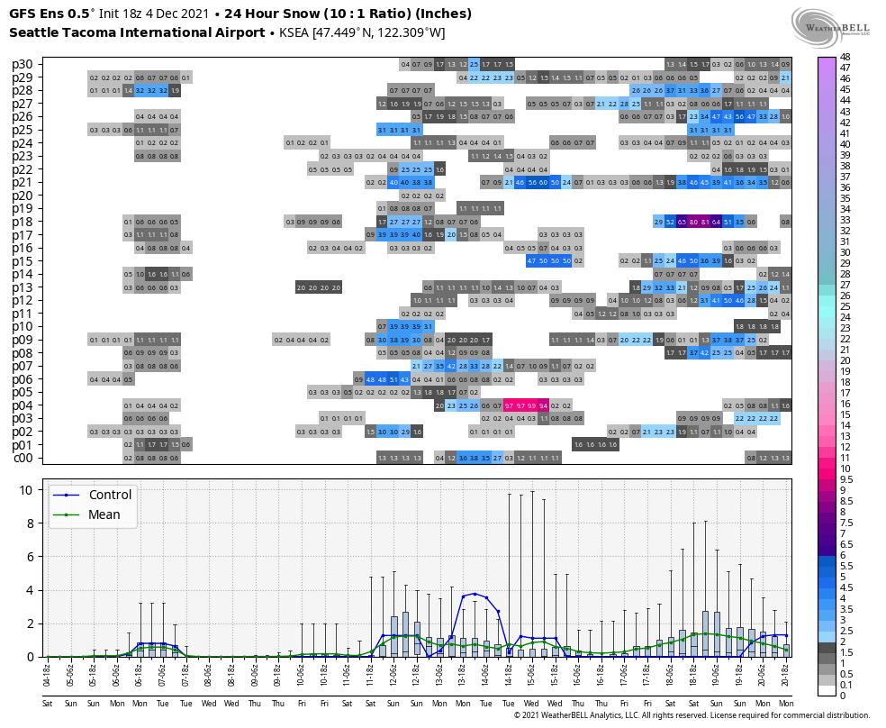
The latest (18 UTC) GFS plot for Sea-Tac shows snow in 20 out of the 30 ensemble members on Monday morning. Note the additional (but still uncertain) snow possibilities in about a week as well.
The 18 UTC ECMWF has snow in 20 out of the 50 ensemble members, which is a decrease over the previous run (12 UTC) which had snow in about 35 of the 50 members.

None of the snow amounts in the models are particularly impressive — less than an inch for the most past. The above plots are for Sea-Tac — odds of snowfall are somewhat higher north of Seattle as well as in the foothills. As I noted at the beginning, it’s a basically a coin toss as a whole. The event could be derailed either by warm temperatures or a lack of precipitation.
If I had to make a call, hunch is that Sea-Tac airport will see a trace of snow out of this event, mostly because the airport is 430 ft above sea level. A few other places might get lucky and get a dusting on grassy surfaces. Areas near sea level and south of Seattle will likely be all rain. So the wait will continue for a more significant lowland snow event.
