December 1 marks the start of meteorological winter. While the change to wintery weather does not always align with the start of December on the calendar, the PNW usually shifts to consistently lower snow levels and cooler temperatures late November to early December. So when will that shift occur?
First, a quick look at where we stand. November was a mild month across the entire western US, especially across the interior.

November precipitation was well above average in most of the PNW, especially Washington State, but the rest of the western US had a relatively dry month.

In Seattle, November is likely to go down as the 5th wettest on record. Autumn as a whole (Sept-Oct-Nov) is now the wettest on record in Seattle, currently 18.83″. November of 2006 remains the gold standard for extreme monthly rainfall at Sea-Tac airport.
Despite all of the precipitation, mountain snowpack is well below average in most of the PNW, although the North Cascades have remained near normal. Other parts of the west are also in bad shape.
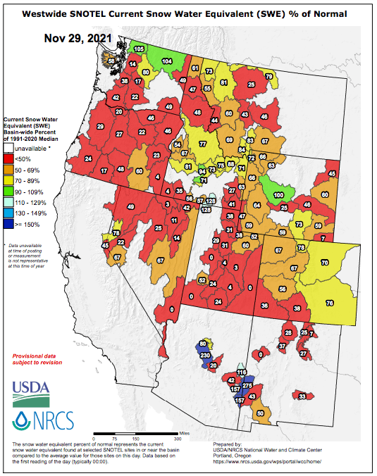
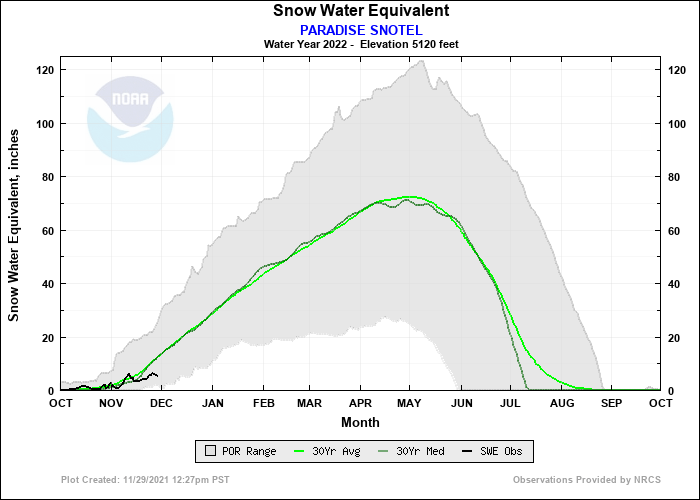
The good news is that there is plenty of time to catch up. Paradise on Mt. Rainer currently has around 5 inches of snow water equivalent (SWE) compared with a long-term normal of 12 inches. A 7-inch deficit can be erased in a couple of storms.
A pattern change on the horizon
Last week, it appeared that the large scale pattern would shift during the first week of December with a potential for arctic air to reach the PNW. Unfortunately, that shift has been put on hold. The ECMWF ensemble mean 500 hPa height anomalies for the next week show the western US ridge / eastern US trough pattern stuck in place.

In the PNW, this will be more of a ‘dirty ridge’ patten, meaning that the ridge will not fully block weather systems from clipping the region. Dry weather will be interspersed with occasional rainy periods. Temperatures will briefly cool down later this week before warming again by the weekend.
The second week of December looks a bit better according to the ECWMF ensemble mean. The ridge/trough pattern is expected to deamplify and become more zonally orientated. Weather systems will approach the PNW from the west-northwest rather than from the southwest.

This will probably be an active weather week that will be good for mountain snowpack, but arctic air is expected to remain bottled up in Alaska and northern Canada.
The GEFS paints a similar version of events for the second week of December, but with less of a trough over the western US.

The GEFS mean also has above-normal precipitation in the PNW during this period. Storm systems with lower snow levels will be much more friendly to our rivers than the recent parade of atmospheric rivers.
As an example, here’s the ECMWF ensemble 24-hr precipitation forecast for Sea-Tac. After a 3-4 day break at the end of this week, another storm cycle is expected to begin again next week.

The rest of December and beyond
Most of the longer-range models (e.g. ECMWF weeklies pictured below) are advertising a deeper trough forming over the western US in the 2-3 week time horizon. The ridge centered over the Aleutians is another favorable indicator that often helps to direct arctic air into the western US.
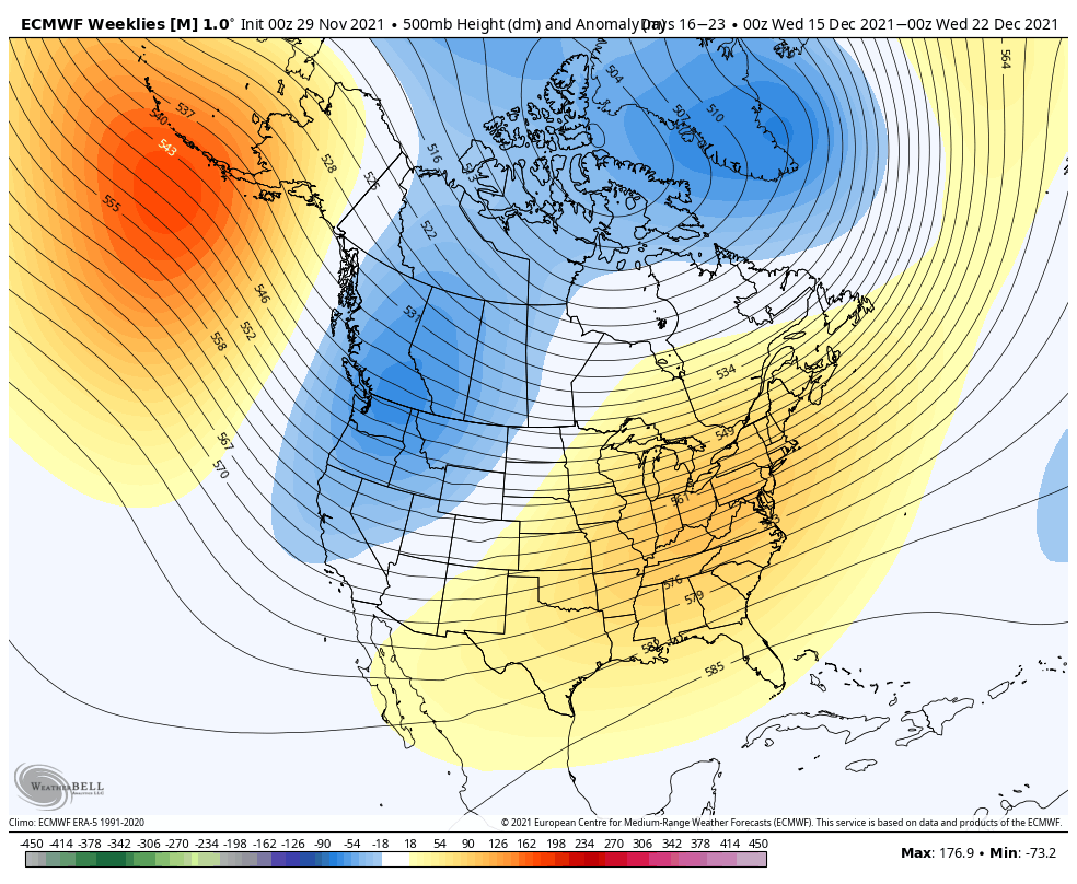
Any weather forecast beyond 2 weeks should be viewed with a high degree of skepticism, but there is reason to be optimistic about colder temperatures eventually gaining a foothold in the PNW.
The SST anomaly pattern continues to indicate a strengthening La Niña in the equatorial Pacific. Additionally, a region of colder-than-normal SSTs has formed off the coast of Alaska and BC.
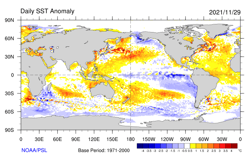
The effects of La Niña are most typically felt later in the winter (January-February), so the general expectation, reflected in NOAA’s seasonal forecast, is that winter will be cooler than normal as a whole.
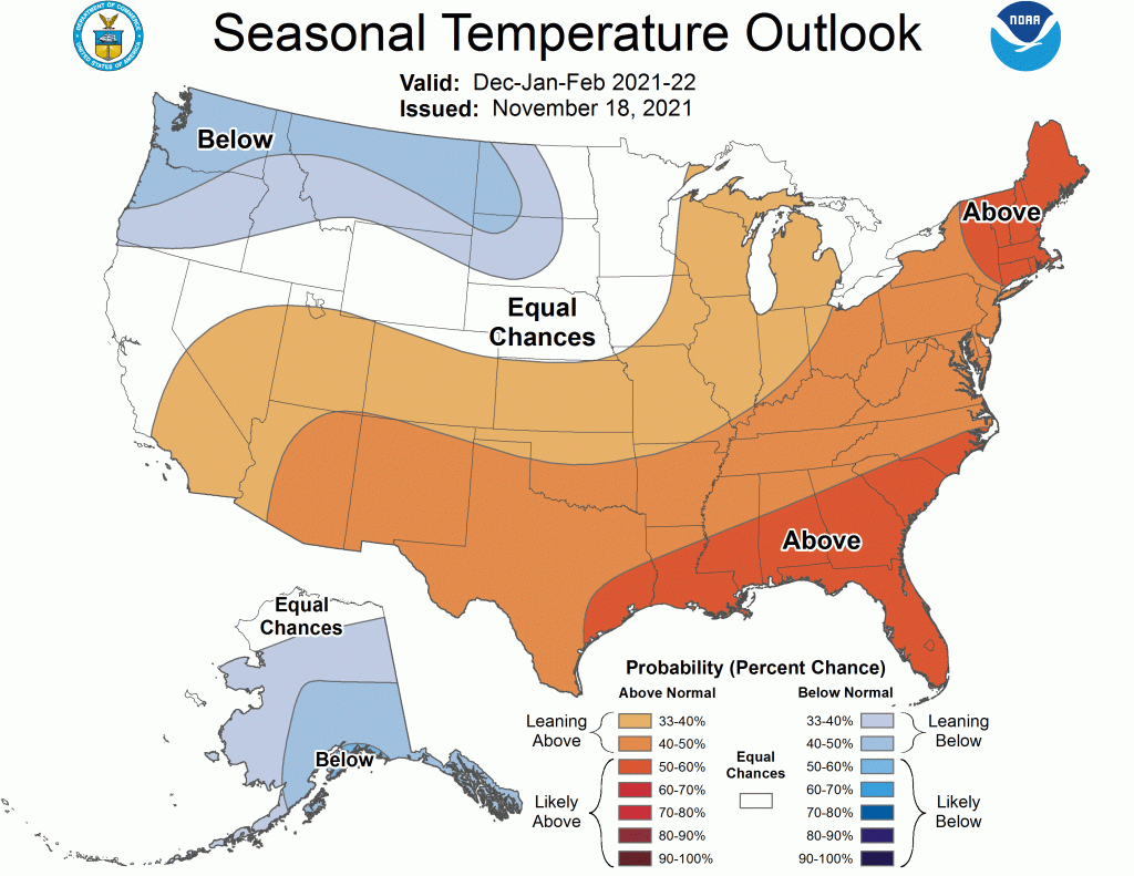
So all indications are that a shift to a cooler/snowier pattern is still on the way. We’ll just have to wait another week or two.

