

Who flipped the switch? Just a few weeks ago, the winter of 2021-22 was wet, cold, and stormy in the PNW. The ridging that began in mid-January looked like a brief reprieve prior to the inevitable return to the chilly and wet weather that La Niña winters are often known for.
The switch has yet to flip back. Here we are, one week into February, and the PNW is experiencing an early spring. Lowland temperatures are in the 50s, the sun has been making more frequent appearances, and there is no sign of winter returning in the 1-2 week forecasts.
Precipitation over the past month has been below average across most of the west, with the worst anomalies in California.
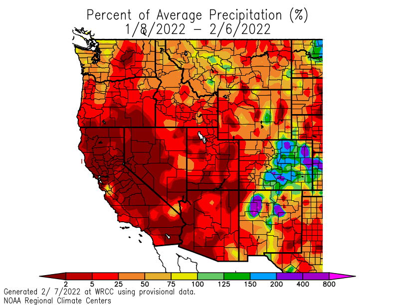
Snowpack has fallen below normal in most areas and will continue falling behind in the next several weeks.

La Niña winters are typically known for ridging off of the west coast of North America, especially in late winter. However, La Niña is far from the only driver of seasonal weather. This year, the ridge axis has centered closer to the west coast than last year, which has resulted in weather disturbances missing us to the north and wintery weather concentrating east of the Rockies.
The forecast for the next two weeks shows more of the same.
The latest iteration of the west coast ridge will peak on Wednesday-Thursday of this week. The ECMWF ensemble forecast for Wednesday evening shows height anomalies nearly off the charts.
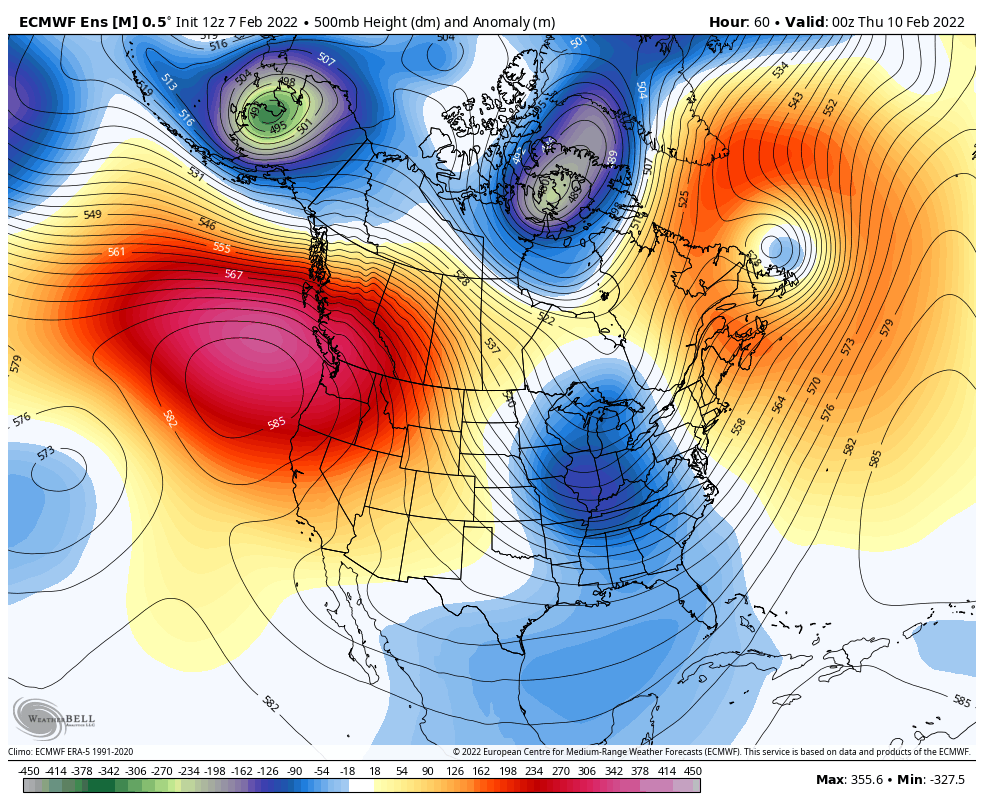
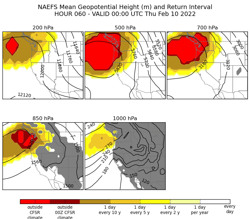
The strength of the ridge is expected to be outside of the 30-year NAEFS climatology for this time of year.
At the Quillayute radiosonde site, the record 500 hPa geopotential height (i.e. the height in meters of the 500 hPa pressure level) for the month of February is 5,850 meters. The current forecast for Wednesday evening is just shy of that, 5,825 meters.
Will there be record high temperatures as well? Not many. Record highs are in the 60s this time of year in Seattle, but an inversion will form with the warm air aloft. Temperatures should still easily reach the 50s in the Seattle area most days this week, with the warmest weather possible (upper 50s) possible by the weekend.
A similar story the following week
After losing a bit of amplitude over the weekend, the ridge will re-establish itself by the middle of next week. Here’s the ECMWF ensemble mean height anomaly forecast for Wednesday evening February 16, one week after the forecast that I showed above.

The height anomalies are still expected to be impressive, but the whole pattern should shift a bit westward. A westward shift of the longwave pattern in the jet stream is known as a ‘retrograde’ and is a fairly common occurrence when the pattern is amplified with big ridges and troughs like the current period.
If this slight retrogression occurs, the PNW should start to get clipped by weather systems dropping down from the northwest beginning early next week. The intermountain west would also see a bit of snow from this pattern along with cooler temperatures.
Arctic air is unlikely to return this winter
With winter running out of time, the best chance for a final shot of wintery weather would be if the pattern continues to retrograde westward by the final week of February.
Colder air may briefly return to the region, which should improve skiing conditions in the mountains but is unlikely to cause impacts in the lowlands.
The main problem is that an amplified polar jet stream doesn’t last forever and the pattern will eventually return to a more zonal (west-to-east) state. Such a pattern tends to keep arctic air bottled up at higher latitudes.
One metric that can be used to measure the strength of the polar vortex is the mean temperature of the lower stratosphere north of 60° latitude. Here’s a plot from NASA showing a climatology (gray shading), last winter (blue line), this winter (red/pink line) and a forecast (orange line).

As you can see, we are on a completely different trajectory from last winter when a stratospheric warming event in January resulted in cold air over the PNW in mid-February. This year, the polar vortex has been strengthening and is expected to continue to get stronger. Such a pattern is generally associated with warm weather in the mid-latitudes.
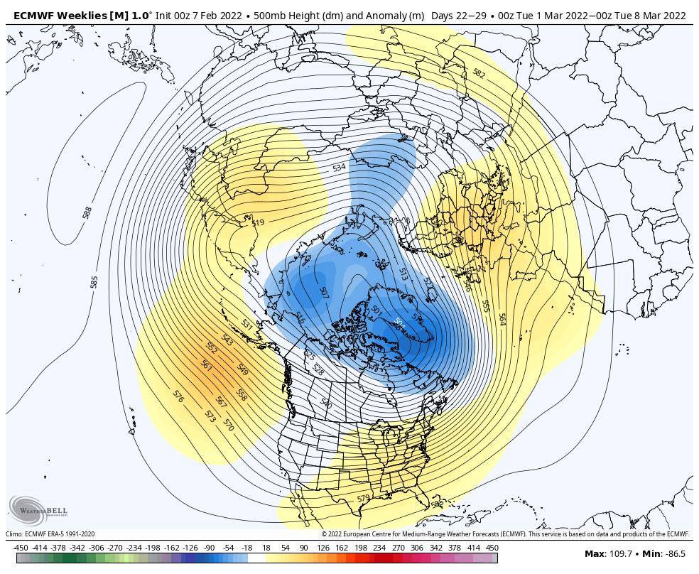
Is this evolution showing up in the models? Here’s the weekly height anomaly forecast for the last week of February from the ECMWF weeklies.

Indeed, a trough does make an appearance over the PNW, with ridging moving farther west over the north Pacific. At this time it does not look like this trough will be associated with an arctic air outbreak.
Moving into the first week of March, the model shows the negative (cold) height anomalies retreating to the polar regions, with a zonal pattern becoming established over western North America.
The good news is that a zonal pattern in March is favorable for stormier weather and mountain snow. So March is unlikely to be a repeat of the dry and mild weather that we are experiencing in February.
However, it also means that Seattle area is probably done with accumulating snow for the winter.

Thanks for the post. Hoping the models turn out correctly for late Feb and March. I’ve enjoyed this drier weather after such a rainy fall and early Jan but would love to see the rain and snow return before real spring arrives in April/May. I used to live in California and their lack of rain makes me nervous about the fire season outlook.
LikeLike
I’m concerned about California given the outlook for the next month. We seem to say that every year these days…
LikeLike
Right where that ridge is just 2 the south of there are underwater volcanos that are very active and have a past history of activeness. There have been many earthquakes that are deep over there in recent years and what this does is create a bit (warmer) then the surrounding air and what is high pressure? A warmer airmass and storms always take the easiest path out:
Combine all this and you have a literal ‘high pressure’ factory that is NOT going to go away on it’s own. It’s going to keep reenforcing itself. Sometimes a big system can over run it temporary but then it will reestablish itself. I knew from understanding physics that this ‘ridge’ was in no hurry to leave and knew the La Nina was going to be all screwed up royal.
LikeLike
I just discovered this great blog. I’ll be a frequent reader going forward!
LikeLike
Joe-
What is your assessment of the odds of getting a significant cold outbreak around February 20?
Would also be interested in your view of the major study regarding the Western megadrought released this week which attributes a substantial portion of the megadrought to human-caused climate change:
https://www.nature.com/articles/s41558-022-01290-z
LikeLike
Good thread on the megadrought study here: https://twitter.com/peedublya/status/1493433126651006977
It does look like there will be a decent cold air outbreak next week, there isn’t much moisture to work in the lowlands with but it could get us into record cold territory. Sun night-Mon morning is the time to watch for lowland snow showers.
LikeLike
Record lows for Bellingham for the last 10 days of February are anywhere between 8F and 22F. We are probably unlikely to get substantial snow in this period, but record lows could cause a fair amount of damage to the flora that is emerging, particularly if it is accompanied by strong NE winds. Would be interested in your assessment of the probable range of low temperatures and their duration. A couple of days does not do too much harm, but if it hangs on, that is different story.
LikeLike
I see that the NWS is moving around a bit on the timing of a Fraser River outflow. They had a wind advisory for Whatcom County previously to start at 1 pm Sunday, but now it is starting at 6 am Monday, so things have slipped a day. They still have record lows in the short-term forecast.
LikeLike