

It is not unusual to have a few spring wildfires in eastern North America, but the magnitude and extent of the ongoing spring wildfire season in Canada is unprecedented in recent years. The total area burned to date is more than 10 times the ten-year average and ahead of the entire annual acreage burned of every recent year except for 2021.
After an earlier intrusion of smoke into the central and western US a few weeks ago, another widespread fire outbreak in Quebec combined with northerly flow has resulted in thick smoke along the US eastern seaboard.
For residents of the western states and provinces, the images of hazy skies and air quality warnings look all too familiar.
Persistent ridging is largely to blame
The meteorological explanation for the spring wildfires is fairly straightforward — persistent ridging over much of Canada. This type of blocking pattern is known as an “Omega block” because the jet stream over North America follows the shape of an upper-case Omega. Such a pattern is fairly typical for spring and is also responsible for cooler-than normal weather during May in California.
Air flows anti-cyclonically (clockwise) around high pressure ridges in the northern hemisphere, so the position of the ridge over the center of the continent is perfect for advecting smoke from Canada into the eastern US. It also means that the PNW has been largely spared from smoke intrusions (for now).
What was unusual about this case is the strength and persistence of the blocking. Climatologist Brian Brettschneider provided some nice analysis on Twitter that helps put May 2023 in context. Along with extreme blocking, temperatures were also extreme in May with much of interior Canada ranking as the warmest since 1940 in the ERA5 reanalysis dataset.
Note that the Pacific Northwest was generally somewhere in the top-10 warmest in May depending on location but some areas did experience a record warm May as well.
Brian also provided some time series plots of the ERA5 reanalysis which is useful for additional historical context and for assessing the impact of climate change on this extreme event. Note that reanalysis is a model-derived product that is not intended to be as precise as surface observations but is highly useful for contextualizing events over large regions with sparse observations.
May in Canada shows a clear warming trend of 1.5°C since 1940 and May 2023 was 1°C warmer than the previous record in 1988.

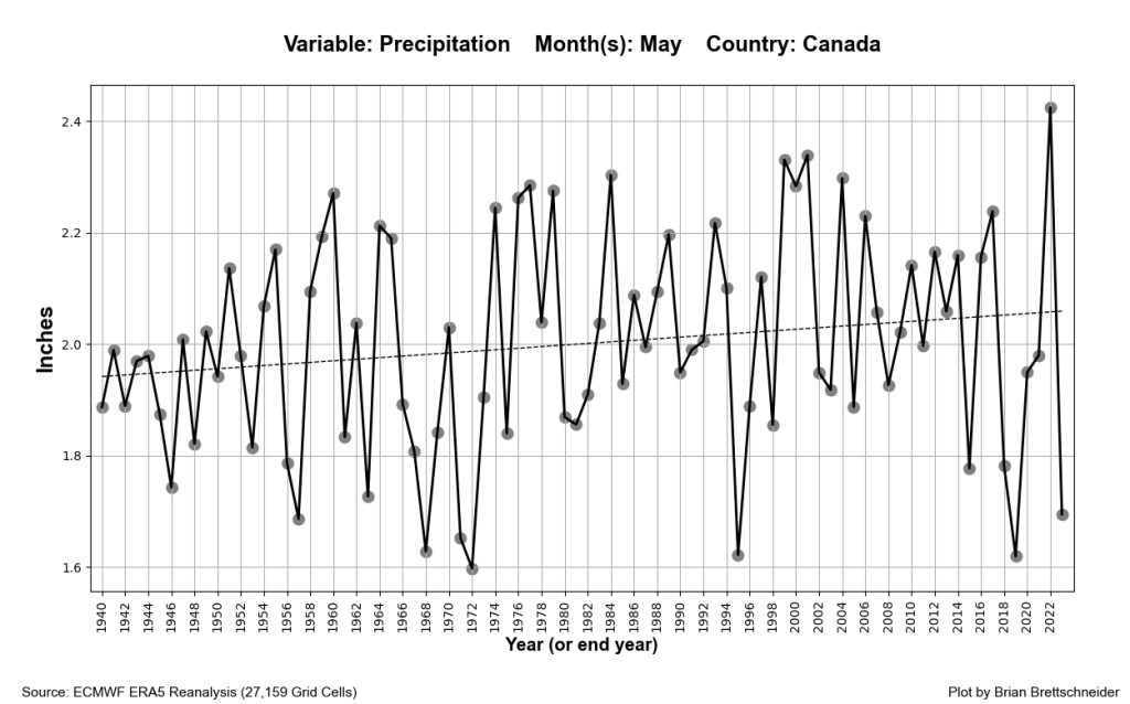
Canada precipitation in May shows an upward trend, but 2023 happened to be the third driest year since the early 1970s.
Other plots posted by Brian show that the May warming trend in British Columbia is a full 3°C since 1940 with the three warmest years all occurring since 2018.
The climate change contribution to wildfire outbreaks is often difficult to entangle from the weather- and human-related factors and this case is no different. However, in many ways the temperature numbers speak for themselves — breaking the previous May temperature record by 1°C over the entire country of Canada is another in a long list of phenomenal records that would not have been nearly as extreme without the contribution of climate change.
My biggest concern around the topic revolves around the principle of climate amplification. For instance, if the average temperature increases by 1°C, should we also expect the extremes to increase by 1°C as well? Or perhaps extremes in the climate will amplify under warming, so that a 1°C increase in mean temperature might correspond to a 1.5 or 2°C increase in temperature extremes? Such amplification is difficult to assess with observations from a limited historical record and remains up for debate in the scientific literature, but we already know that many other types of climate amplification are occurring, for instance arctic regions warming much faster than equatorial regions. So it stands to reason that some degree of amplification may occur, for instance due to changes in the jet stream or positive feedbacks between warming and drying of land surfaces.
Early concerns about wildfire risk in the PNW
Unfortunately, the rapid transition to a warm and dry summer-like regime is already resulting in increasing fire danger and spreading of some small fires in British Columbia and Washington State. One great example interior BC shows how snowpack can be a poor indicator of wildfire risk if conditions are otherwise hot, dry, and windy.
In Washington State, the Seattle NWS office issued its earliest Red Flag Warning since at least 2006.
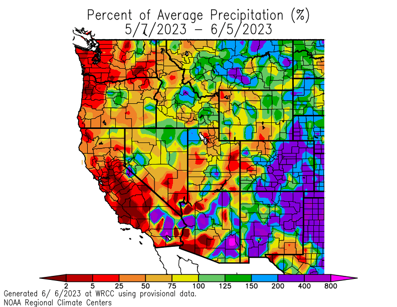
Precipitation over the past 30 days has been well below average across the entire west coast of the US, resulting in what amounts to an early start to summer.
These early season conditions do not guarantee a severe summer and fall fire season, but they represent a “loading of the dice” that increases the likelihood of wildfires down the road if the right weather pattern develops. Or if it’s already dry when the July 4 holiday comes along.
While some cooler and wetter weather is on the horizon for the PNW by the third week of June, it is too late in the season to make up the rainfall deficits and we are left crossing our fingers that summer and early fall will be cooler and wetter than many recent years.

Thanks for the thoughtful post. This topic has been on my mind a lot lately – I grew up in the PNW but lived in California for many years before I moved back here in 2017. Seems our spring rain/temp variations are becoming more extreme – last spring was so wet and cold, while this May has been quite warm and dry. Would be interesting to see if that shows in the data. I’ve been taking advantage of it by spending lots of time outside but the dryness has me worried for what’s in store later this summer. Hoping for some more summer precip and an early start to the fall rainy season. In the meantime, will enjoy some camping and disease free tomato plants.
LikeLike
Thanks so much for your analysis and commentary!! I quit twitter for ethical reasons but really miss the weather info. My small farm in NW WA is having a tough time with soil moisture (doesn’t help that Deb Haaland allowed Granite Construction to mine for gravel below the water table, after mowing down a mature forest, on the very banks of the Nooksack River! which has already affected the health of my land). -Joanna
LikeLike
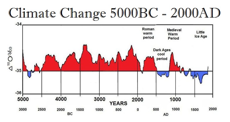
I really like your blog; it’s usually very informational. However, attributing the warm, dry May in the PNW, or really any specific weather anomaly anywhere across the planet to “climate change” is a stretch. It sounds like you are trying to craft data to fit the desired narrative. You did not say, “anthropomorphic” climate change, but I assume that is what you meant. Looking at temperatures only since 1940 is pretty meaningless in terms of climate; it’s okay in terms of “the weather”. If you look across the past 500 years, the planet was already in a relatively cool period stretching from the Medival Warm Period. Most recently, the “Little Ice Age” impacted global temperatures for three centuries, more or less. However, the past 5000-7000 years have actually been “warmer” than our modern average. The warm Spring we are seeing might be attributable to the new El Nino forming, or we might simply be returning to the historical mean. But on a big enough scale everything climate-oriented is ultimately natural cycles. It really comes down to things like the sun’s output, the Milankovitch cycles (eccentricity, obliquity, precession), and where our solar system is in relation to the galactic center.
See links:
https://climate.nasa.gov/news/2948/milankovitch-orbital-cycles-and-their-role-in-earths-climate/
LikeLike
It is absolutely not true that the past 5000-7000 years have actually been “warmer” than our modern average, the global earth temperatures are estimated to be already above anywhere it has been in the past 22000 years. The graph you show is not anywhere in the article you link, and it definitely doesn’t show earth average temperatures, it is clearly the temperature data of greenland ice core reconstruction and is mislabeled. First of all the label says 5000BC – 2000AD, where it is obvious from the graph that the data doesn’t extend anywhere near to 2000AD, the proxy temperature reconstruction from the Greenland Ice core only extends to 1855 and doesn’t include any modern observational data at all. More importantly, temperatures just in one location do not indicate global average temperatures at all. https://en.wikipedia.org/wiki/Greenland_Ice_Sheet_Project Shame on you for spreading misinformation!
LikeLike
Jeff-
I think Joe was quite balanced in his discussion of the potential role of climate change in the Canadian fires:
“The climate change contribution to wildfire outbreaks is often difficult to entangle from the weather- and human-related factors and this case is no different. However, in many ways the temperature numbers speak for themselves * * *.”
As for your appeal to factors like Milanovitch cycles, you failed to quote relevant NASA discussion on this issue:
“Milankovitch cycles operate on long time scales, ranging from tens of thousands to hundreds of thousands of years. In contrast, Earth’s current warming has taken place over time scales of decades to centuries. Over the last 150 years, Milankovitch cycles have not changed the amount of solar energy absorbed by Earth very much. In fact, NASA satellite observations show that over the last 40 years, solar radiation has actually decreased somewhat.”
https://climate.nasa.gov/explore/ask-nasa-climate/2949/why-milankovitch-orbital-cycles-cant-explain-earths-current-warming/
LikeLike
I can’t believe some people are still out there trying to debate the existence of climate change and it’s clear connections with weather phenomena like heat waves. These same people would’ve have been pushing for the existence of a flat earth long after was disproven.
LikeLike
Joe,
What’s your take on the possibility for and potential impact of troughing over the PNW toward the end of the week?
LikeLike
Looks like it will happen with another stretch of cooler weather and some measurable rain. Nothing all that unusual for this time of year but great to see more moisture before we move into July.
LikeLike
That’s what I thought too. Thanks!
LikeLike
Test
LikeLike
Only 0.5” of rain in Eugene since April 24th.
LikeLike
Eugene right now:
101F
AQI 172
Similar numbers up and down Oregon’s I-5 corridor. Yuck!
LikeLike