

After a chilly and rainy spring, the PNW is currently undergoing a rapid transition to an extended period of dry and warm weather beginning this weekend. The main story is a heatwave peaking from Saturday – Monday, although warm and dry conditions will likely persist through at least next week. Let’s look at the details.
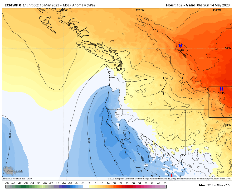
Ridge building will commence on Thursday and especially Friday along the west coast of North America. By Friday evening, an impressive area of anomalously high 500 hPa heights will cover most of the western US and Canada.
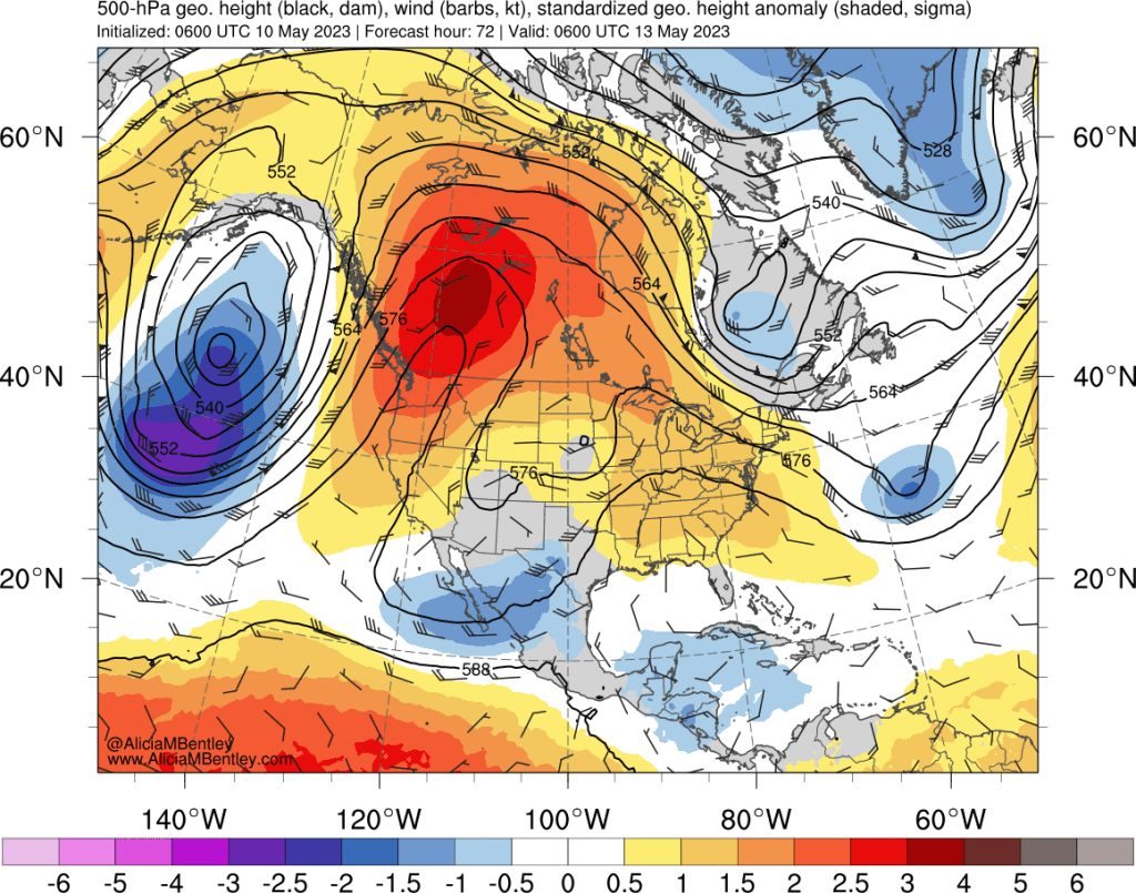
By Sunday, a giant area of +3 sigma height anomalies will cover most of BC, Alberta, and Saskatchewan.
The above forecast looks remarkably like the infamous June 2021 heat wave. The 2023 version has similar anomalies, but the absolute height values are lower because this event is occurring earlier in the season.
Another subtle difference is the weak area of low pressure to the south of the ridge, centered over Nevada. That feature may trigger thunderstorms over the region on Monday or Tuesday and will also help prevent cooler marine air from pushing inland after the peak of the heatwave.
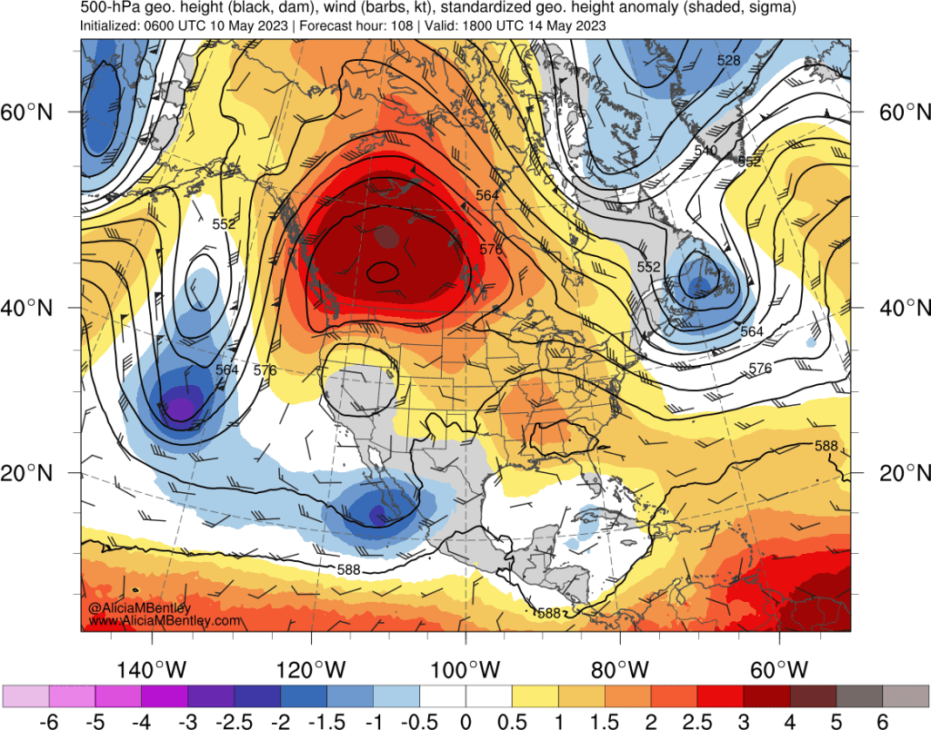
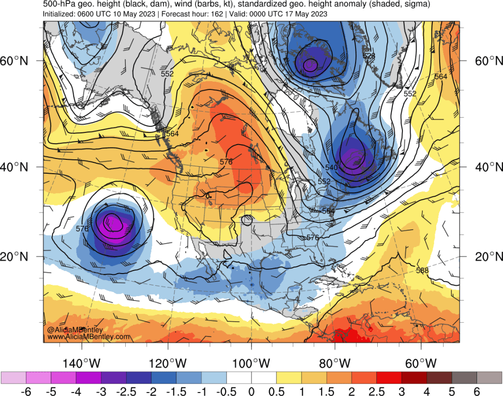
The ridge is expected to progress eastward and dissipate somewhat by Wednesday the 17th, but positive height anomalies will remain in place over the PNW.
How warm will it get?
Fortunately, this is NOT a repeat of 2021. Temperatures in the lower atmosphere (850 hPa) are expected to peak around 17°C in western Washington. Our major summer heatwaves are usually in the low-20s°C and the 2021 heatwave peaked around 28°C. Surface temperatures will approach all-time May records to the west of the Cascades. The heat will be less likely to break records to the east of the Cascades.
If this pattern was occurring in late June instead of mid-May, I have no doubt that we would be talking about the potential for 100s in Seattle and Portland. Fortunately, this ridge is expected to pull some cooler air down into the northern Rockies on Friday and Saturday, which will limit the potential for maximum temperatures to the upper-80s to low-90s in most of the lowlands.
The cooler air can be seen over Montana in this forecast for Saturday evening, upstream of the easterly flow over the PNW.
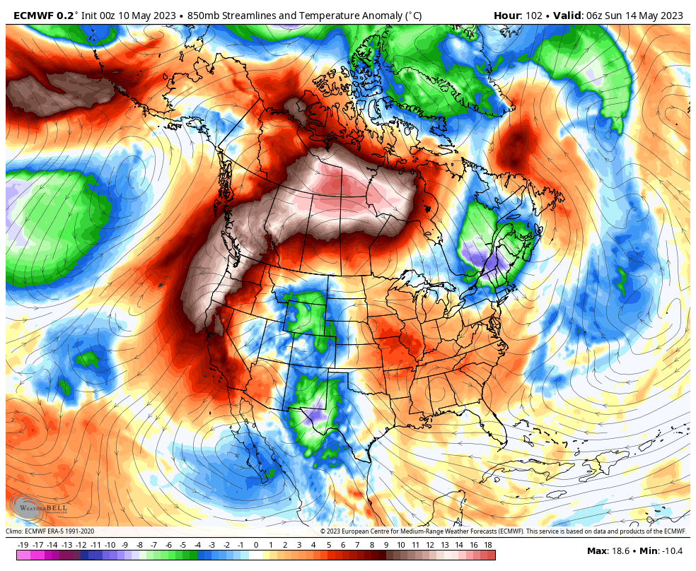
Temperature anomalies will be the greatest to the west of the Cascades thanks to impressive downslope warming from the strong easterlies to the south of the ridge. The downslope warming is largely the driver of this heatwave in our region, as is necessary in the early season when ambient temperatures are still relatively cool compared with summer.
This type of downslope warming will generate a “thermal trough” feature which can be thought of as a feedback mechanism that further enhances the offshore-directed pressure gradient in PNW heatwaves. The thermal trough is a mesoscale feature that can often result in wrinkles to the forecast that are difficult to predict.
In this case, the thermal trough will begin building offshore of California on Saturday and make its usual progression northward on Sunday (pictured above). So the easterlies will likely be strongest through the passes on Sunday.
Monday is when things will get more complicated. Often our heatwaves end with the thermal trough strengthening and progressing northward, eventually resulting in a “marine push” of onshore flow as the pressure gradient reverses directions.
There will NOT be a significant marine push on Monday night. Instead, that pesky area of low pressure to the south of the ridge (the one that will likely be over Nevada on Sunday), will drift northwestward over Oregon and eventually offshore by Monday evening. The MSLP anomaly plot for Monday afternoon does not show a thermal trough (which tends to hug the coastline), but rather a broader area of low pressure anomalies offshore.

While the extreme heat will dissipate by Tuesday, the relatively warm airmass will be stuck in place, so high temperatures will remain well above normal through next week. The National Blend of Models (NBM) shows high temperatures gradually decreasing back to the mid-70s by the following weekend, but I suspect these could be underestimated.
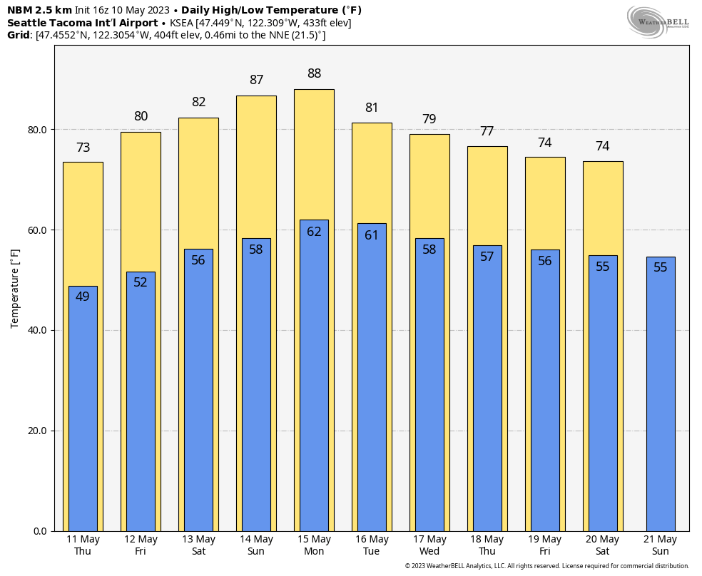
The peak of the heatwave on Sunday-Monday should result in temperatures somewhere from the upper-80s to low-90s in Seattle, and low-to-mid 90s in Portland. Portland will have a more extended warm spell with high temperatures remaining in the 80s through the middle of next week.
A sign of things to come?
The La Niña event that began in late 2019 has officially come to an end and sea surface temperatures around the globe have been soaring to unprecedented levels. Shockingly, these anomalies are being seen prior to the beginning of a likely El Niño event that is expected by the end of 2023.
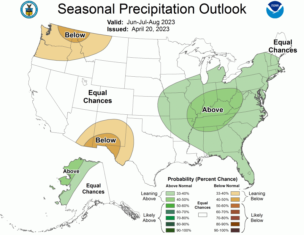
The latest NOAA seasonal outlooks suggest an elevated probability of another warm and dry summer in the PNW.

As anthropogenic climate change continues to warm the planet, the odds are increasingly becoming stacked in favor of warm and dry summers in the PNW. I expect that we will return to cool and cloudy weather in June as we usually do, but the longer term outlook for this summer remains in favor of warmth.
It is extremely concerning to see another massive ridge form only two years removed from the 2021 heat wave. I fear that ridges of this magnitude will be become regular occurrences in the warm season moving forward.

Thank you for another well-informed forecast. Global warming is here. It’s real and we are about to witness its devastating consequences.
LikeLike
Joe… the published literature is pretty clear… there is no trend for increased ridging over the region. And it is also important to note that all ridges are not the same. This one is NOT like the 2021 ridge in location or amplitude. It is NOT ideal for producing extreme heat over Washington….cliff
LikeLike
Hi Cliff,
Based on the current forecasts, there is the potential for somewhere between 2-4 daily record highs to be set at Sea-Tac airport between Friday and Monday. There is the potential for the earliest ever 90 degree day in Seattle on Monday. Clearly this is a significant heatwave for mid-May. This ridge is centered in nearly the same spot as the 2021 heat wave and the area of +3 sigma anomalies is larger in this event than 2021. As I noted, some details are different which is important.
I did not make any comment about ridging becoming more frequent over the region, it is my personal opinion that the ridges that do occur will continue to become more severe in terms of the level of heat that they are capable of delivering. That is certainly backed up by the increasing frequency of maximum temperatures exceeding virtually every warm threshold (80F, 90F, 100F). As the climate continues to warm, this will only continue. It’s not going to get any cooler, everything we are already seeing is only going to be exacerbated in the coming decades.
LikeLike
Joe… if you look at the record annual highs, there is NO trend towards them becoming more frequent. And there is no trend for ridges becoming stronger. Keep in mind that easterly flow maxes may WEAKEN under global warming. This is not 2021….with major differences in the synoptics ..cliff
LikeLike
This heat wave doesn’t have much of a thermal trough or strong easterlies. It’s a beast of an event that could potentially linger for a full week or longer. The cutoff low is going to contribute to the duration while reducing the peak intensity. We are likely going to smash a bunch of records for number of 80+ degree days in May. The duration is unprecedented for this time of year.
LikeLike
What’s the likelihood that smoke from the wildfires in Alberta will be transported into Western WA via the cyclonic flow around the area of high pressure?
LikeLike
Yes, that is likely Saturday night into Sunday. But it will be aloft and diffuse so the only impact will likely be to make the sky a bit hazy.
LikeLike
*Anticyclonic, and thanks for the reply!
LikeLike
This was a significant event and as you indicate, if it were later, the maximum highs would likely have been much higher. In the meantime, Western Washington precipitation remains quite low even if there was a robust snow season in the Cascades. Bellingham is about 50% of normal for the 2023 calendar year and about two-thirds of normal for the current water year. There has not been a single 2023 month in Bellingham that has been at normal or above for the current calendar year. Similarly, SeaTac is about two-thirds of normal for the 2023 calendar year and 80% of normal for the current water year. April was the only month that was at normal at SeaTac so far this year.
LikeLike
“Joe… if you look at the record annual highs, there is NO trend towards them becoming more frequent.”
This is based on a time series of just one data point per year, correct? In which case Olympia, for example, could report a high of 100F every single day this summer and the above might still be true.
LikeLike