

After a brief tease of snow showers across Puget Sound on Wednesday morning, arctic air continues to intrude into western Washington and Oregon.
As of 4 AM Wednesday, the cold anomalies were widespread across both the interior PNW and offshore over the Pacific.
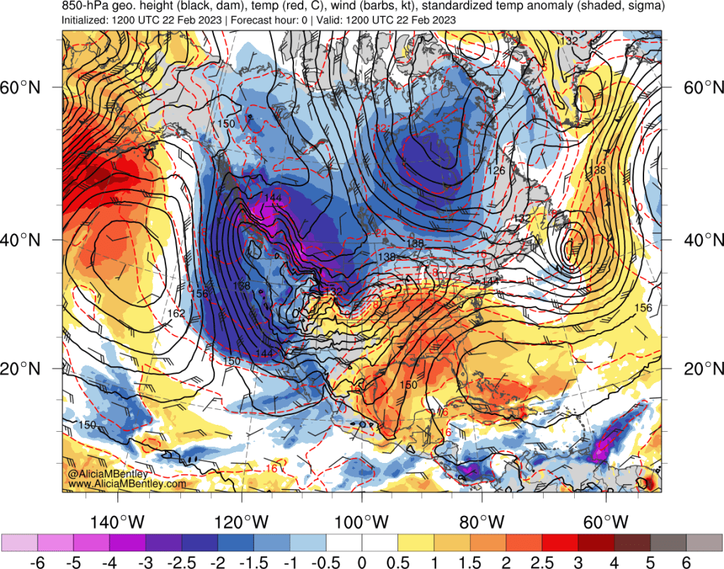
Low pressure centered over southwest Washington was responsible for both the morning snow showers and for strengthening the pressure gradient through the Fraser Valley and Cascade mountain passes. Snow was ongoing in the Portland, OR area as of Wednesday afternoon, with additional snow showers approaching southern portions of Puget Sound.
In addition to the PNW impacts this particular cold air outbreak is also notable for the impressive southerly push down to southern California, where rare blizzard warnings were in effect for the mountains around Los Angeles.
Cold air fully entrenched by Thursday-Friday
Over the next few days, the low pressure center and its associated trough will dive southward into California, leaving an airmass in place that will be plenty cold for snow. The 850 hPa anomalies on Friday morning look quite cold. Temperatures will struggle to reach much above freezing in the lowlands on both Thursday and Friday.
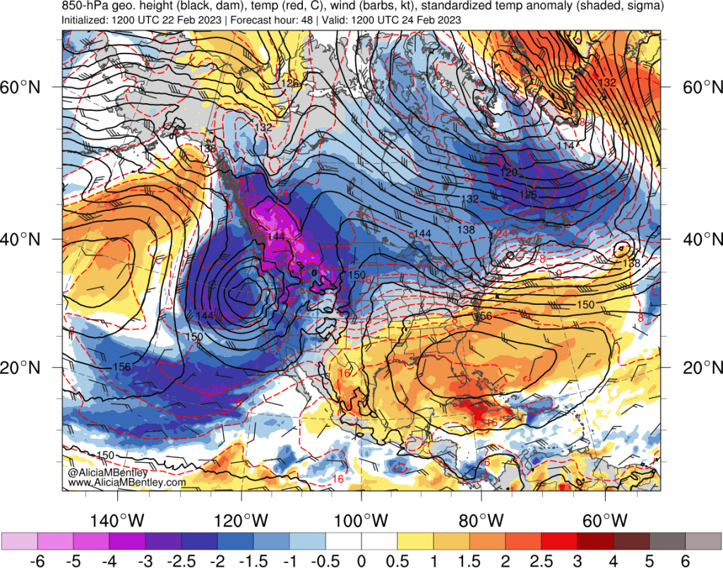
At least it will be mostly sunny to go along with the cold weather.
Snow approaches the region on Saturday
More interesting weather will be possible beginning Saturday as a pair of shortwave troughs approach the PNW from the northwest. These weather systems can easily be seen as a pair of on a 500 hPa chart — the one below is valid for Friday evening as the systems are on the approach.
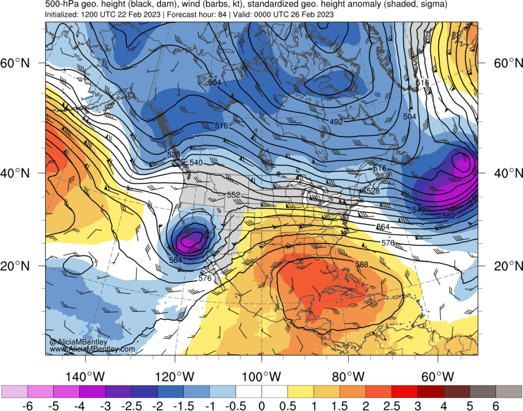
The first one, on Saturday evening into Sunday, is about as safe of a bet as we get for accumulating lowland snow in these parts. This will be an “overunning” event meaning that warm air and moisture will override the entrenched cold air in the form of a warm/occluded front.
The ECMWF surface pressure and precipitation forecast valid for late Saturday evening into Sunday morning shows snow overspreading much of the PNW lowlands.
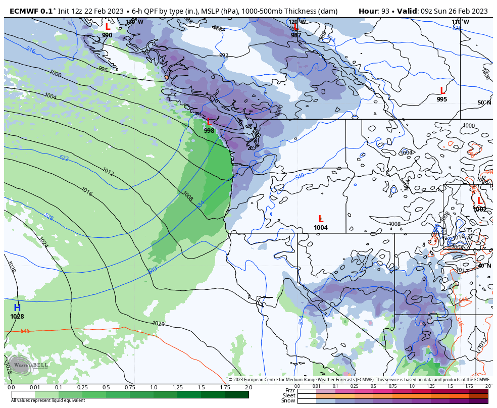
Note that there is no closed area of low pressure in the above map — the actual surface low will come ashore well north near Haida Gwaii.
Most of the lowlands in the region should wake up to a nice coating of 1-3 inches of snow on Sunday morning. Following the frontal passage, by midday Sunday, temperatures should warm enough for the snow level to rise back above 1,000 ft.
A stronger area of low pressure is expected to approach the PNW on Monday. As of right now, it appears that snow levels could again drop down to sea level late on Monday into Tuesday, but any additional accumulation will likely be patchy in the lowlands.
High ensemble confidence for 1-3 inches of snow
Although we are in the 48-72 hour lead time and forecasts are subject to change, we can have high confidence in this event because all 50 members of the European ensemble are showing accumulating snow at Sea-Tac airport on Saturday night.
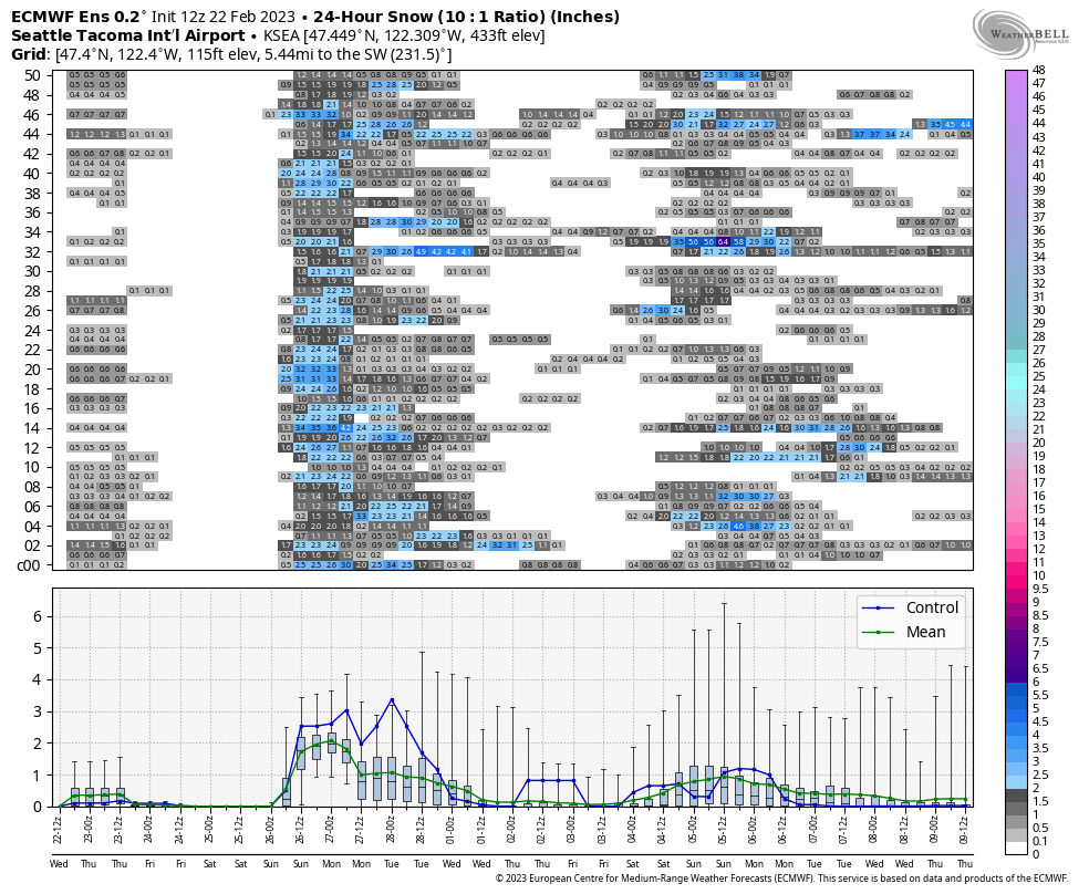
The ensemble mean for snow in the previous 24 hours is show in the green line in the lower panel, which is right around 2 inches for Sea-Tac airport. The forecast looks similar for Portland (1-3 inches), while Vancouver BC may see closer to 10 cm according to the ensemble mean.
The threat of additional snowfall into Tuesday can be seen as well, with possibly an inch of additional snowfall over that period (along with some rain as well).
The European model is also teasing more snowfall for the first weekend in March, but the forecast remains uncertain at this time. What we do know is that a transition to spring is nowhere to be found in the 10-14 day outlook.

2/22 was a chilly day in Whatcom County. BLI reported a high of 30F, breaking the daily record low max temp of 32F set last year.
LikeLike
This has certainly been a testament to persistence here in Bellingham. The winds finally started to moderate last night, after a fairly steady 20mph+ wind at the airport, with gusts much higher, for about 3 full days. In spite of this, there have been few power outages. One thing about Whatcom County is we get frequent winds, which keep things naturally pruned. Whether we get any significant snow seems to be fairly uncertain at this point.
https://www.weather.gov/wrh/timeseries?site=AV482
LikeLike
Yeah next week looks like one of those periods where the snow level might vacillate between sea level and ~1,000 ft. Still looks like a quick inch or two for most on Saturday night before it warms up.
LikeLike
So, about 3-4 weeks ago or so, there was considerable discussion of a major disruption to the polar vortex as a result of stratospheric warming over the pole. There has not been much discussion as to whether the North American cooling we are now experiencing, including in the PNW, is a result of that disruption. The popular press sometimes obsesses over the “polar vortex” when this happens (often sounding like we are in the middle of black hole.) I would be interested in knowing whether these current events can be attributed to such a disruption, which is not that rare.
https://www.weather.gov/wrh/timeseries?site=AV482
LikeLike
According to Severe Weather Europe, the first impacts from the SSW event are forecast for early March, which includes continued cold here in the PNW:
https://www.severe-weather.eu/global-weather/polar-vortex-sudden-stratospheric-warming-main-weather-impacts-united-states-canada-europe-forecast-fa/
LikeLike
Very confusing snow forecast for Bellingham from NWS today. The 7-day zone forecast for Bellingham has less than .5″ inch for Saturday, up to 1″ for Saturday night/Sunday morning, and no snow for Sunday:
https://forecast.weather.gov/MapClick.php?textField1=48.75&textField2=-122.48#.Y_oqtx_MJHZ
Yet, they have issued a Winter Weather Advisory for Whatcom County, including Bellingham, for up to 10″:
https://forecast.weather.gov/showsigwx.php?warnzone=WAZ503&warncounty=WAC073&firewxzone=WAZ653&local_place1=Bellingham%20WA&product1=Winter+Weather+Advisory&lat=48.75&lon=-122.48#.Y_oruh_MJHY
LikeLike
Here in my part of Bellingham, close to the airport, the NWS snow forecasts seem like a big miss. The NWS started out with up to 10″ of snow, but then reduced it to 4″. In fact, there was perhaps 1/4″ to 1/2″ of snow that quickly melted. I appreciate the big uncertainties and perhaps NWS got a little gun-shy from misses to the south, particularly Portland.
LikeLike
It’s just been a little too warm to get decent lowland snow. On Sunday morning I had 0.38″ of precip in my gauge which would usually be worth 3-4″ of snow, but it was only 1″ because of the warm temperatures. The models are again showing several inches of snow through mid week but I think almost none of it is going to stick at low elevations, except briefly under heavier show showers or maybe overnight. Too much sun in late Feb.
LikeLike
NWS is repeating to some degree the last somewhat confusing set of forecasting releases with a zone forecast for Bellingham of up to 1.5″ of snow over the next 24 hours, but also a Winter Weather Advisory that includes Bellingham getting “maybe” 2″-3″. I think this is highly altitude dependent, so if you are close to sea level it will melt quickly, but at 500′, you may get a bit more accumulation. I notice the reference to climatology in the NWS daily discussion. Basically, this time of the year you are betting against the house if you are forecasting snow in the lowlands of Western Washington. That isn’t to say it can’t happen, but as you indicate, there are many factors working against it, including history. We just got a brief snow shower a few minutes ago, but air temperature is 36F and the ground has had a good chance to warm a bit. I do recall growing up in Portland and getting at least one very intense snow storm in March, but this was mostly due to the Columbia River Gorge, so outside of Portland, it did not happen.
LikeLike
This pattern would have been epic in December.
LikeLike
I’m not sure if we were in any other part of the northern US where snow is a fairly common wintertime event we would have a broad Winter Weather Advisory for what is actually being predicted (small marginal amounts). It seems to me that it ought to be more targeted to higher elevations or places with more specific local effects. Of course, I could be totally wrong, but I think from a forecasting standpoint, you have to give it your best shot and then live with prediction.
LikeLike
Well, despite my skepticism, I would say that NWS got the forecast right for Bellingham (near the airport). This morning when I got up, there was less than a 1/4″ of slush on the road, so I assumed that would be it. But starting around 8:30 am, we got moderate snow for around 2 hours or so resulting in couple of inches of fairly wet snow. We are at a little over 200 feet, so I would not be surprised if there was less snow in downtown Bellingham at sea level. One of the NWS advisories for this area called out elevations above 200′ for accumulations. My lowest temperature was just at 32F between 5am and 10am. It has started to rise since then with the snow melting now. Looks like Whatcom County I-5 is quite clear, with I-5 in downtown Bellingham showing very little snow next to the freeway.
LikeLike
Hey, I have a question about Snotel data – do scientists have a way to determine how much of the SWE fell as snow, versus as rainfall that was absorbed by the snowpack?
LikeLike
@Opie You could come up with a rough estimate, keeping in mind that SNOTEL data can be noisy at hourly resolution. The SWE is just a scale basically that weighs the snowpack. The optical sensor gives hourly measurements of snow depth. So you can figure out when it’s “snowing” when SWE and snow depth have both increased (and temperature is cold enough for snow). You can also figure out when it’s raining and being absorbed by the snow (snow depth is constant or decreasing and SWE is increasing). Not sure if anyone has tried to run the calculation…
LikeLike
Thanks!
I like to follow Westwide Snotel to see how our snowpack is doing – mostly interested in how deep it is, not necessarily how heavy – and realized SWE might not be the best indicator.
LikeLike
Highest temp at PDX,
October 28 – March 11,
… was 60F back on Nov 4
Luckily a little warm patch coming up this week. Even upper 50s will feel balmy.
LikeLike
Sorry, forgot those stats might seem fairly normal for folks in Puget Sound and points northward.
LikeLike
I can usually just do a Google search and find the answer to my many climate science questions, but there’s a few where that hasn’t worked and I’d like to ask an expert. Here’s one…
It’s often mentioned that extreme rainfall events are expected to increase because a warmer atmosphere holds more water. This doesn’t make sense to me because, for example, with global warming, atmospheric river events will tend to encounter land masses that have warmed even faster than areas over the ocean. Meaning the atmosphere over these land areas should also “hold more water”(decreasing orographic precipitation). In fact, even more so than over the ocean because as mentioned above.
LikeLike
That is a tricky question! There are some nice slides here: https://www.atmos.washington.edu/~dennis/321/321_Lecture_28.pdf
I think you’re basically explaining why we say “wet gets wetter, dry gets drier” under climate change. If we ignore any changes in the strength of the wind, then in areas where it is already raining (i.e. the atmosphere is fully saturated), there will be more rain. In areas where it is not raining (i.e. the atmosphere is not saturated), it will be more difficult for it to rain because more evaporation is needed to reach saturation.
In the case of PNW winters, our region is generally pretty close to saturation, so any weather systems that we encounter will generally be wetter (again, neglecting any changes to the weather patterns themselves).
In the case of PNW summers it is the opposite — we are farther from saturation, so any weather systems that form will have a greater barrier to overcome to reach saturation, hence they will be drier.
The land/ocean differences are an interesting twist on the classical understanding of this topic. In terms of ARs and orographic precip, remember that the airmass advects with the weather system, so the maritime airmass will be over land during the AR, and any drier (or warmer) continental air will have been displaced. However, on the lee side of the coastal mountains, there may end up being a drying during winter AR events…tough to say without digging more into the literature.
LikeLike
Thanks for the lengthy reply! I’ll get back to you after I’ve mulled it over for awhile and hopefully have something interesting to add (might be several weeks depending on how much time I have for mulling, lol).
The part about “remember that the airmass advects with the weather system” is already very helpful.
LikeLike
Hi Joe,
I was confused about the increase in extreme precipitation events because I’d completely overlooked advection/displacement.
Making up numbers –
a nearly saturated airmass with 2% water vapor would produce more precipitation than a nearly saturated airmass with 1% water vapor, given the same drop in temperature, with the temperature drop created by convection/adiabatic cooling. The intensity of the precipitation event, as opposed to the overall total, would be determined by the upward speed of the airmass (rate of convection?), with that in turn determined by the airmass’s buoyancy and speed of converging winds, or, in the case of an air mass being forced upwards by topography, by the airmass’s velocity.
That’s a mouthful – hopefully correct?
LikeLike
I’m actually not sure if I used the term “convection” correctly as it relates to meteorology. Does it include air being forced upwards by converging winds, or by wind encountering a mountain, or is it reserved for air moving upwards as a result of uneven surface heating?
LikeLike