

The first two-thirds of January 2023 featured mild temperatures and relatively benign weather in the PNW. The storm track, along with any significant, impactful weather, has been focused over California. Meanwhile, the PNW has settled for light rain and temperatures in the 40s – low 50s.
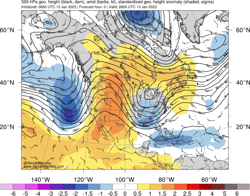
From a synoptic meteorology perspective, the culprit for the recent weather has been persistent troughing over the Pacific ocean to our west around 140° W, which has left the PNW in a warm, south-southwesterly flow regime downstream of the trough. Here’s a representative example from about a week ago.
At the present time we are in the process of a pattern reversal, with the troughing gradually being replaced by ridging off the west coast of North America. By mid-next week that process should be complete.

This is a boring pattern from a weather perspective. The jet stream will be split, with some energy riding up and over the ridge, missing us to the north, and the rest going south via the subtropical component of the jet. The subtropical jet looks to be active over this period over the eastern US, which may lead to a couple of impactful winter storms.
From a PNW perspective, the pattern gets more interesting near the end of January as the entire pattern is expected to amplify.
Initially, using the 5-10 day Euro ensemble mean as a guide, the troughing will be centered in the central US, while the PNW will see weak northwesterly flow that will keep temperatures in the seasonal range despite the nearby ridging.
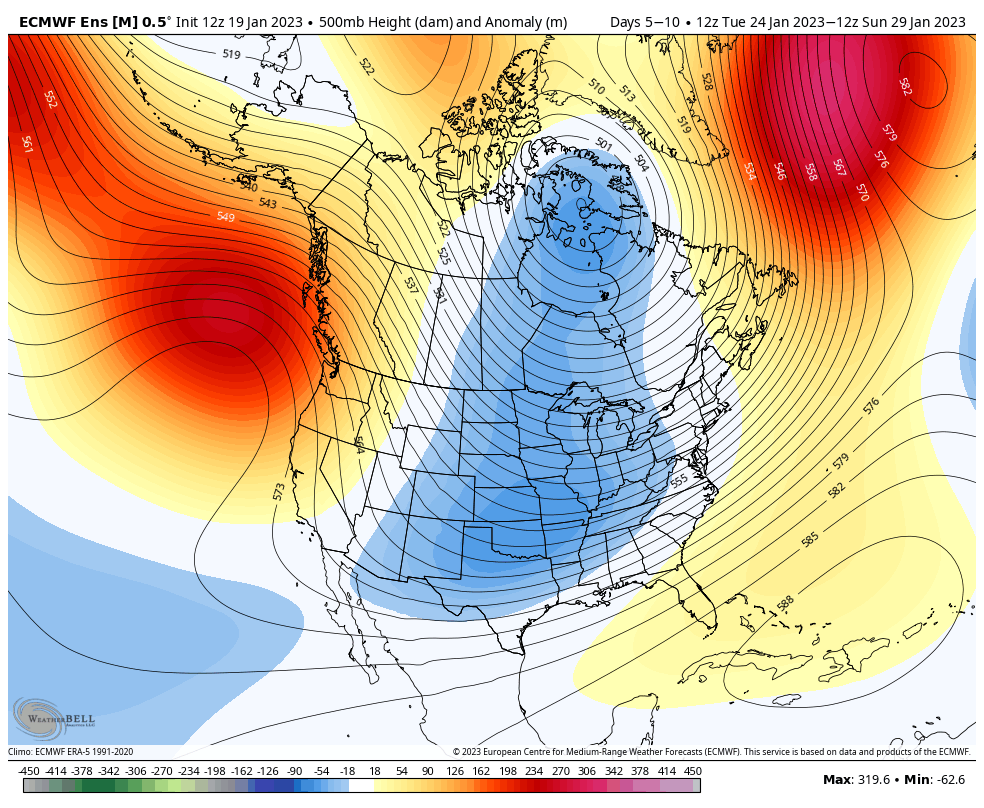
As often happens with amplified upper-level patterns, the European ensemble is predicting that the entire regime will retrograde westward by the start of February (10-15 day mean shown below), placing the PNW in a more favorable pattern for a cold snap.

The progression makes sense and is well-supported by global ensembles, so the cold air should be in our neighborhood in about ten days. Beyond that, any specific predictions of impactful weather are pure guesswork at this time.
La Niña may be ending soon
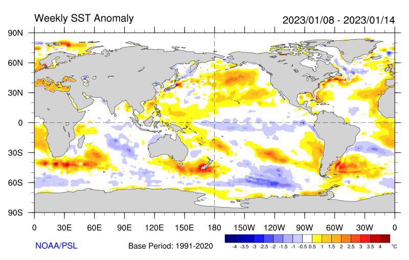
The “triple dip” La Niña that has been present for the last three winters appears to be coming to an end, as sea surface temperatures in the equatorial Pacific have moderated over the last few months. The latest anomaly plot shows only slightly below-normal temperatures.
Statistical El Niño / La Niña indices are trending toward neutral while model forecasts are strongly favoring a trend to neutral conditions by late spring. The official NOAA forecast predicts an 82% chance of neutral conditions by the March-April-May period.
The near-term implication is that spring 2023 will probably be warmer than the near-record breaking cold that was experienced in many parts of the PNW in 2022, but it is impossible to say what spring/summer 2023 will look like.
The longer-term implication for next fall/winter is that either neutral or weak El Niño conditions are likely to replace the ongoing La Niña. Historically, extended double- or triple-dip La Niña periods have transitioned into either neutral or weak El Niño conditions the following winter. Most recently, the 2010-12 La Niña was followed by two consecutive winters in ‘neutral’ territory from 2012-14. The 2007-09 La Niña was followed by a short El Niño in 2009-10. NOAA has a nice website showing the history back to the 1950s.

any chance we could get an idea as to how cold, on average, for the puget sound lowlands? are we looking at significant snow with the pineapple express meeting the fraser outflow, or simply 5-10 °F colder overall?
LikeLike
Initially 5-10 F cooler is most likely…after that it’s too far in the future for now
LikeLike
Do you know of a good weather site for Spain?
Andy
Sent from my iPad
>
LikeLike
We had very high pressure here a couple of days ago (~30.70″/1040mb), but it has moderated considerably since then. NWS now has a wind advisory starting this evening for gusts up to 50 mph, which is not that unusual here. Current low temperature forecasts are only for the mid-20’s for a duration of a couple of days, which would be a very modest Fraser River outflow event. The part of the forecast that everyone seems to struggle with is timing. These events seem to often start later and last longer than predicted. Persistence seems to be the keyword, so we shall see. Snow does not seem to be in the cards for now.
LikeLike
My error: wind advisory starts tomorrow evening, not tonight.
LikeLike
Looks like this may turn out to be a fairly minor Frazer River outflow event. NWS discussion during the past week has been hedging, indicating that the various models were having some difficulty converging into the same solution. This morning, the NWS discussion states “[t]he Bellingham-Williams Lake (BLI/YWL) gradient peaked well below most model guidance and is already starting to come down.” Winds were in fact modest at BLI, with only a few gusts at 45 mph. I noticed that after a very high barometer on 1/25 (30.73″), it decreased considerably to 30.13″ on 1/28, and has now rebounded to 30.53″. And I also notice that forecast lows have been getting warmer.
I think all of this tends to indicate that providing a good forecast still has quite a bit room for human judgment based on historical experience rather than simply picking the forecaster’s favorite model.
N7DTY: https://www.weather.gov/wrh/timeseries?site=AV482
LikeLike