

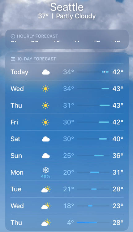
For anyone looking for a quick glance at the weather forecast, smartphone weather apps have become an indispensable tool. The default iPhone weather app has historically been a reliable source of quick and accurate weather forecasts, so I was shocked when this morning I saw a forecast low of 4°F for Seattle next Thursday.
For context, Sea-Tac airport hasn’t dropped into the single digits in December since 1968. In the last 50 years, February 4, 1989 is the only day to drop below 10°F. In this century it has yet to drop below 14°F.
The conditions needed for the temperature to drop below 15°F in Seattle are extremely rare. The ideal scenario is a fresh snowpack followed by a calm, clear night under high pressure. Lower-elevation spots in rural areas like Olympia airport have an easier time getting cold than Sea-Tac airport, which is on an elevated plateau. Only perfect conditions will suffice. The combination of global climate change and the growth of buildings, roads, and highways around Sea-Tac airport have added to the difficulty. In my opinion, getting all the way down to 4°F is virtually impossible in the current climate.
Where did this forecast come from?
After purchasing the weather company DarkSky in March 2020, Apple appears to have replaced the Weather Channel forecasts with some form of the weather model that was previously on the DarkSky app. I found a low of 3°F for my location on the DarkSky website at the same time my iPhone showed 4°F.
More reliable sources, such as the weather.com and the National Weather Service had much more reasonable forecast lows in the 20s for next Thursday. All of these sources use machine learning or other statistical postprocessing techniques to correct biases in the output from our numerical weather prediction (NWP) models such as the GFS and ECMWF.
National Weather Service forecasts rely heavily on the National Blend of Models (NBM), which gives statistical weighting to the most reliable models in recent weeks. The NBM forecast for KSEA this morning looked like this:

Ensemble means are also fairly good at providing accurate high/low temperature forecasts, although they are more prone to biases than the postprocessed forecasts. The ECMWF ensemble mean forecasts look similar to the NBM.

Chilly, but nowhere near those crazy iPhone numbers. So where did they come from?
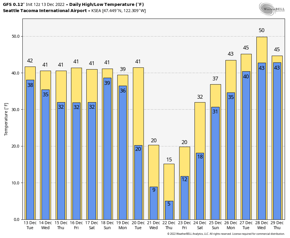
It turns out there were several deterministic models predicting extreme cold this morning. The high-resolution ECMWF model predicted a low of 8°F at Sea-Tac.

The deterministic GFS, which is notorious for overdoing arctic air intrusions in Puget Sound, was even colder with a low of 5°F.
The terrible forecasts from the GFS never make the iPhone app, but perhaps having several deterministic models simultaneously predicting cold weather was enough to make it to the app.
By the evening, the iPhone had corrected to the upper teens, but was still on the colder end of what might be expected.

Didn’t we say the same thing before it hit 110 degrees in June 2021?
It turns out that predicting arctic air is an entirely different challenge from predicting heat waves, especially in a region of complex terrain such as the PNW.
The main reason has to do with the nature of hot vs. cold air masses and how the vertical structure of the atmospheric is resolved by weather models. Hot air masses in summer are “well-mixed” through a considerable depth because the sun heats the earth’s surface and creates vertical convection and winds. The temperature relationship with height (known as the “dry adiabatic lapse rate”) is almost exactly 9.8 °C per km in a well-mixed layer. So if you know the temperature at a standard level like 850 hPa, you can easily solve for the surface temperature.
Cold air masses in winter are completely different. They are dense and resist vertical mixing. The lack of solar insulation in winter further prevents warming and mixing near the surface. Often the coldest air near the surface is capped with an inversion, especially at night. So the temperature as low as 100 meters above the surface is often poorly correlated with the surface temperature. This causes issues for the parameterizations that are used to generate 2-meter temperature forecasts in weather models.
The 2-meter forecasts have been getting better, but a smart statistical model or an experienced forecaster are the only ways to come up with decent overnight temperature forecasts on cold winter nights.
So how cold will it actually get in the Seattle area next week?
As of Tuesday night 12/13, there’s still too much uncertainty to say for sure. Taking an average of all of the models and ensembles would suggest lows bottoming out in the 20s in the city of Seattle and colder in outlying areas. Colder scenarios with lows in the teens in Seattle remain possible, especially if there is fresh snow on the ground.
The tremendous spread in possibilities can be seen in the ECMWF ensemble 2-meter temperature forecasts.
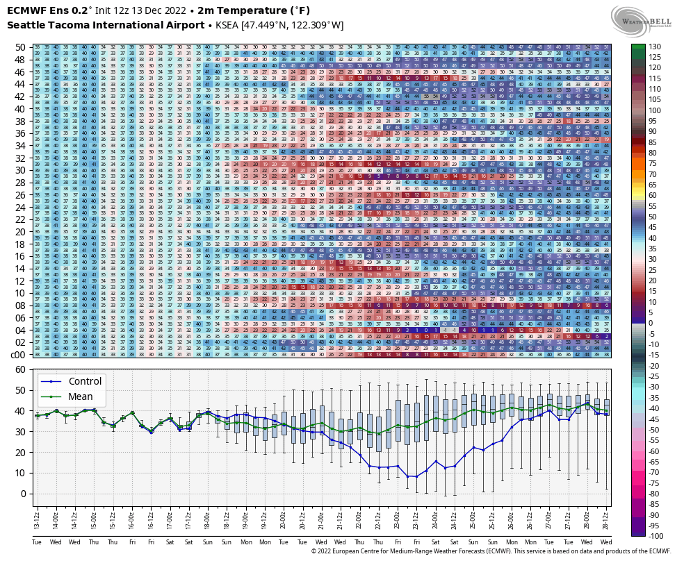
The safe bet is that temperatures will resemble the green ‘ensemble mean’ line in the lower panel above. But I guess you never know, maybe next week the ‘goldilocks’ conditions will come together and Seattle will get an arctic outbreak with a decent snowfall, followed by a calm, clear night…

I saw the forecast on my wife’s iPhone. It made no sense, especially since all the other forecasts are more in line with what you state. Now I understand why this app could be such an outlier. I’ve live in the Seattle area for 7 decades. Temperatures below 10 degrees are truly extreme.
LikeLike
We’ll see what comes of the model projections. But here in Bellingham, I continue to note the low amount of precipitation in the last year, at least at our standard reference point, the airport. So far, December has had only .2″ of precipitation. While our wettest month, November, was 80% of normal, that was due to significant rain on only 3 days. A high percentage of the days in November had no measurable rain. On a longer term basis, we are 8″ below normal for calendar year 2022 and 4″ below normal for the current water. For the 2021-22 water year, we were slightly above normal, but that was solely a result of 5 days in November 2021 that brought 11′ of rain and disastrous floods to Whatcom County. I appreciate that the weather has an inherent lumpiness to it, but we seem to be in a pattern of big extremes.
LikeLike
We just got our largest single snow event since we moved to Bellingham 6 years ago. We are about a mile south of the Bellingham Airport. I am a NWS citizen reporting station (see link on my name). I estimate snow depths of 8″ to 12″, with an average of 10″. There was not much snow drifting at our location as winds have been moderate here. The NWS forecast and winter storm warning was pretty accurate for this event and location. Waiting to see how long the cold air lasts and whether we get another dose of snow later in the week before the warm-up. The dreaded freezing rain is always the worry in the transitions.
LikeLike
I think that was a glitch cause I think they meant to put 14 degrees Fahrenheit and not 4 degrees Fahrenheit.
LikeLike