

Following the extreme heat wave in late June, it appeared that the PNW was in for a long and hot summer. As the map of high temperature departure from average shows below, that forecast has verified for the interior PNW. The coastal PNW west of the Cascades has avoided the worst of the summer heat.
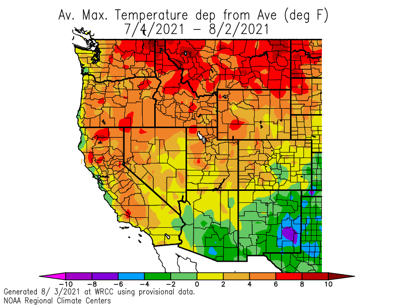
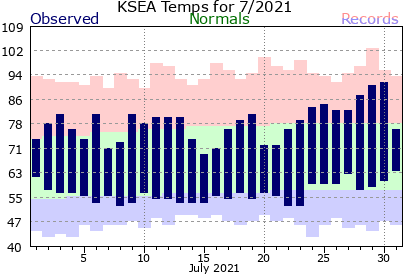
Seattle (Sea-Tac) ended July 0.8°F above normal thanks to a few warm days at the end of the month.
In contrast, Spokane experienced 15 straight days above normal to begin July and finished the month 6.5°F above normal.

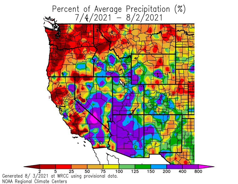
To go along with the heat, precipitation has been well below normal across the PNW and northern Rockies. Seattle and Portland both recorded zero precipitation in July with minimal precipitation across the rest of Washington State. A stronger-than-normal monsoon season has brought much-needed rainfall to the Southwest US.
Not surprisingly, wildfire activity is strongly correlated with the driest areas. The map below, a capture of fire.airnow.gov on August 3, shows numerous fires in the interior PNW pushing smoke (gray shades) with reduced air quality (gray shades) across a large portion of the central US.
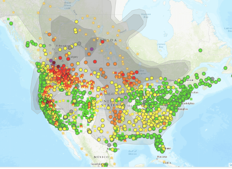
Numerous fires are also ongoing in southeast British Columbia.

Coastal portions of the PNW have benefitted from a favorable upper-level jet stream in July, which generally consisted of a ridge over the west-central US and a trough over the NE Pacific.

In the northwest, this jet stream pattern has resulted in more southwesterly flow aloft than we usually experience in mid-summer, which has pushed the smoke to our northeast and over the ridge into the upper-Midwest where smoke has been at unprecedented levels in Minnesota.
Forecast for the rest of August
The ongoing dry streak will come to an end shortly as a weak frontal system moves in from the Pacific this weekend. Rainfall amounts for Seattle are expected to be unimpressive, a couple tenths of an inch at best, but the mountains will likely see a more appreciable rainfall.

The latest European ensemble shows a >90% chance of 0.5″ of rain or more in the central and northern Cascades, as well as a greater than 50% chance of 0.5″+ of rain in the usual convergence zone area north of Seattle. Rain chances are also quite high in British Columbia which is great news for the wildfire situation to our north.
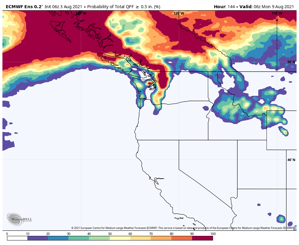
Unfortunately, little to no rain will fall in southern Oregon or northern California.
The next significant feature is expected to be an anomalous ridge over the NE Pacific during the second week of August.

This ridge will likely cut off our supply of onshore flow and allow a thicker plume of wildfire smoke to reach western WA/OR in the August 9-10 timeframe. A period of warmer temperatures is also likely around this time, although the wildfire smoke may suppress high temperatures to an extent.

One bit of good news is that current model projections suggest that the ridge will be a transient feature and we will return to an onshore flow regime by mid-August. However, there is not much agreement on whether there will be additional precipitation or if the regime change will simply clear the smoke away.
Recent history also suggests that the wildfire threat will continue until more significant and widespread fall precipitation (hopefully) arrives in mid-to-late September.

Thanks for your post! Always appreciate the clear way to present the science behind our weather with some more complex visuals for those who like to delve deeper into the data. You’re definitely my preferred PWN weather blog!
LikeLike
Thanks Reed, much appreciated!
LikeLike