

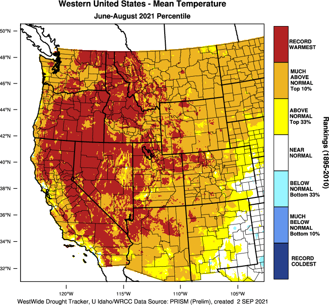
As we close the books on the 2021 meteorological summer (June 1 – August 31), it is of little surprise that 2021 was once again warmer and drier than normal across most of the PNW.
Average temperature was the warmest on record across much of the interior PNW and in the top 10% just about everywhere else.
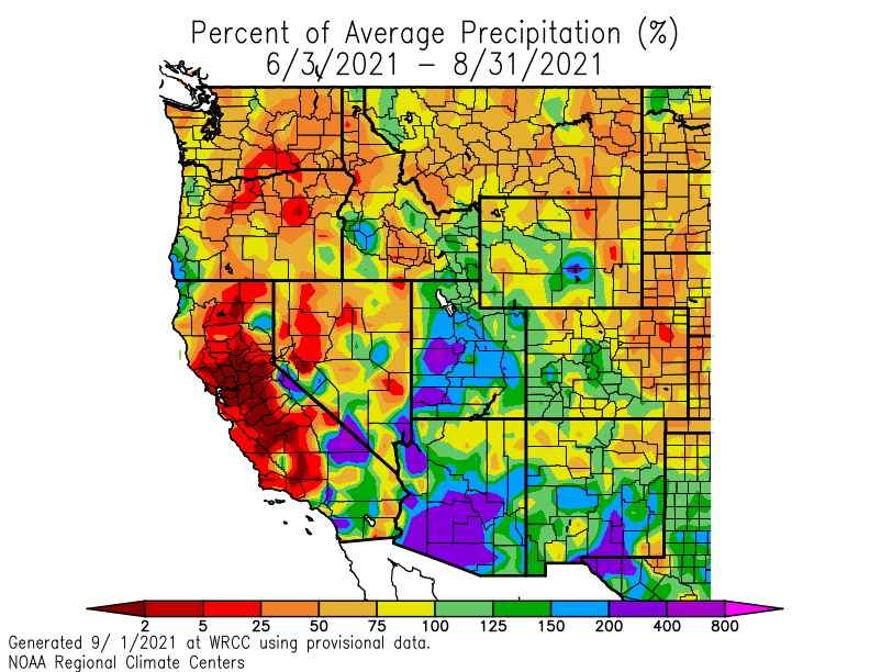
Precipitation was below normal in most of the PNW. One positive note was a stronger than normal monsoon in the desert Southwest.
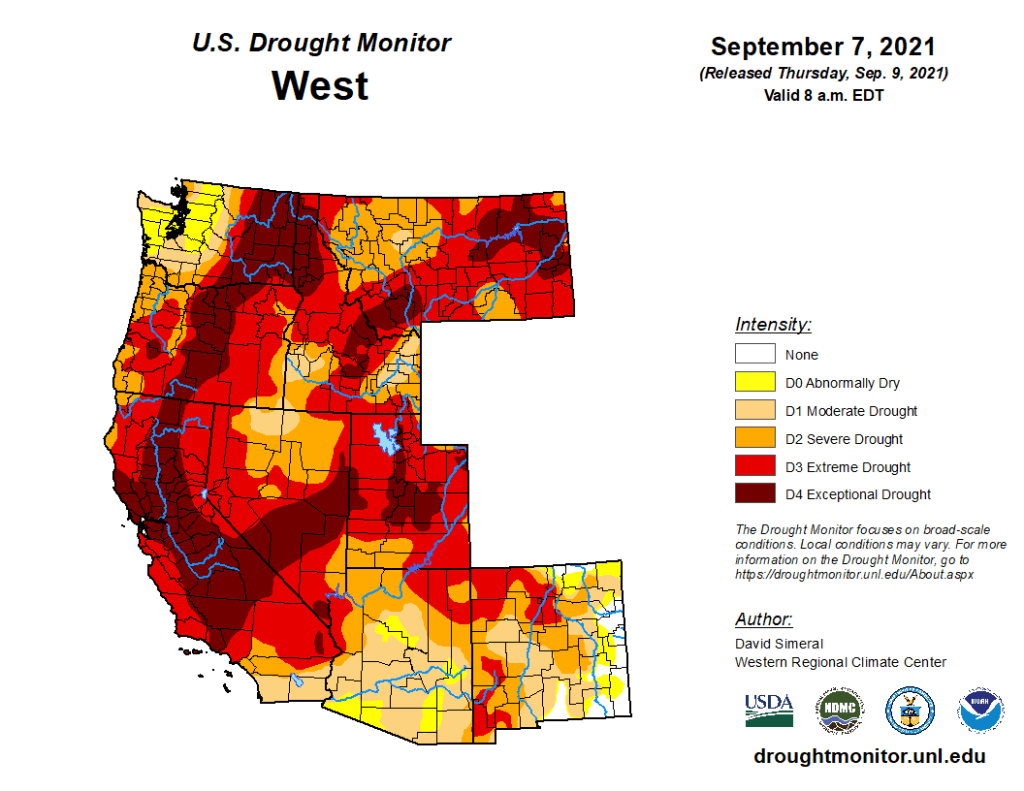
Not surprisingly, the drought situation as whole continues to worsen. In the PNW, the worst drought conditions (exceptional drought) are east of the Cascades.
In the United States as a whole, summer 2021 will be remembered for breaking the longstanding Dust Bowl temperature record from 1936.
Part of a long-term warming trend
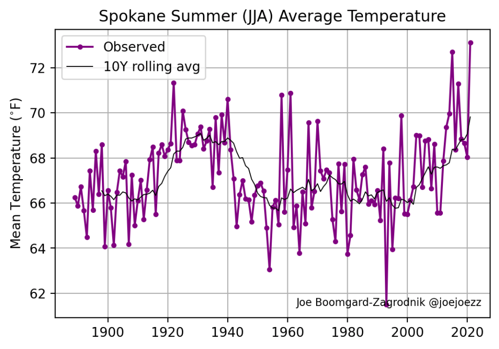
Looking at site-specific records, summer 2021 will go in the record books as the warmest or second-warmest on record at a number of PNW locations including Portland, Hoquiam, Yakima, and Spokane. Seattle finished in 4th place behind 2015, 2013, and 2018.

Most of the stations that recorded the warmest summer on record did so by beating 2015, which previously the warmest summer on record in the PNW by far. Out of the 28 PNW stations with long-term records in the map above, 22 set their warmest summer record in 2015 or 2021.
The effects of human-caused climate change are increasingly showing up in temperature and precipitation timeseries data. In Seattle, the last 9 summers have all seen average temperatures well above the historical mean.

Amazingly, the 7 warmest summers in the 128-year Seattle record have occurred in the past 10 years.
The trend is consistent across most locations in the PNW. In Portland (PDX), the summer of 2015 was more than 2°F above the previous all-time record. Just six years later, that unprecedented summer was nearly matched.

Summers in the 1920s-1930s were known for being exceptionally warm in locations east of the Cascades such as Spokane. With 2021 in the books, the 10-year rolling average at Spokane is now warmer than any 10-year stretch in the historical record.
Summers of the last several decades are not only trending warmer, they are trending drier as well. Seattle’s summer precipitation has been trending downward since the 1980s.

When it comes to drought, the key issue is the warming temperatures, which cause more evaporation and rapid soil drying. Dry season is dry even in ‘wet’ years, but the combination of much warmer + slightly drier is especially problematic.
In terms of impacts, the winter wheat crop in eastern Washington was hit especially hard by the drought. There has been no significant rainfall in southeastern Washington since February.
PNW wildfire season peaked early
Many feared the worst for wildfire season after a breakout of fires following the June 2021 heatwave. A series of fires in the North Cascades near Winthrop have arguably been the most problematic in Washington State, causing property damage, a loss of tourism revenue, and degraded air quality over a prolonged period.
A summary of the daily PM2.5 AQI from Winthrop shows a prolonged period of dangerous air quality from mid-July into August with improvement in recent weeks.
The Schneider Springs fire to the west of Yakima has also resulted in degraded air quality across portions of south-central Washington for the past month.
There are a few bits of good news, however. First, the prevalence of westerly flow in July and August has largely kept the unhealthy surface wildfire smoke away from western Washington, with the exception of one day, August 14. More importantly, a repeat of the mid-September wildfires of 2020 will not occur.
Why the improvement over 2020? Much of the variability in wildfire extent comes down to luck. The weather conditions that caused the September 2020 fires were highly unusual and a repeat did not occur.
Looking ahead to rainy season
Unlike the central and eastern US, where a large ridge will keep summer-like temperatures in place for a few more weeks, the Pacific Northwest is beginning an abrupt transition to cooler and rainy weather. NOAA’s latest 8-14 day outlooks show cool and wet weather on the way for the end of September.
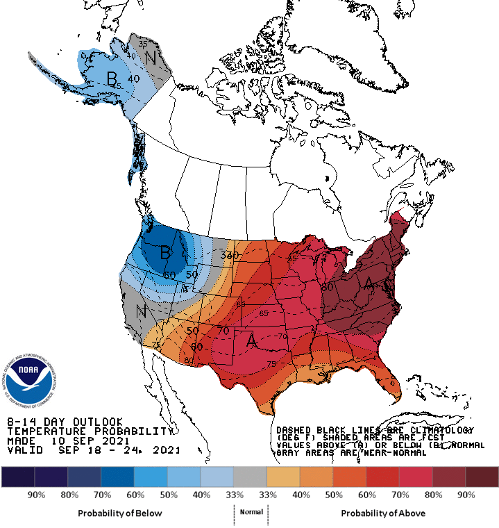
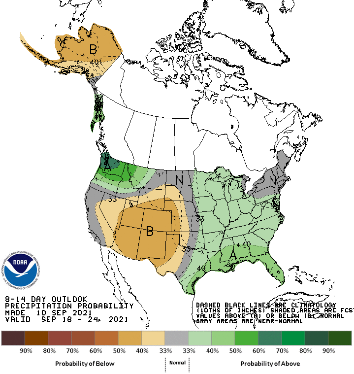
While there are a few chances for light rain in the next week, the real transition will occur in the September 17-18 time period. A strong frontal system is expected to bring a soaking rain to much of the PNW.

It’s hard to say what the rest of autumn will bring, but it will be a welcome relief to at least get one soaking rain to knock down the threat of new wildfires.

Thanks for the update, always appreciate your posts. Looking forward to a soaking rain – hopefully the models will turn out correct – and some cold weather to put an end to this long, hot and dry summer. Everything feels so parched right now.
LikeLiked by 1 person
A very good discussion. As you say in bold:
“Out of the 28 PNW stations with long-term records in the map above, 22 set their warmest summer record in 2015 or 2021.”
What is deeply concerning is these continuing record breakers do not appear to be the occasional random high temperature that breaks a 50 or 100 year old record. Instead, it is a continuing pattern of record breaking of recently set records. The wheat growers in the eastern part of the state are having a very tough time. While we appear somewhat fortunate as far as fires go on the western side of the state, continuing years of hot and dry weather in the forest will also set us up for bad fires on the west side and we could have events similar to California and Oregon. It is not enough to simply blame all of this on forest mismanagement by launching an attack on government officials as incompetent (and you have not done that). If we were inclined to blame wild fires on mismanagement, we should also be inclined to blame the human species for the mismanagement of the planet.
LikeLiked by 1 person