

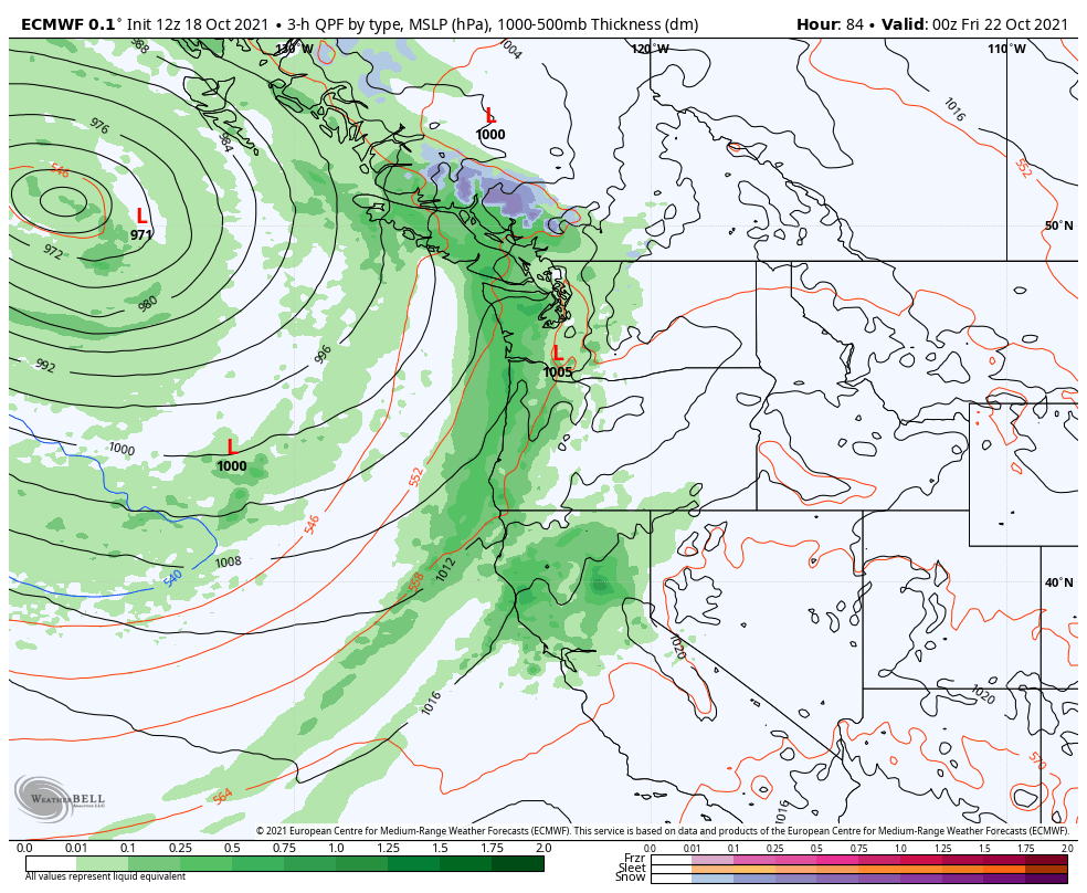
Peak storm season is ramping up over the PNW and the opportunities for significant rain and wind will be numerous from now through the end of October. The first storm in this series brought significant rainfall to British Columbia over the weekend while most of interior WA/OR enjoyed mild conditions in the warm sector prior to the passage of a weak cold front on Sunday afternoon/evening. Conditions will remain mild for a few more days before the action picks up again on Thursday.
In fact, as of Monday morning, the pieces are already coming together to deliver a spectacular storm to the northeast Pacific. Let’s go over the fascinating details.
Tropical Storm Namtheun
More often than not, extreme weather events in the mid-latitudes are at least partially triggered by events in the tropics. In this case, a relatively benign tropical storm in the open waters of the west Pacific is helping supercharge what was already an impressive jet stream.
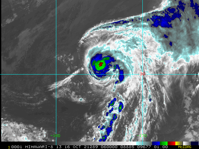
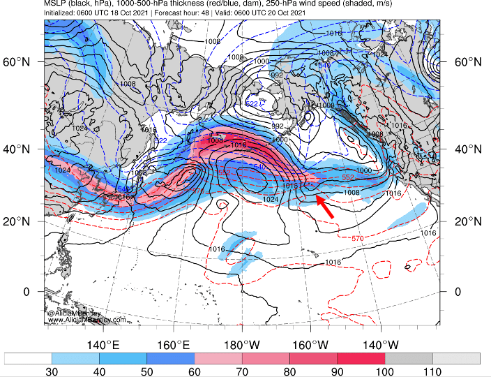
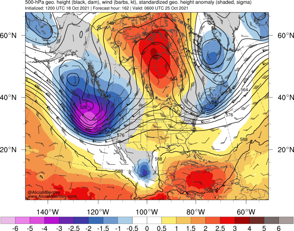
Pictured above at its (unimpressive) peak two days ago, tropical storm Namtheun is currently undergoing extratropical transition. One can watch this process unfold using the fantastic jet stream + sea level pressure maps by Alicia M Bentley.
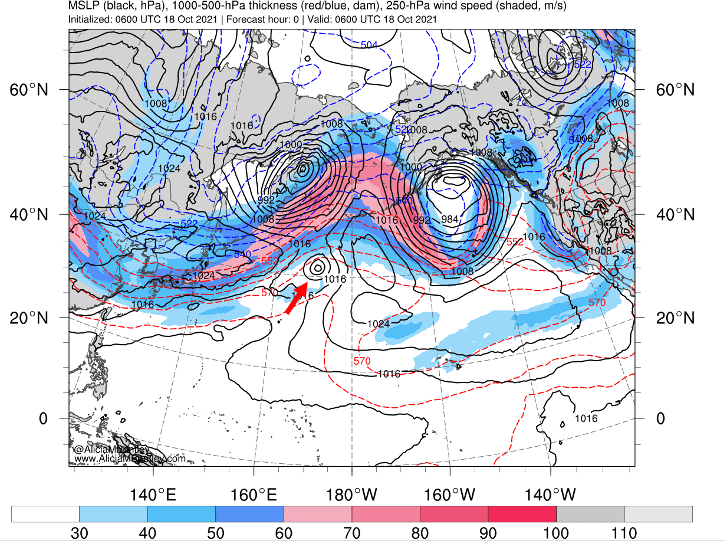
The red arrow points to the small pressure minimum associated with the remnants of the tropical storm. Even the strongest tropical cyclones are tiny little weather systems compared with the massive, 1000s-of-km scale of the mid-latitude jet stream and the two larger extratropical storms on either end of the North Pacific.
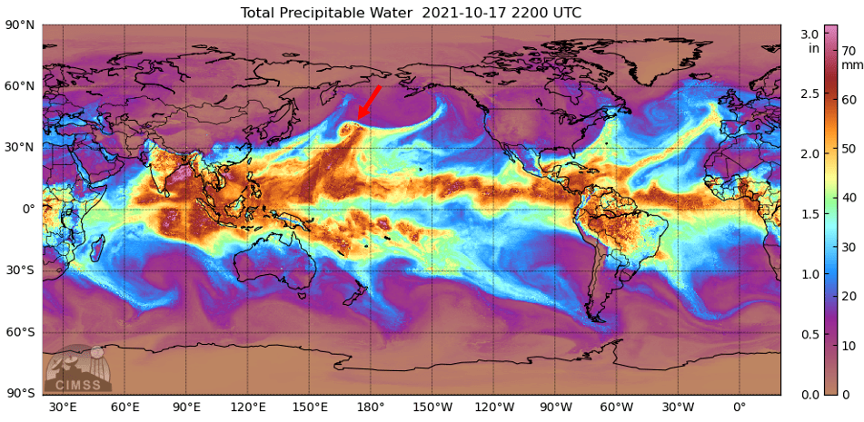
However, what tropical cyclones lack in size they make up for in moisture. A precipitable water satellite image from Sunday shows a pronounced mass of high moisture content associated with tropical storm, most of which will be fed directly into the mid-latitude storm track.
Let’s watch this process unfold.
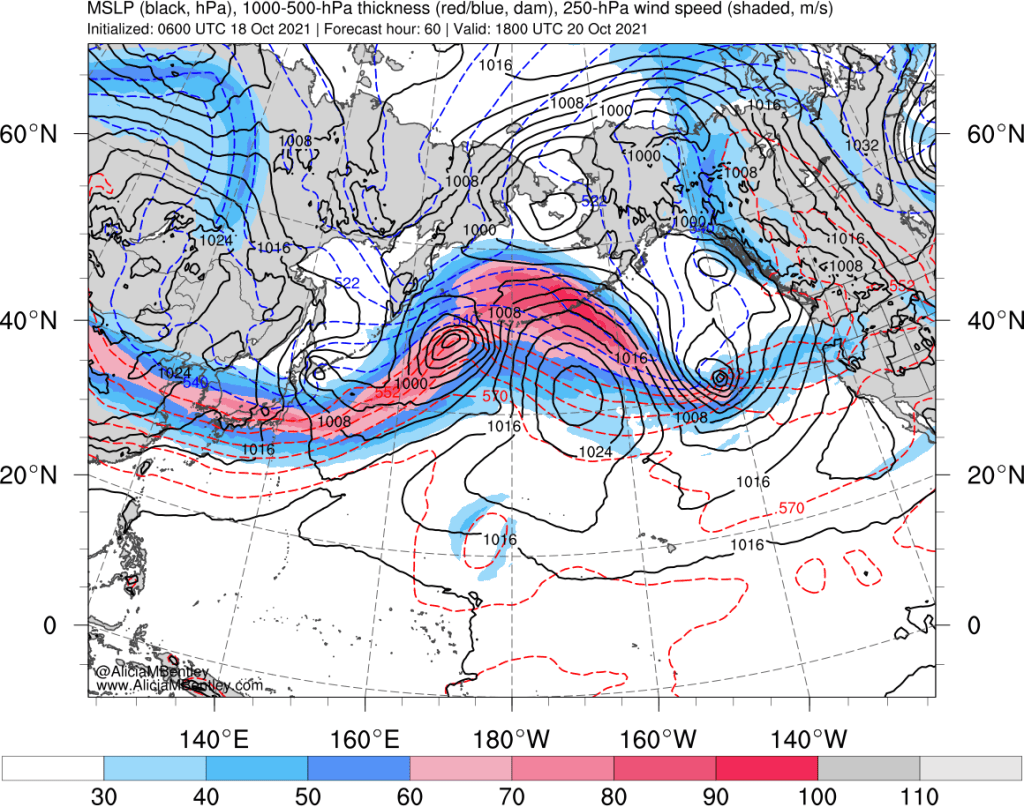
Moving ahead to Monday evening, our ex-tropical storm has lost some of its definition in the surface pressure contours, but the pink stripe associated with the jet stream will be in direct proximity to the remains of the storm, and more importantly, the energy associated with its tropical moisture.
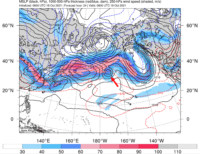
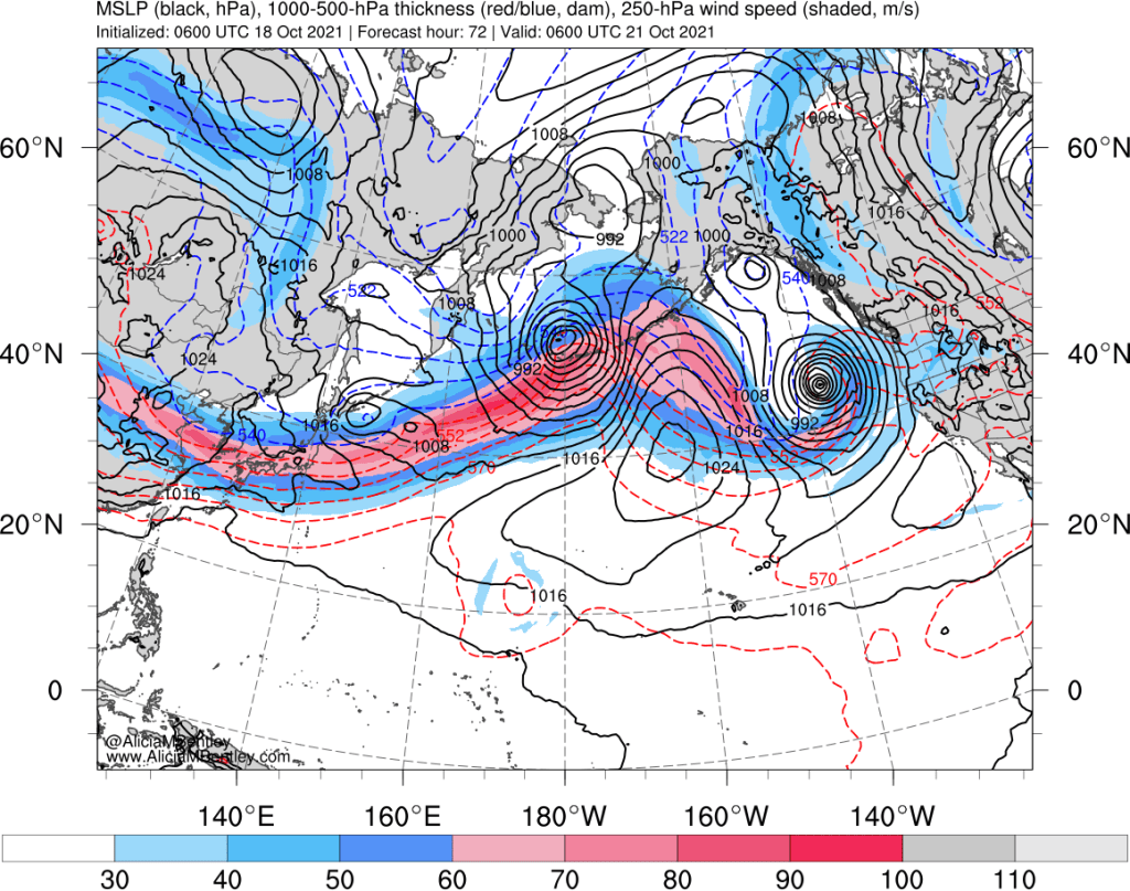
Tuesday evening, 24 hours later, our former tropical cyclone is now just a wave in the jet stream. But behind the scenes, something more ominous is about to occur. Our little wave is on the cusp of rapidly intensifying into a powerful extratropical cyclone.
We need to bring in a couple more weather maps to get an idea of why this rapid intensification, or bombogenesis, is expected to occur. Some of this terminology may be unfamiliar to readers of this blog, but I will attempt to explain.
The map below shows a quantity called potential vorticity, PV for short. The orange/reddish area associated with our wave of interest is called an upper-level PV anomaly. To meteorologists, the PV anomaly indicates the presence of an upper-level disturbance with the potential to amplify into a strong cyclone under the right conditions.
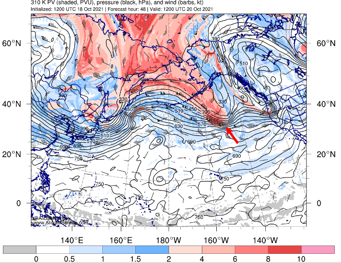
Upper-level PV anomalies are fairly ubiquitous in the atmospheric, but the favorable element in this case is the juxtaposition of the warm/moist anomaly associated with our former tropical cyclone.
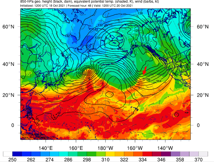
The orange/red area indicated by the arrow above can be thought of as a low level PV anomaly. Similar to the upper-level anomaly, it has the potential to amplify under the right conditions as a result of the inherently unstable nature of a warm anomaly in proximity to the colder air to the north. And, to reiterate, the former tropical storm is the reason this anomaly is here. Without the tropical element, we would not be dealing with such an impressive bomb cyclone.
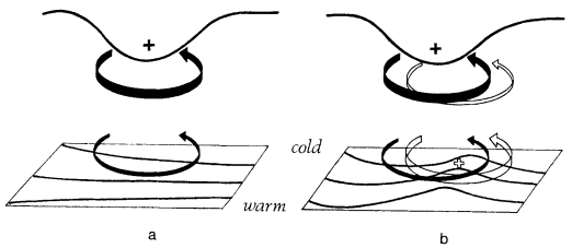
It turns out that when an upper- and lower-level PV anomaly interact, the tendency of both anomalies to generate cyclonic rotation can rapidly spin up a low pressure system. This framework was described in a famous meteorology paper, Hoskins et al. (1985). The right side of the figure (below) from that paper shows the positive feedback process between the upper and lower PV anomalies.
How does this process look in the real world? By Wednesday afternoon, a closed cyclone (black pressure contours in the image below) is expected to form exactly where we would have expected from Tuesday evening’s weather maps.
Once the positive feedback process gets going, the result is phenomenal. Just 12 hours later, a deep cyclone with minimum pressure around 960 hPa will be off the coast of Washington/Oregon.
It almost looks like it appeared out of nowhere! Fortunately, we have the ability to both understand and track the underlying meteorology, leading to high-confidence predictions of where the cyclone will end up.
Forecast confidence is high
A cyclone of this intensity can cause tremendous damage if it ventures too close to the PNW coast. Looking at model ensemble predictions of the low center, we can see that a close encounter is highly unlikely.
The ECMWF and GFS ensemble low positions are all at least 500 miles off the coast of Washington when the storm is expected to be near peak intensity on Thursday.
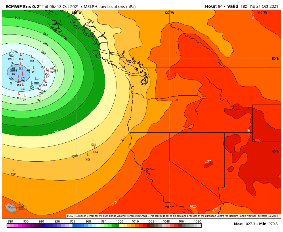
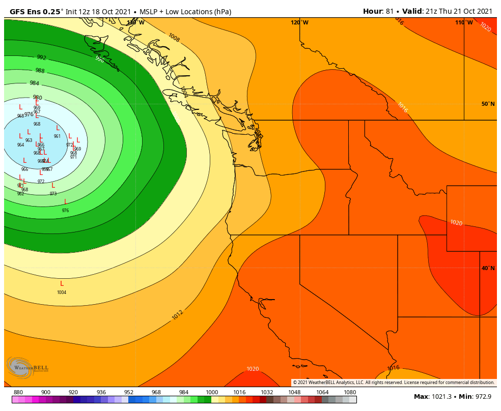
From there, the low will weaken as it moves northward toward Haida Gwaii.
The expansive frontal band associated with the cyclone will make it to the coast on Thursday, but the impacts for most will be similar to a normal weather system. Elevated winds and surf are possible in coastal areas.
More storms on the way
Models continue to show a deep trough offshore early next week, so continued rainfall along with the potential for additional low pressure systems to make a closer approach to the coast. Stay tuned.

Is this a weather pattern similar to that which resulted in Typhoon Freda in October of 1962?
LikeLike
Yes! We’re lucky this one is staying offshore.
LikeLike
Thank you for the detailed and informative discussion of the past and anticipated future evolution and mechanics of this vigorous storm. I also appreciate your clarity in stating “a close encounter [with the Pacific Northwest] is highly unlikely.” There have been some online posts that were, to put it charitably, ambiguous at best about whether inland Washington residents needed to worry about a major event. However, so I am not misunderstood, the NWS has been very clear for some time that this storm is not forecast to cause significant issues with us. I think all of this points out the mischief that can occur with careless use of language in discussing upcoming weather events.
LikeLike