

Friday morning’s satellite image was a sight to behold, as a large mid-latitude cyclone extended its reach across thousands of square miles of the NE Pacific.
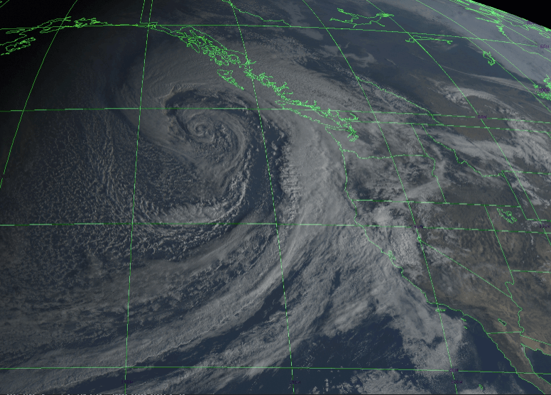
Despite the impressive visuals, impacts from the storm on land were relatively minor for the most part. The same can’t be said for the open waters, as the US Coast Guard reported that approximately 40 shipping containers were dislodged from a container ship located 43 miles west of the entrance to the Strait of Juan de Fuca.
Amazingly, another cyclone will undergo a similar rapid deepening on Sunday and make another close approach to the PNW.
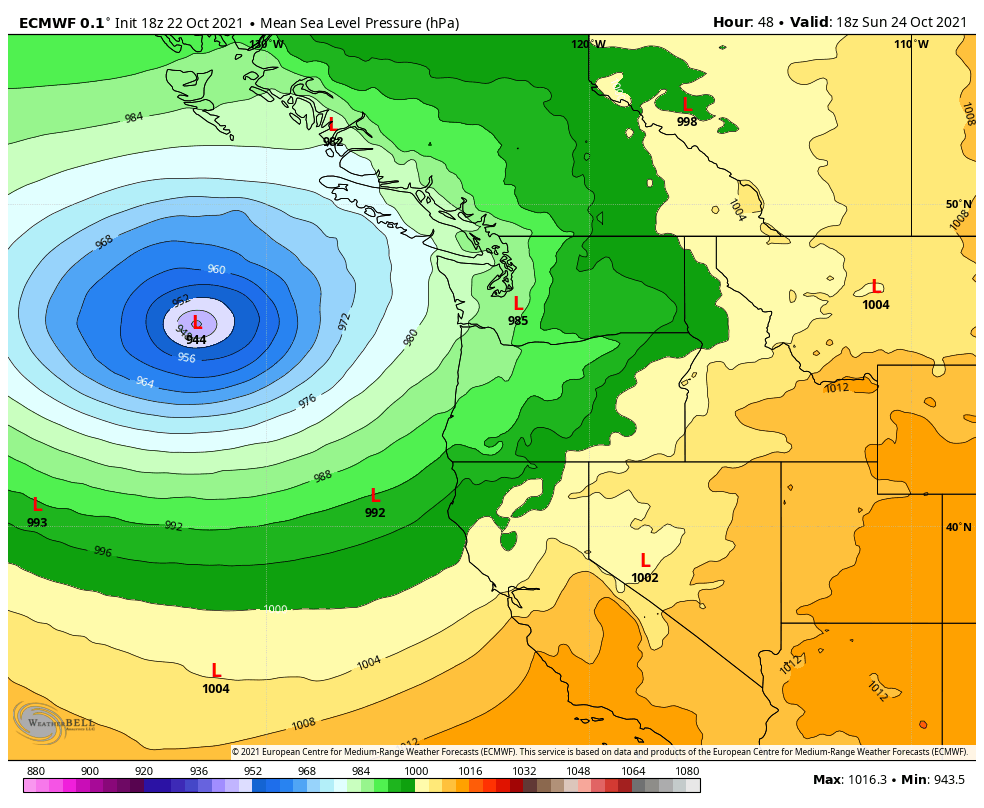
Let’s start by examining the evolution on the large scale using maps of the jet stream (250 hPa wind) and sea-level pressure. The origin of this cyclone is a wave along a robust, zonal (west-east orientated) jet stream. As of Saturday morning it will be around 155°W.

Just 24 hours later, Sunday morning, this wave will amplify into another impressive area of low pressure.
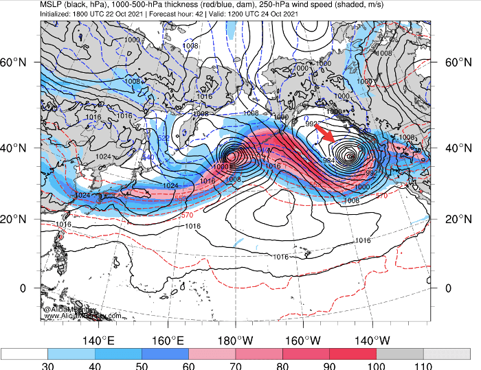
The coupled evolution of the jet stream and cyclone is best visualized in an animation.
How strong will the cyclone get?
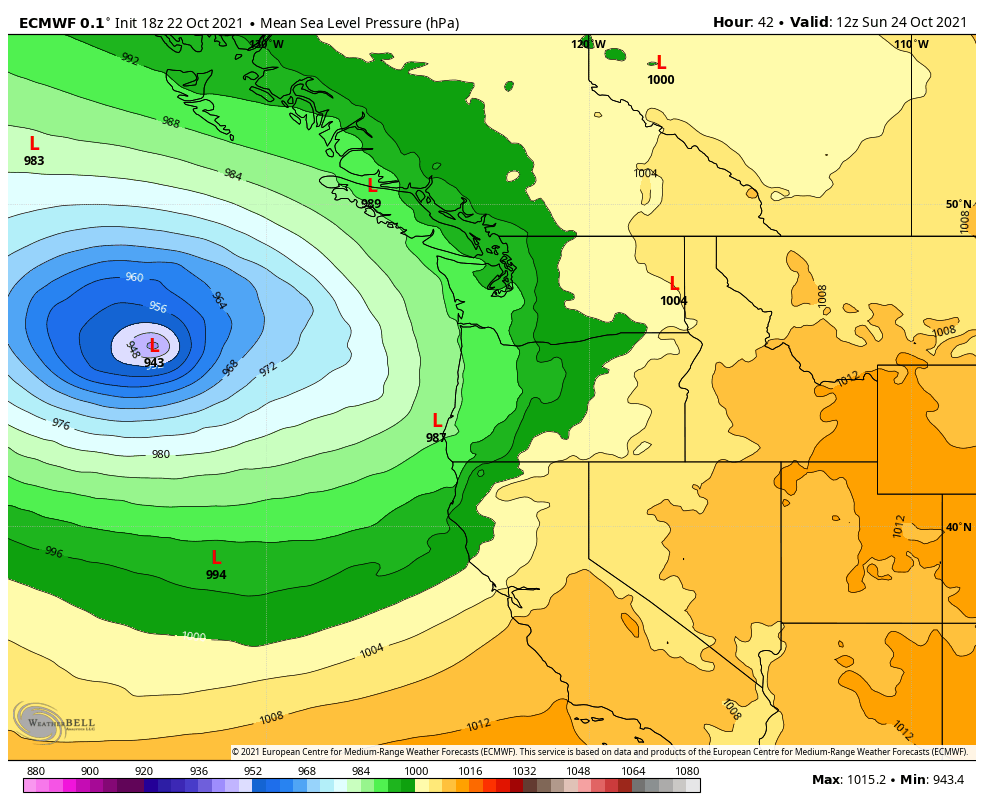
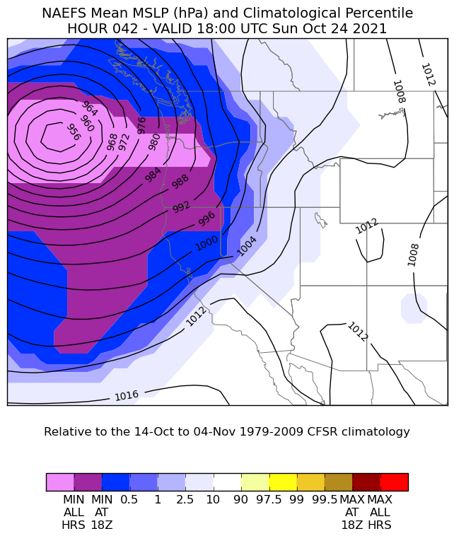
Model forecasts of sea-level pressure are even lower than the first bomb cyclone on Friday. The latest deterministic ECMWF run predicts a 943 hPa center on Sunday morning. The GFS predicts 945 hPa.
The ECMWF ensemble members have reasonably high confidence in the intensity and position of the low at this time.
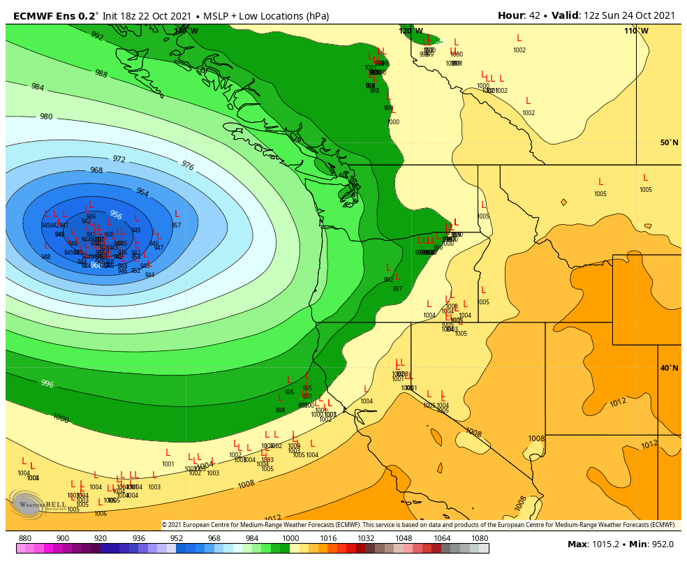
Same for the GFS.

Low pressure systems stronger than 960-970 hPa are unusual this close to our coastline at any time of year. This system is outside of the climatology for late October (1979-2009 is the reference period in the image below). For reference, the famous 1962 wind storm bottomed out at 955 hPa.
Fortunately, this storm will be too far away from the coast to cause devastating impacts on par with our famous windstorms. But there are still a number of impacts to discuss.
Several windy periods ahead
Strong winds are driven by gradients between high and low pressure centers. On Sunday, a strong pressure gradient will be directed east-to-west (perpendicular to the contours in the above maps). The result will be strong gap winds through the Cascade passes, a phenomenon that is known locally as Cascadia winds.
The winds will be especially impressive over the open ocean near the low pressure center, sustained in the 50-70 mph range.
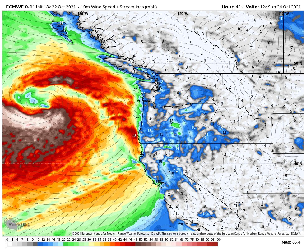
The long fetch of strong winds to the south of the low will generate an impressive surf. Wave heights will approach 10 m (30 ft) in the open ocean on Sunday evening.
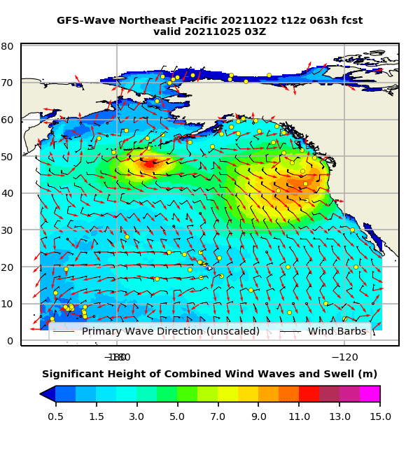
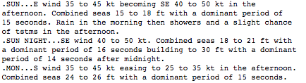
The strong wind and waves will reach the Washington coastline late on Sunday evening. The NWS is currently predicting sustained winds of 40 mph at the coast with gusts to 60 mph. NOAA’s forecast for the coastal waters shows seas up to 30 ft on Sunday night.
Lesser impacts around Puget Sound
Similar to Friday’s storm, impacts will be less severe around Puget Sound. It may seem surprising that such a powerful storm would fail to generate stronger winds near Seattle.
To understand why, take a look at the hourly ECMWF pressure forecasts from Sunday afternoon – early Tuesday morning. The combination of the cyclone’s slow forward motion and rapid weakening results in a relatively weak storm making landfall on the NW end of Vancouver Island.
Historically, storms taking this track toward Vancouver Island have sometimes generated strong winds in Puget Sound. In this case, the south-north pressure gradient through Puget Sound never gets strong enough to generate significant winds in the Seattle area. The San Juans, located closer to the low center, are more likely to experience stronger winds.
Most ECMWF ensemble members show peak wind gusts in the 35-45 mph range at Sea-Tac airport. Enough to cause some tree damage and isolated power outages.
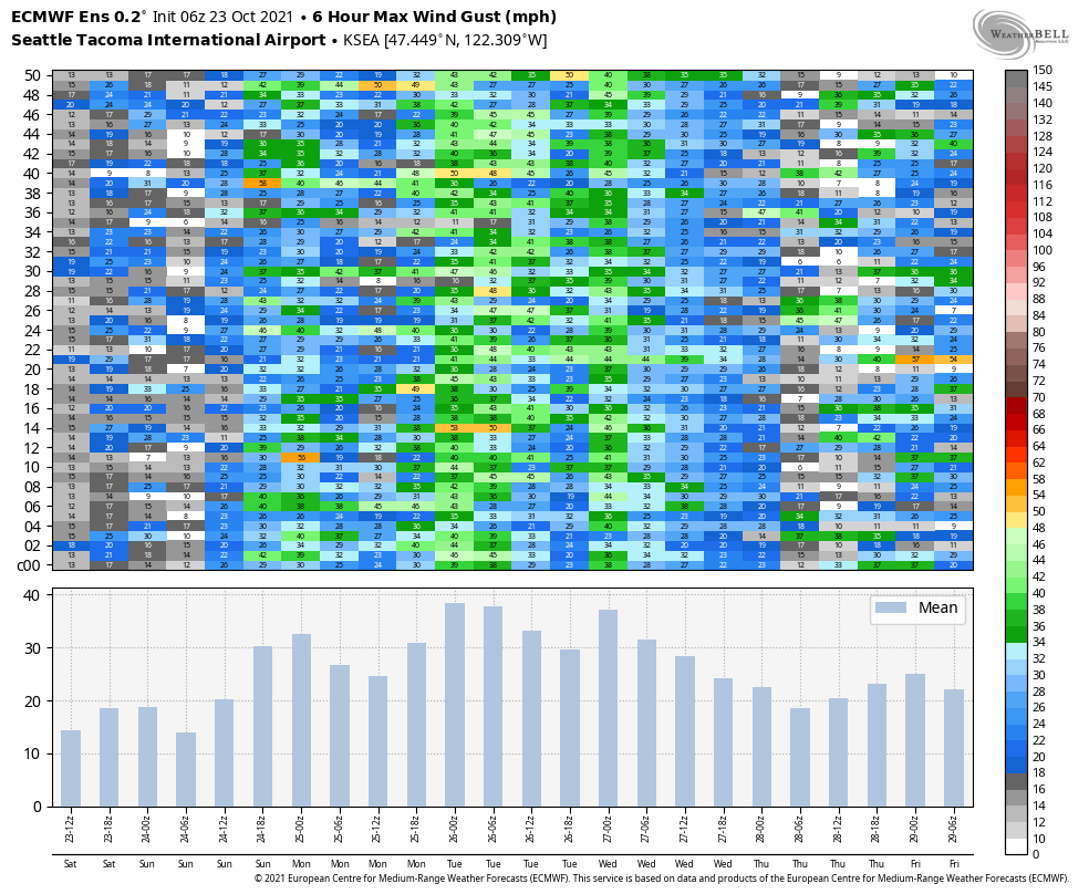
Note that several periods of strong winds are expected at Sea-Tac. The easterly gap winds will reach the airport on Sunday, followed by strong southerlies on Monday afternoon and evening. Finally, a frontal passage is expected to bring strong winds on Tuesday.
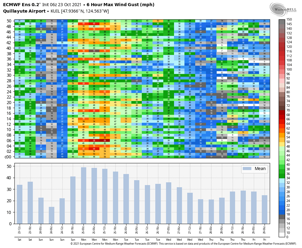
What about the coast? Wind gusts up to 50 mph are expected at Quillayute airport on the Olympic Peninsula, although a few ECMWF emsemble members show gusts above 60 mph. Quillayute airport is a few miles inland, so expect even stronger wind gusts directly at the coast.
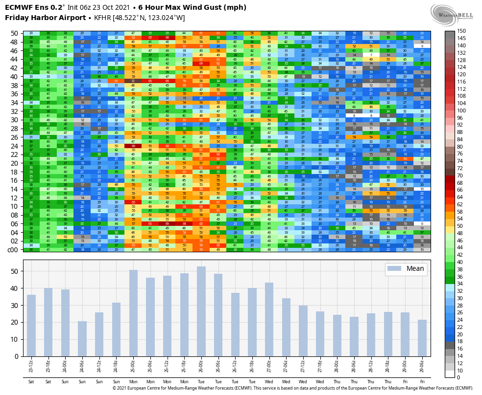
As noted above, the San Juans will also experience strong winds. The image below shows maximum gusts at Friday Harbor, which will be in the 40-50+ mph range for a 24+ hour period from late Sunday through Monday.
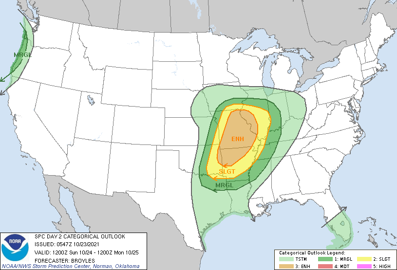
Thunderstorms at the coast on Sunday afternoon
The combination of instability from cold air aloft and low-level wind shear (i.e. changing wind directions with height) will bring a chance of organized thunderstorms to the coast around on Sunday afternoon. The Storm Prediction Center (SPC) is predicting a marginal risk of severe weather (primarily hail).
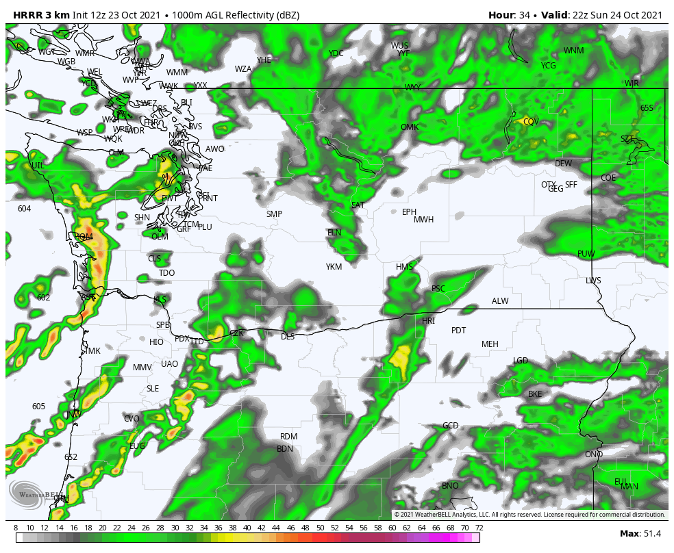
A simulated radar reflectivity forecast from the HRRR model on Sunday afternoon shows a few areas of convection. Notably, the convection appears to be organized into lines/bowing segments which happens as a result of the favorable wind shear. These will also be extremely fast-moving storms!
Even though it was not highlighted by the SPC, I wouldn’t be surprised to see a brief, weak tornado in one of these storms as well as strong wind gusts associated with heavy precipitation mixing stronger winds down the the surface.
Meteorological eye candy
Weather impacts tend to generate the biggest headlines, so fans of extreme weather in the Seattle area might be left feeling like the “bomb cyclones” are not living up to expectations.
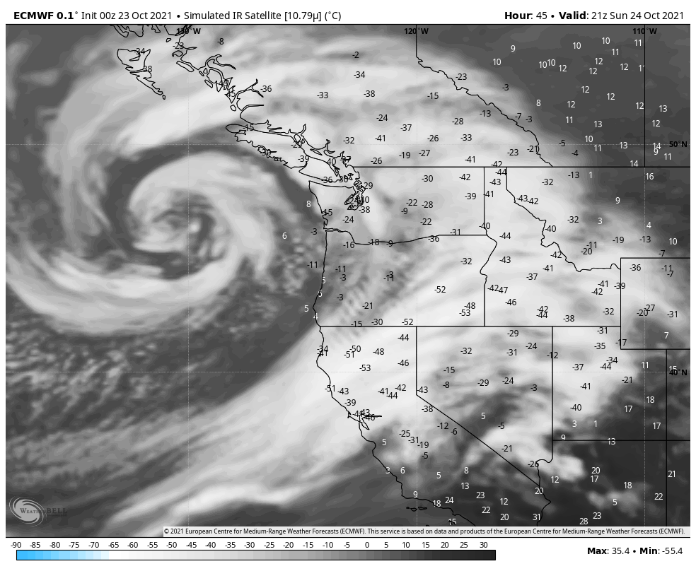
A storm of this size and scale is best appreciated looking down from space. The simulated infrared satellite image for Sunday afternoon shows what to expect — bands of clouds and rain spiraling outward for hundreds of miles from the low center in all directions. A sight to behold!
If that’s not enough, one can always plan an impromptu “vacation” to the coast on Sunday to see the storm in action.

I discovered this site a week ago and am very impressed. Many thanks. Just two questions:
1 Does the heading “Thunderstorms at the coast on Saturday” refer to the feature over Mississippi-Missouri of the chart below this heading?
2 Some of the charts do not explain what is plotted or the units.
I am upset by the loss of shipping containers. I believe container ships should not be in these storms if they have a choice. The shipping company knew this storm was coming and could have redirected this ship to avoid the storm and keep the crews and containers save. I believe they seldom do this because it leads to loss of profit. These containers ae now a hazard to other ships and their contents can wash up on shore.
Bill Crawford
billcraw@telus.net
LikeLike
An excellent description again.
This storm turned out to be quite modest here in Bellingham. One short peak gust of 53 mph at the airport and a sharp decline after that. We typically get a number of storms during the Fall-Winter season with gusts in the mid-fifties so this is not an all unusual for this time of year. I am guessing that the power outages down south were a result of the sudden easterlies around I-90 and other Cascade gaps, which faded fairly quickly. I am also guessing that power outages were mostly the result of deciduous trees with a lot of leaves losing some branches, although there were some locations with big trees coming down. A number of pictures I saw were the dreaded Alders with leaves, which are notorious. But I see power is getting quickly restored which indicates there was not major damage to the distribution systems. Most of this was probably the result of stray branches tripping a breaker on a pole. PSE currently has less than 4,000 customers affected and Seattle is down to only a couple of hundred. If there had been major damage, power would have been out for a lot longer.
We actually drove to North Seattle and the Monroe area on Sunday morning and returned by 2 pm. Winds were very modest with some easterly cross-winds in Mount Vernon and Everett, but quite manageable if you slowed down a bit.
LikeLike
As a followup, what is striking is the extent to which fairly modest winds are continuing to cause downed trees and electrical interruptions in the Central Puget Sound area. These are not major windstorms. Gusts are typically in the 30-40 mph range for very short periods and a bit more in exposed areas. I continue to notice from published pictures that many of these downed trees still have leaves. But what I am really wondering is how much of this is due to heat stressed trees coming down. It also appears likely that moisture saturation in the soils is contributing as well. We are getting far less of this in the Bellingham area, where this level of wind is very commonplace during the stormy season.
LikeLike