

On average, the last week in July is the warmest and driest week of the year over much of the PNW. In 2022, it is poised to bring the hottest temperatures to much of the region since the historic heat wave of June 2021.
Our global weather models, a true triumph of modern technology, have once again provided over a week of advance warning for the incoming heat wave. While we do not know the exact details and timing of the hottest weather, there is high confidence that maximum temperatures will exceed 90°F in the Seattle area and 95°F in Portland during the Tuesday-Thursday period next week (July 26-28). Additionally, the warm airmass is expected to linger through the end of July and possibly longer, with temperatures remaining above normal for an extended period of time.
If the warmer ensemble members are correct, Seattle could reach the upper-90s and Portland could exceed 100 at the peak of the heat wave next week.
Will this heat wave be as severe as the historic June 2021 heat wave?
Fortunately not. But it still has the potential to be dangerously warm.
The forecast 500 hPa height anomaly map for the middle of next week shows a large ridge along western North America with a large area of anomalous warmth.

As a reminder, here’s the same plot from the June 2021 heat wave. The terrifying size and symmetry of that ridge is not going to be matched by next week’s heat wave.

However, the colors in the above plots represent anomalies relative to the time of year. It takes less of an anomaly to get a strong heat wave in late July compared with late June.
Models do not agree on the severity and duration of the heat wave
While we can be highly confident that (1) there will be an impactful heat wave; and (2) it will not be as severe as June 2021, the models have not converged on a number of important details.
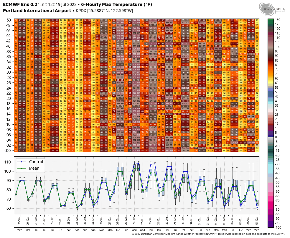
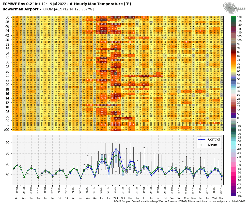
Let’s look at the ECMWF ensemble maximum temperatures for Seattle, Portland, and Hoquiam from the 12 UTC run on Tuesday 7/19.
The plot for Seattle shows high confidence of two days in the 90s next Tuesday and Wednesday and about a 50/50 chance of two additional days in the 90s on Thursday and Friday. About a quarter of ensemble members have the heat wave continuing into the weekend of the 30th-31st of July.

Portland looks to be really hot if the ECMWF forecasts are to be believed. Monday, Tuesday, and Wednesday all look to approach or exceed 100°F. Tuesday looks especially hot, with many ensemble members about 105°F.
Hoquiam, on the Pacific Coast, is a bit more interesting. The ensemble mean (green line in the lower panel) shows only two days of potential warmth (80s), next Monday and Tuesday. A number of ensemble members show temperatures staying in the 70s for the entire heat wave.
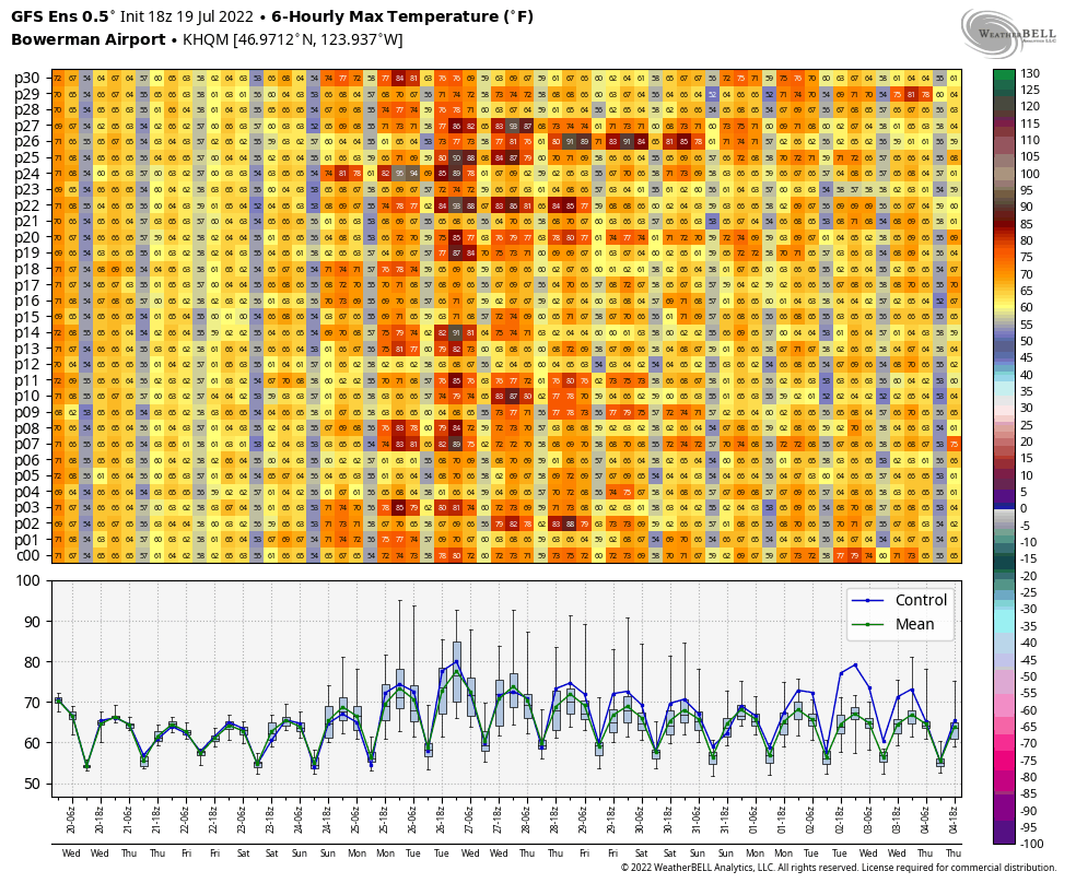
The GFS ensemble forecast (00 UTC 7/20) for Hoquiam shows even more uncertainty.
Why is there so much uncertainty at the coast?
The main uncertainty factor in PNW heat waves to the west of the Cascades is the strength and position of the “thermal trough” that is often coupled with strong ridges of high pressure in the warm season. This feature deserves a bit of explanation since it is a classic example of a weather phenomenon caused by interplay between large-scale weather patterns and our local topography.
The thermal trough is basically a narrow region of low pressure that forms to the west of the Cascades as a consequence of air descending and warming. The classic PNW heat wave begins when a large-scale ridge of high pressure forces air from higher terrain east of the Cascades into western WA/OR and the immediate coastal region.
Warmer air is less dense than cooler air, so the “thermal trough” appears as a region of anomalously low surface pressure on weather maps. In a positive feedback loop, the low pressure trough causes the easterlies to strengthen, further warming the airmass over Seattle and Portland by day 2-3 of a typical heat wave.
However, there also tends to be higher pressure over the cold waters of the north Pacific. As soon as the original ridge of high pressure that started the heat wave weakens or moves away, the pressure gradient rapidly reverses and a rapid westerly “marine push” overwhelms the warm air and ends the heat wave in a matter of minutes.
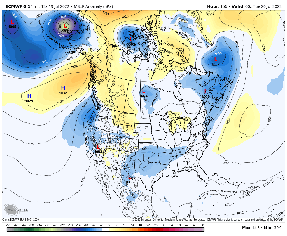
The ECMWF forecast pressure anomalies for Monday evening show the classic thermal trough signature along the WA/OR coast with high pressure to the east over the interior Rocky Mountains and farther west over the NE Pacific.
In contrast, the GFS has a weaker high pressure anomaly over Montana/Alberta and a much stronger high pressure anomaly over the NE Pacific. There is still a thermal trough signature but it isn’t as distinct as the ECMWF forecast.

Now we have an explanation for the difference in temperature forecasts at Hoquiam next week! If a stronger thermal trough forms like the ECMWF shows, Seattle/Portland will be hotter and the easterly winds are more likely to push the hot air all the way to the Pacific Coast. If the GFS is right, there will be enough of an onshore pressure gradient to keep Hoquiam in the 60s-70s and Seattle in lower-90s instead of the upper-90s.
Subtle differences in the upper-air forecast
The easiest way to diagnose the differences in the forecast is by going back to our 500 hPa anomaly maps. Scroll between the two images below (ECMWF and GFS forecasts for Monday evening) and note the position of the red blob.


If the ridge of high pressure ends up farther west like the GFS shows, it leads to a weaker thermal trough and consequently a less significant heat wave. Still hot, but not as bad as it could have been.
While the GFS doesn’t show much of a thermal trough, it also doesn’t show much of an end to the large-scale ridging over the NE Pacific. So the potential is there for high temperatures to remain in the upper-80s and low-90s west of the Cascades into August if forecasts trend in the direction of the GFS.
Nobody knows which model solution will end up being right, but it’s generally a bad idea to bet against the ECMWF ensemble, as well as the recent history of PNW heat waves ending up near the warmer end of the forecasts from 7-10 days out. So municipalities and individuals should prepare now for temperatures approaching 100°F in portions of the Seattle metro area and 105-110°F in the Portland area next week.

Thanks for breaking this down in a clear and coherent way. Looks like this will be an intense heat wave – not quite as bad as 2021, but almost.
LikeLike
Thank you for the detailed analysis! I enjoy reading your posts to break down our area weather.
LikeLike
It will be interesting to see if there is an underestimate of maximum temperatures this event. It is currently (~2:45pm) 82F in Bellingham, passing the NWS forecast high at 80F. The winds have shifted to the NE. Highest temperature will probably be around 5:30 pm, so I would not be surprised if we got into the upper 80’s. I recall a year ago when we set an all time high temperature of 99F on June 28 at the tail end of the big heat wave, the temperature soared within a very short period of time.
Michael Corn, N7DTY
https://www.weather.gov/wrh/timeseries?site=AV482
LikeLike