

Pleasant but chilly weather has been the story across the PNW this week as cold air remains entrenched across most of the western US. The latest 500 hPa anomaly map shows an active weather pattern across the US. The trough that was responsible or our cold and active weather has progressed eastward while another weak trough approaches the west coast of the US. Much of the eastern US looks more like September with unseasonably warm weather and a hurricane in Florida.

Next week, a massive, massive ridge is expected to build over Alaska and western Canada. Here’s the GFS forecast for next Wednesday the 16th.
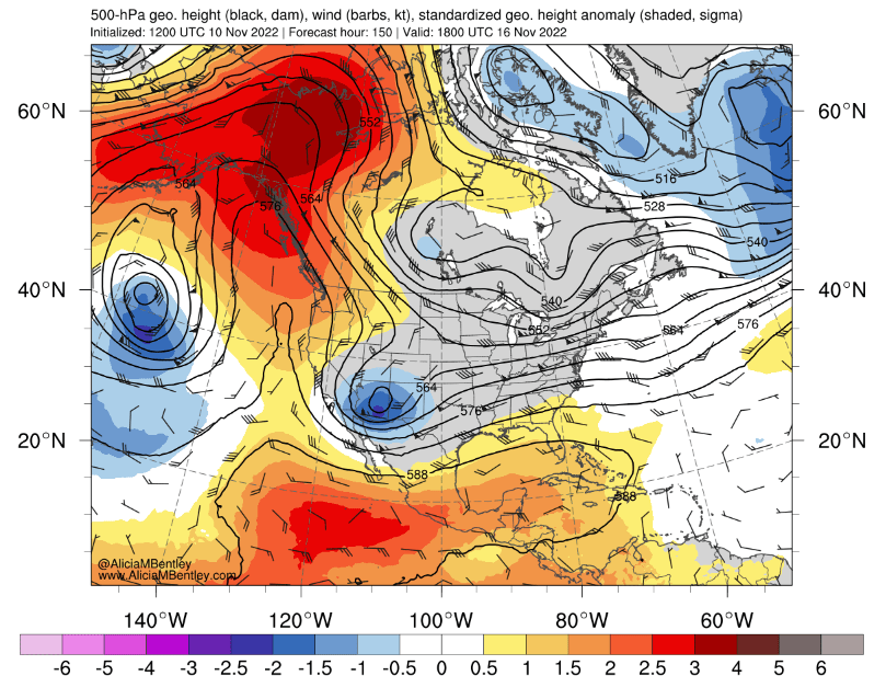
There are two main takeaways from this blocking pattern:
- Other than the weak system currently approaching the coast, the PNW is likely to stay dry through late next week.
- These type of blocking patterns are usually a precursor to an arctic air outbreak.
Where will the arctic air end up?
When reading weather maps, I would encourage everyone to examine the 500 hPa maps and try to make their own best guess of the forecast before going straight to model precipitation or snow maps without context.
What I notice in the above map (looking at the shape and number of the black contours in particular) is:
- The ridge is expected to be centered farther east than we would usually want to see for cold air outbreaks that reach the coastal PNW.
- The strongest ridging looks to be pretty far north, over the Yukon territory. There isn’t expected to be much in the way of strong ridging immediately offshore of the US. So there will be an opportunity for weather systems to undercut the ridge and approach straight from the west.
The 5-day (Nov 15-20) 850 hPa temperature anomalies from the ECMWF ensemble indeed show the bulk of the cold air ending up east of the Rockies, with the interior PNW receiving a glancing blow.

Precipitation initially looks to remain limited, but the 7-day precipitation anomaly plot (Nov 16-23) looks wet across coastal CA/OR/WA.

Given that climatology is extremely wet this time of year in the PNW, the above anomalies are associated with several inches of rainfall to the west of the Cascades.

So, generally it looks like a return to a wet pattern by Thanskgiving week.
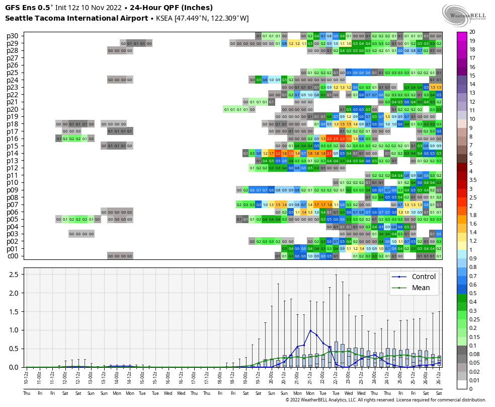
There is some uncertainty in the ensembles about when exactly the rain will return. Looking at Seattle in particular, the ECMWF ensemble broadly suggests the weekend of the 19th-20th of November.

The GFS ensemble shows a similar story.
Will there be an early start to ski season?
It’s a little early to say what this next storm cycle will look like in the WA/OR Cascades, but my initial thought is that it doesn’t look promising. Initially, storms will approach from the west and there should be some colder air remaining over the PNW. But the general trend looks warmer by Thanksgiving with temperatures to our west and northwest looking quite warm given the strong ridging.
A note on Twitter and social media
The best way to be informed of new CZ blog posts is to subscribe with your email address to have new posts immediately delivered to your inbox.
In the last year, I have found that I can reach a larger and more engaged audience by giving weather updates via Tweet rather than putting considerable time and effort into writing blog posts. However, with a migration away from Twitter appearing inevitable, I have decided to refocus my energy on writing shorter and more frequent blog posts on the Convergence Zone.
At this time I do not plan to move to a new social media site, so if you value my content, please take a moment to subscribe to this blog. The blog will remain entirely free with no advertisements for now.
Thank you! -JBZ

This week’s Fraser River outflow in Bellingham is a huge contrast to last week’s. Normally, at this time of the year, we would expect an easterly outflow to bring cold air as it did a week ago. Instead, it was quite warm. Last night at 10:35 pm at the Bellingham airport, the temperature was 28F. As easterly winds picked up, by 11:53 pm, it was 50F, a 22F increase in about an hour. The biggest gust was 47 mph from the NE at 3:53 am. There was some cooling after the 50F reading, but it is still in the mid-40’s this morning.
https://www.weather.gov/wrh/timeseries?site=KBLI
It just looks like there was no large mass of cold air in BC. Instead, we got a lot of compression heating, similar to what we would experience in the summer.
LikeLike
I bet there was a surface inversion that got mixed out by the winds as well!
LikeLike