

Western Washington and Oregon will wake up to a frontal passage on Tuesday morning as a two week hiatus in rainy season comes to an end. Rain totals will be light, with a quarter-to-third of an inch of precipitation in the Portland and Puget Sound metro areas.
The dry spell has resulted in about a 4 inch rainfall deficit for Sea-Tac airport since October 1, or about 50% of normal. Most of the PNW is running around 50-75% of normal over the same time period. Rainfall deficits of this magnitude are nothing to be concerned about and can be erased by a couple of decent storms. While there are no major storms on the horizon, we should at least be able to keep pace with normal precipitation over the next week or two. Plus, some of that precipitation may fall as snow at relatively low elevations.
Another Alaska blocking pattern
There have already been two ‘Alaska blocks’ this November — one at the beginning of the month that lead to a cold snap over the PNW, and a second last week that sent cold air to the eastern two-thirds of North America.
A third Alaska block is expected to build this weekend. The forecast 500 hPa height anomalies for this upcoming weekend show a moderate-strength ridge (reds/oranges) centered over southwestern Alaska and a shortwave trough (blue colors) approaching the PNW.
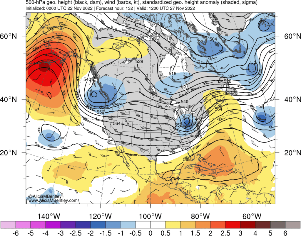
This initial trough will bring a modified arctic airmass approaching from the northwest. As seen in the 850 hPa temperature anomalies, this is a maritime cold airmass, not a continental one.

Snow levels should drop below the passes in the PNW but remain well above the lowlands.
The second phase of this pattern is a little more interesting. The 192-hour GFS 500 hPa anomalies show the Alaska ridge remaining in place for the middle of next week (roughly November 29), with a second, stronger trough over the PNW.
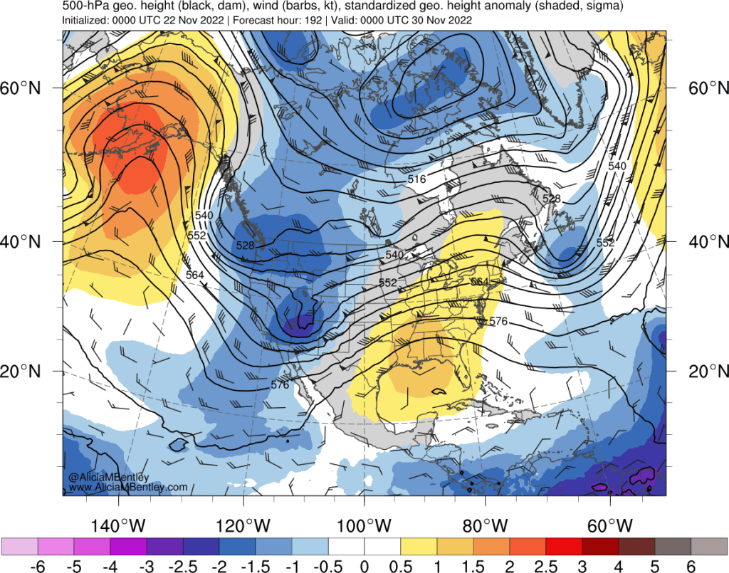
This one should be even colder than the first. The 850 hPa anomalies corresponding to the above map show another modified cold air mass approaching from the Pacific, as well as cold air over much of western Canada.

This period, encompassing roughly next Wednesday through the first weekend of December, will bear close watching for low snow levels. At the very least, it should allow for more snowpack to build up at ski areas.
Any further details?
Both the GFS and ECMWF ensembles agree on the general pattern outlined above. As of Monday night, there is almost no agreement on the details.
As an example, here’s the ECMWF ensemble surface temperature forecasts for Sea-Tac airport from the 12 UTC run on Monday.

The green line in the lower panel shows the ensemble mean, which suggests that temperatures in the 30s are the most likely outcome in Seattle. Almost 90% of the individual ensemble members show the trend toward cold weather, suggesting high confidence in the pattern change. About 20% of the individual members show impressive cold with temperatures dropping to the 20s.
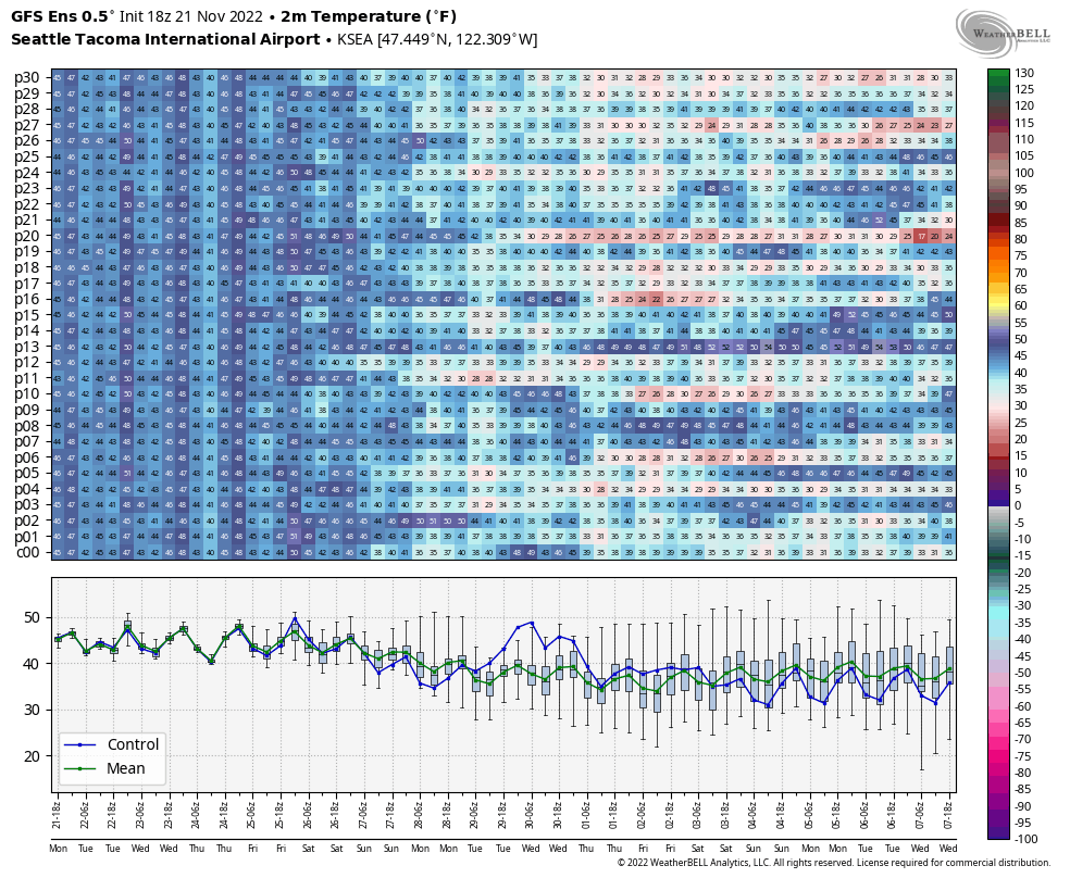
The GFS ensemble for Sea-Tac (from the 18 UTC Monday run) paints a similar picture, with an 80-90% chance of a cold snap and roughly a 10% chance of a significant cold snap.
Precipitation forecasts are all over the place so it isn’t even worth speculating. I’ll post another update when the models come into better agreement.
