

April 1 is traditionally considered the milestone date for evaluating winter rainfall and snowpack across the western US. Unfortunately, the winter of 2021-22 did little to relieve the drought that was already widespread across the western US prior to rainy season.
The latest US drought monitor continues to show severe drought conditions (D2-D4) across 75% of the western US.
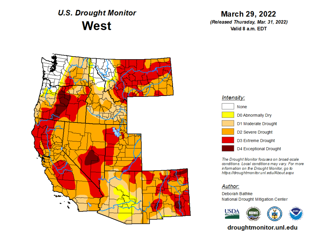
With dry season on the way, it is highly likely that drought will worsen through the summer.
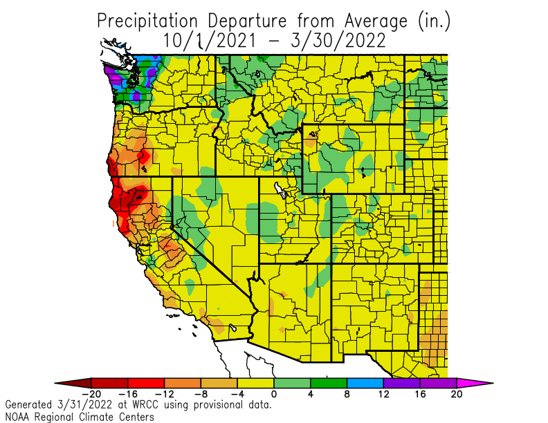
A mixed picture in the Pacific Northwest
This winter, the Columbia River has roughly defined a boundary between the ‘haves’ and the ‘have nots’.
One of the only areas that has seen plenty of precipitation is western Washington. Precipitation anomalies since the start of the water year (October 1) have been over 10 inches in parts of the Olympics and Washington Cascades. Some of this rainfall surplus has come at the expense of western Oregon and northern California, where rainfall deficits have exceeded 10 inches in some spots.
Snowpack
Snowpack departures from normal on April 1 are mostly consistent with the precipitation departure map above.
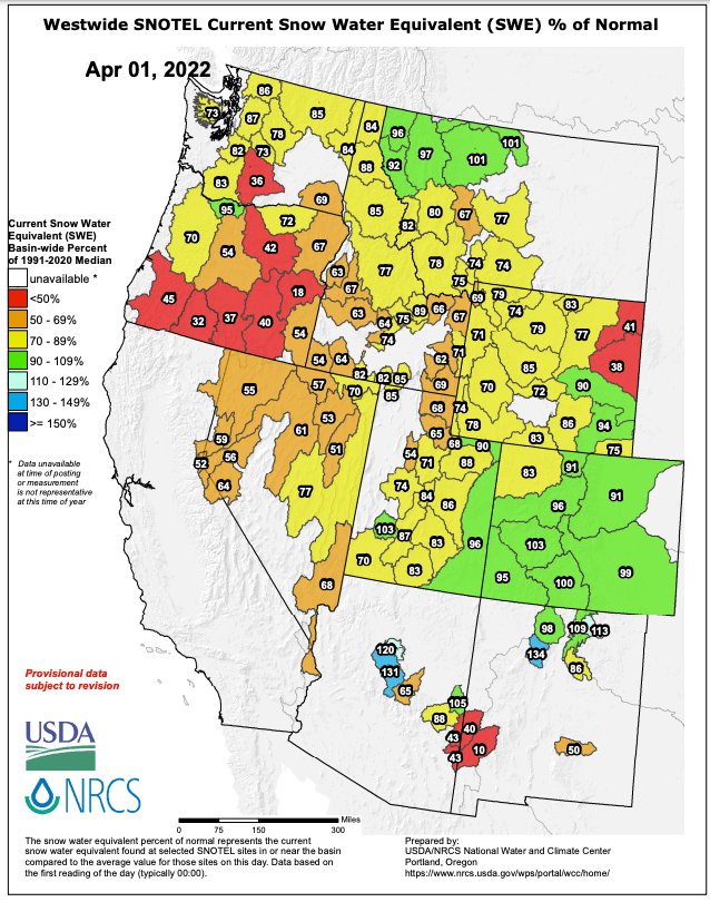
Colorado and northern Montana are the only regions that are anywhere near normal. Southern Oregon and the Sierra Nevada have seen an incredibly low snowpack year. The remaining snowpack in California is rapidly disappearing.
In Washington, it may be surprising to note that snowpack is below normal despite the above-average precipitation and near-average temperatures. Unfortunately, a large portion of that precipitation was not captured as snowpack because it fell during a series of memorable atmospheric river storms back in November.
Water supply shortages
As the drought stretches on with no end in sight, concerns about the water supply in the western US have continued to grow.
California’s largest reservoir, Shasta Lake, is currently at its lowest storage level at this time of year since 1976-77.

California is hardly alone — Lake Mead and Lake Powell are both at historic lows as a consequence of the multi-year drought and climate change. It is unlikely that the reservoirs will ever return to past high levels.
Summer wildfire season
Areas impacted by the worst of the drought, including California and southern Oregon, will undoubtedly see extreme wildfire danger early in the summer.
Will this lead to widespread fires and smoke? It’s tough to say. Climate change and drought can often be thought of as “loading the dice” for summer wildfire season, making it more likely that wildfires will grow out of control.

However, most large wildfires tend to be triggered by specific events such as lightning, human negligence, or strong winds. In recent years we have often seen that the worst wildfires often blow up as a result of one or two specific weather events. The WA/OR fires of September 2020 were a good example of such a weather event — a highly anomalous early season trough produced strong easterly winds through the Cascades.
Crossing our fingers for favorable weather is a poor way to hope for a mild fire season, but that appears to be what we’re headed for in summer 2022.

This has certainly been an odd weather pattern for Bellingham for the last 6 months. April turned out to be cold and dry. Average temperatures for April were 2F to 3F below normal while precipitation was half of normal. This reduced precipitation started last December. Since January 1, precipitation is more than 5 inches below normal (even if Mt. Baker has been getting its share of snow.) We are receiving our first bit of significant rain today in quite a while. Even though Bellingham is about 4 inches above normal for the water year starting on October 1, this is solely a result of the large amount of precipitation producing floods in the end of October 2021 and continuing into November 2021. Those heavy rains set 6 daily records with a total of over 10 inches of precipitation. Since then, during what is our normal rainy season, no month has been above normal.
LikeLike
May pretty much continued the cool pattern of April here in Bellingham, although precipitation was a bit above average for the month. Our average nighttime low was slightly below normal, but the average daytime high was considerably below normal (e.g., -4F). Precipitation was only .8″ above normal for the month, which is not much of a difference. We are still about 4″ below normal for the calendar year. Three wet days in the first half of the month accounted for 75% of the monthly rainfall. The garden is doing quite well with cooler growing vegetables. We will see about tomatoes, beans, and corn, though. We do have all of them in in the ground, but in raised beds (and the tomatoes are tented as well).
LikeLike